- Summit ridge panorama — The payoff: a wide, exposed ridge that gives sweeping views of Eritrea’s highlands and, on very clear days, the distant glint of the Red Sea. It feels more raw and lonely than touristy peaks elsewhere, so the silence up there is part of the attraction.
- Sunrise and sunset light on the escarpment — The steep faces and plateaus pick up color in dramatic ways as the sun moves, turning reds and ochres into something photographic without trying. Hiking an hour before dawn (or pushing to stay for sunset) will reward you with the kind of light most day-trippers never see.
- Rugged geology and varied terrain — Expect a mix of rocky outcrops, narrow gullies and flat wooded plateaus that make the trail feel more varied than a simple uphill slog. Those rock formations and ledges … read more 👉
- Summit ridge panorama — The payoff: a wide, exposed ridge that gives sweeping views of Eritrea’s highlands and, on very clear days, the distant glint of the Red Sea. It feels more raw and lonely than touristy peaks elsewhere, so the silence up there is part of the attraction.
- Sunrise and sunset light on the escarpment — The steep faces and plateaus pick up color in dramatic ways as the sun moves, turning reds and ochres into something photographic without trying. Hiking an hour before dawn (or pushing to stay for sunset) will reward you with the kind of light most day-trippers never see.
- Rugged geology and varied terrain — Expect a mix of rocky outcrops, narrow gullies and flat wooded plateaus that make the trail feel more varied than a simple uphill slog. Those rock formations and ledges are fun to scramble and give the hike a proper adventure feel compared with manicured trails.
- Birds and local wildlife encounters — Raptors riding the thermals, sprightly songbirds, and small mammals like rock hyrax are common sights if you move quietly. It’s not a safari, but the variety and the chance to see species adapted to the escarpment make it a delightful stop for birders and naturalists.
- Village trails and shepherd culture — The route threads close to small highland villages and grazing areas, so you’ll get casual contact with shepherds, terraced fields and traditional stone huts. Those human touches — goats on the path, someone offering tea — make the hike feel grounded and culturally rich in a way many wilderness-only trails aren’t.
Spotted a mistake or missing something? Contact us.


 Best Backpacking
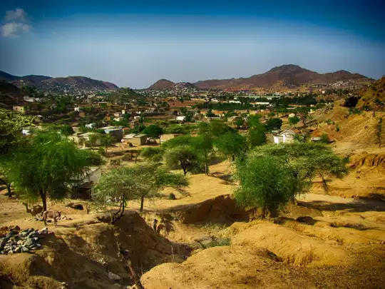
.jpg) Hi, I’m Johan (Netherlands 🇳🇱), the creator of TakeYourBackpack. Over the past decade, I’ve backpacked through 80+ countries across six continents, gaining extensive experience with independent travel, long-term trips, and overland routes.
Hi, I’m Johan (Netherlands 🇳🇱), the creator of TakeYourBackpack. Over the past decade, I’ve backpacked through 80+ countries across six continents, gaining extensive experience with independent travel, long-term trips, and overland routes.