
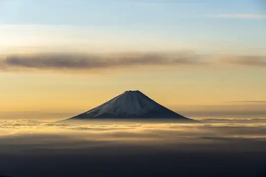
- Summit panorama (personal favorite) — The top of Asahidake delivers a brutally honest 360° view: Daisetsuzan’s rugged ridgelines, neighboring volcanoes and, on very clear days, a sliver of the Sea of Okhotsk. Morning cloud-inversions are common here, so you can sit above a sea of clouds while the peaks poke through — pure alpine theater that rewards the climb or the short ropeway boost.
- Volcanic crater and lunar slopes — Asahidake is an active volcanic massif, so parts of the trail pass stark scoria fields, steaming vents and the crater rim. That raw, otherworldly terrain feels different from forested Japanese hikes — more like hiking on a living mountain — and the sulfur-tinged air is a constant reminder you’re on volcanic ground.
- Alpine flowers and fragile high-mountain vegetation — … read more 👉
- Summit panorama (personal favorite) — The top of Asahidake delivers a brutally honest 360° view: Daisetsuzan’s rugged ridgelines, neighboring volcanoes and, on very clear days, a sliver of the Sea of Okhotsk. Morning cloud-inversions are common here, so you can sit above a sea of clouds while the peaks poke through — pure alpine theater that rewards the climb or the short ropeway boost.
- Volcanic crater and lunar slopes — Asahidake is an active volcanic massif, so parts of the trail pass stark scoria fields, steaming vents and the crater rim. That raw, otherworldly terrain feels different from forested Japanese hikes — more like hiking on a living mountain — and the sulfur-tinged air is a constant reminder you’re on volcanic ground.
- Alpine flowers and fragile high-mountain vegetation — In summer the upper slopes explode with hardy alpine species: gentians, saxifrages and mats of tiny, colorful blooms that only survive above the treeline. The plants are short and delicate, so the views aren’t just about vistas but also these rare botanical carpets you won’t see on lower-elevation trails.
- Wildlife encounters — including the rock ptarmigan — Daisetsuzan is one of the last refuges of the Japanese rock ptarmigan, plus you may spot marmot-like rodents, foxes or Ezo deer lower down. Sightings aren’t guaranteed, but the alpine birds and mammals here are specially adapted to the harsh climate, which makes any encounter feel notable compared with more trafficked lowland trails.
- Asahidake Ropeway and quick access to high alpine — The ropeway rockets you up into the alpine zone, letting hikers experience true high-mountain scenery without a multi-day approach. That makes Asahidake unusually accessible: you can get above the treeline, wander ridgelines and still be back in town the same day — great for photographers, tired legs, or anyone who wants serious alpine scenery on a budget of time.
Spotted a mistake or missing something? Contact me.

 Best Backpacking


.jpg) Hi, I’m Johan (Netherlands 🇳🇱), the creator of TakeYourBackpack. Over the past decade, I’ve backpacked through 80+ countries across six continents, gaining extensive experience with independent travel, long-term trips, and overland routes.
Hi, I’m Johan (Netherlands 🇳🇱), the creator of TakeYourBackpack. Over the past decade, I’ve backpacked through 80+ countries across six continents, gaining extensive experience with independent travel, long-term trips, and overland routes.