×

Pakistan🇵🇰 | hikesNanga Parbat Base CampDiamir face, Fairy Meadows contrast, high base camp | things to do and best time to go

Explore Karambar LakeExplore Rakaposhi Base Camp

Backpacking in Nanga Parbat Base Camp
🏆 Top pickhike ranked #3
By Johan Kruseman 🇳🇱 | Updated September 29, 2026

Here's the thing most trekkers don't figure out until they're already at the trailhead: you don't need a permit or a liaison officer for Fairy Meadows and the Nanga Parbat Base Camp trek, unlike the big Karakoram expeditions further north. That alone makes this route to the base of the world's ninth-highest peak one of the most accessible serious treks in Pakistan. It sits in the Diamer district of Gilgit-Baltistan, reached via a jeep track branching off the Karakoram Highway near Raikot Bridge. The trek itself runs three to four days round trip from Fairy Meadows, moderate in difficulty with a long, lung-testing climb through pine forest before the trees fall away. I remember cresting the ridge above Beyal Camp, legs burning, and having the entire Rupal Face just detonate into view, ice cliffs catching the last light. Compared to Ghulkin or the Hunza valley walks, it's shorter but punchier, and getting to the jeep stop by public bus from Gilgit is genuinely easy.

Discover everything you want to know in the 📖 Pakistan Travel Guide.
Best time to go: May - September
Duration: 3 days
Distance: 27 kilometers
Total ascent: 1400 meters


Get your Pakistan guide
98 ranked highlights, routes & tips, works offline (338 pages)
Loading the map 🌍
CLICK TO FILTER
cities
towns
villages
landmarks
national parks
hikes
beaches
attractions
festivals
regions
SHOW COUNTRY’S BESTSHOW ALL

✨ Why go?
Ranked #3 hike in Pakistan
What sets this place apart

Backpackers chase this trek because the scenery-to-effort ratio is absurd: three or four days of walking buys you eye-level views of the Rupal Face and Diamir Face of Nanga Parbat, an 8,126-meter wall of rock and ice, without any technical climbing. Public transport access gets you most of the way, with local buses running from Gilgit to the Raikot Bridge turnoff and jeeps covering the brutal final ascent to Fairy Meadows. Costs stay low by regional trekking standards, guesthouse beds and home-cooked meals in Fairy Meadows and Beyal Camp run a fraction of what comparable Himalayan lodges charge in Nepal. The trail also offers flexible distances, you can turn around after a day at Fairy Meadows itself or push on to Beyal Camp and Base Camp for the full payoff. It slots neatly into a longer … read more 👉
Backpackers chase this trek because the scenery-to-effort ratio is absurd: three or four days of walking buys you eye-level views of the Rupal Face and Diamir Face of Nanga Parbat, an 8,126-meter wall of rock and ice, without any technical climbing. Public transport access gets you most of the way, with local buses running from Gilgit to the Raikot Bridge turnoff and jeeps covering the brutal final ascent to Fairy Meadows. Costs stay low by regional trekking standards, guesthouse beds and home-cooked meals in Fairy Meadows and Beyal Camp run a fraction of what comparable Himalayan lodges charge in Nepal. The trail also offers flexible distances, you can turn around after a day at Fairy Meadows itself or push on to Beyal Camp and Base Camp for the full payoff. It slots neatly into a longer Karakoram Highway route, sitting between Gilgit and Chilas, so travelers already moving through the region can detour in without much logistical rework. No permits, no bureaucracy, just a jeep ride and your own legs.
Want to include Nanga Parbat Base Camp in your Pakistan route?
Create a personalized Pakistan itinerary that includes Nanga Parbat Base Camp and the places that fit your trip — based on your travel style, budget, and available time. Get your route in seconds.

Generate my trip

💡 HighlightsMust-see experiences and standout moments

  1. Fairy Meadows Viewpoint: The first big payoff of the trek, a grassy plateau ringed by pine forest with Nanga Parbat's summit pyramid filling the sky directly ahead. Most people camp here at least one night just to watch the alpenglow hit the summit.
  2. Beyal Camp: A high meadow roughly a half-day's walk above Fairy Meadows, this is where the trees disappear and the scale of the mountain really lands. It's my personal favorite stop on the whole route, the silence up there combined with the ice-fall sounds cracking off the glacier is something you feel in your chest.
  3. Nanga Parbat Base Camp (Rupal or Diamir side, depending on route): The turnaround point for most trekkers, offering close-up views of the glacier moraine and, on clear days, the sheer 4,600-meter Rupal Face, one of the tallest mountain
… read more 👉
  1. Fairy Meadows Viewpoint: The first big payoff of the trek, a grassy plateau ringed by pine forest with Nanga Parbat's summit pyramid filling the sky directly ahead. Most people camp here at least one night just to watch the alpenglow hit the summit.
  2. Beyal Camp: A high meadow roughly a half-day's walk above Fairy Meadows, this is where the trees disappear and the scale of the mountain really lands. It's my personal favorite stop on the whole route, the silence up there combined with the ice-fall sounds cracking off the glacier is something you feel in your chest.
  3. Nanga Parbat Base Camp (Rupal or Diamir side, depending on route): The turnaround point for most trekkers, offering close-up views of the glacier moraine and, on clear days, the sheer 4,600-meter Rupal Face, one of the tallest mountain faces on Earth.
  4. Raikot Glacier: Visible along sections of the upper trail, this glacier feeds meltwater streams that cut through the approach route, and its crevasse fields are a stark contrast to the green meadows below.
  5. Local Shepherd Settlements: Scattered wooden huts and seasonal grazing camps used by local Gujjar herders dot the lower and mid trail, giving a real sense of how communities have worked this landscape for generations, alongside the chance to buy fresh yogurt or milk tea along the way.
Spotted a mistake or missing something? Contact us.

Things to do near Nanga Parbat Base Camp

Ratings based on Tripadvisor reviews. When you book through this link, you support our work at no extra cost to you.

🌤️ When to go?Seasonal considerations and timing

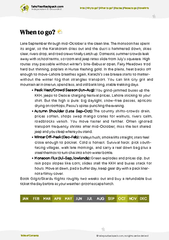
  • Peak Season (June to September): This is the reliable window, daytime temperatures at Fairy Meadows sit around 15-20°C (59-68°F), trails are clear of snow up to Base Camp, and daylight stretches past 14 hours, giving long hiking windows.
  • Shoulder Season (May and October): Fewer crowds and lower guesthouse prices, but snow can still linger on higher sections in May, and October nights drop near freezing.
  • Monsoon Overlap (July-August): Gilgit-Baltistan sees less monsoon rain than the rest of Pakistan due to the Karakoram rain shadow, but landslides on the Karakoram Highway approach can still cause delays.
  • Winter (November to April): Heavy snow closes the upper trail and Fairy Meadows guesthouses mostly shut down; jeep access becomes unreliable or impossible.
Go in early September if you can, the … read more 👉
  • Peak Season (June to September): This is the reliable window, daytime temperatures at Fairy Meadows sit around 15-20°C (59-68°F), trails are clear of snow up to Base Camp, and daylight stretches past 14 hours, giving long hiking windows.
  • Shoulder Season (May and October): Fewer crowds and lower guesthouse prices, but snow can still linger on higher sections in May, and October nights drop near freezing.
  • Monsoon Overlap (July-August): Gilgit-Baltistan sees less monsoon rain than the rest of Pakistan due to the Karakoram rain shadow, but landslides on the Karakoram Highway approach can still cause delays.
  • Winter (November to April): Heavy snow closes the upper trail and Fairy Meadows guesthouses mostly shut down; jeep access becomes unreliable or impossible.
Go in early September if you can, the summer crowds thin out but the weather still holds, and you'll likely get Beyal Camp's viewpoint nearly to yourself at sunrise.


source: climatestotravel.comJANJanuary: below average for travelingFEBFebruary: below average for travelingMARMarch: fair for travelingAPRApril: fair for travelingMAYMay: good for travelingJUNJune: highly recommended for travelingJULJuly: excellent for travelingAUGAugust: excellent for travelingSEPSeptember: highly recommended for travelingOCTOctober: fair for travelingNOVNovember: below average for travelingDECDecember: below average for traveling
pakistan-hike-nanga-parbat-base-camp
© Google |

✈️ The backpacker research shortcutPakistan Travel Guide

An offline-friendly backpacking guide with optimized travel routes, ranked highlights, transport advice, and the best areas to stay.
example page 0 from our offline Travel Guide for Pakistan
example page 1 from our offline Travel Guide for Pakistan
example page 2 from our offline Travel Guide for Pakistan
example page 3 from our offline Travel Guide for Pakistan
example page 4 from our offline Travel Guide for Pakistan
example page 5 from our offline Travel Guide for Pakistan
example page 6 from our offline Travel Guide for Pakistan
example page 7 from our offline Travel Guide for Pakistan
The digital guide (338 pages) contains:
✅ 98 highlights, ranked by travel appeal
✅ Optimized 7, 14 & 21-day travel routes
✅ Cities, national parks, landmarks, beaches
✅ How to get around
✅ Offline-friendly for travel without Wi-Fi
👉 Click to see all 30+ guide features

📅 Plan smarter in minutes, not weeks
✅ Month by month travel advice
✅ Festivals & national holidays
✅ Budget expectations

🗺️ Go to the right places, skip the overrated ones
✅ Honest pros & cons of destinations
✅ Top hikes, parks & viewpoints
✅ Lesser-known places most travelers miss
✅ Clear “worth it vs skip it” guidance

🛏️ Travel smoothly without rookie mistakes
✅ Best areas to stay
✅ Transport systems explained simply
✅ Common scams & safety advice
✅ SIM cards, money & practical tips

🌍 Understand the country, not just visit it
✅ Culture & traditions
✅ 52 Essential phrases & customs
✅ Festivals worth planning around
✅ Traveler-friendly historical context
✅ Insights that make places more meaningful

📱 Built for real travel conditions
✅ Fully downloadable PDF
✅ Works completely offline
✅ Optimized for phone use
✅ Useful in remote areas & buses
✅ Everything in one place
Save weeks of stressful planning
Get instant access to your full guide. 30‑day money-back guarantee.
+ Add another guide for just

By proceeding you agree to our terms.
Sent to your inbox immediately after payment • 100% Secure Checkout
Best Backpacking Travel Advisor 2025 tourism awardBest Backpacking
Travel Advisor
2025
What others say about Take Your Backpack Guides:
⭐⭐⭐⭐⭐
Fantastic, amazing amount of information!
⭐⭐⭐⭐⭐
My goodness this is amazing, it's what I've been looking for hats off too you!
⭐⭐⭐⭐⭐
I think this is absolutely BRILLIANT
⭐⭐⭐⭐
Very complete and informative. It's still missing places, but I gotta to commend you
⭐⭐⭐⭐⭐
This is truly amazing, thank you, can't wait to explore it with my kids!
⭐⭐⭐⭐⭐
Awesome resource, thank you!
⭐⭐⭐⭐⭐
This is amazing! Can't wait to explore the ones I haven't seen
⭐⭐⭐⭐
I love this! Well done, great idea.
⭐⭐⭐⭐⭐
Thanks for taking the time to make this gem!
⭐⭐⭐⭐⭐
This might be the best website I've ever seen.
⭐⭐⭐⭐⭐
Congratulations, and thank you so much for your work; it's incredibly valuable.
⭐⭐⭐⭐
In all seriousness I think you did a great job pointing out the important spots
⭐⭐⭐⭐⭐
10/10 very good
⭐⭐⭐⭐⭐
As someone who's only just starting to visit regularly this is awesome, thank you.
⭐⭐⭐⭐
Thank you very much! I'm going to visit my dad, it's going to be very useful!
⭐⭐⭐⭐⭐
This is really cool! We'll be travelling for the first time and this definitely come in handy.
⭐⭐⭐⭐⭐
You are now our minister of culture, congratulations 👨‍💼
⭐⭐⭐⭐⭐
Just wanted to tell you that this is a pearl! Going to follow your recommendations.
⭐⭐⭐⭐⭐
This is so cool. I'll definitely be using the resource for my travels soon.
⭐⭐⭐⭐⭐
This is very impressive! Good work.
⭐⭐⭐⭐⭐
This is an amazing and informative site. Very well done!

🛏️ Where to stay?Best areas to stay in Pakistan

If you enjoy meeting fellow travelers, consider choosing hostels with high ratings for atmosphere. On the other hand, if you prefer having your own space, a hotel might be a better option.

🥾 Hike detailsRoute, distance, and difficulty explained

Total Distance: Approximately 24-30 kilometers round trip from Fairy Meadows to Base Camp and back, depending on the exact route taken.
Estimated Duration: 3 to 4 days for most trekkers, including acclimatization time at Fairy Meadows.
Difficulty: Moderate. No technical climbing skills are required, but the altitude gain and steep sections above Beyal Camp demand decent fitness.
Starting Point: The trek begins at Tato village, reached by jeep from Raikot Bridge on the Karakoram Highway. Public buses run from Gilgit to the Raikot Bridge turnoff, where jeeps (privately hired, no fixed public schedule)
… read more 👉
Total Distance: Approximately 24-30 kilometers round trip from Fairy Meadows to Base Camp and back, depending on the exact route taken.
Estimated Duration: 3 to 4 days for most trekkers, including acclimatization time at Fairy Meadows.
Difficulty: Moderate. No technical climbing skills are required, but the altitude gain and steep sections above Beyal Camp demand decent fitness.
Starting Point: The trek begins at Tato village, reached by jeep from Raikot Bridge on the Karakoram Highway. Public buses run from Gilgit to the Raikot Bridge turnoff, where jeeps (privately hired, no fixed public schedule) climb the steep dirt track up to Tato.
Major Landmarks:
  • Fairy Meadows: The main base for trekkers, with guesthouses and direct views of Nanga Parbat's north face.
  • Beyal Camp: The last major camp before Base Camp, sitting above the treeline.
  • Nanga Parbat Base Camp: The endpoint, close to glacier moraine and the mountain's massive rock faces.
Terrain and Scenery: The trail moves from dense pine and birch forest near Tato and Fairy Meadows into open alpine meadow, then onto rocky glacial moraine near Base Camp. Views shift from forested slopes to a full wall of ice and rock as you gain elevation.
Vegetation: Lower sections are covered in pine, birch, and juniper forest, giving way to alpine grasses and wildflowers in summer at higher elevations.
Wildlife: Markhor and ibex are occasionally spotted on distant slopes, along with golden eagles overhead; marmots are common near Beyal Camp and Base Camp.
⚠️ Hiking info can sometimes be outdated or inaccurate. Before you hit the trail, check the latest conditions with locals. If you do spot anything that's off, I'd love to hear from you, so I can update it for fellow travelers.

🛡️ SafetyScams, Hazards, and Annoyances

This trek is straightforward by Karakoram standards, but altitude still matters, Fairy Meadows sits around 3,300 meters and Base Camp pushes higher, so give yourself a rest day if you're feeling breathless or headachy rather than pushing through. Weather can shift fast above Beyal Camp, clear skies can turn to cold wind and low cloud within an hour, so pack a proper shell layer even on sunny mornings. The jeep track from Raikot Bridge to Tato is rough and exposed on one side, not dangerous if drivers go slow, but it's not the place to be rushing. Footing gets loose on the moraine sections near Base Camp, trekking poles help. Wildlife encounters are rare and passive, marmots and the occasional distant ibex, nothing requiring special precaution. The main gap first-timers hit is underestimating … read more 👉
This trek is straightforward by Karakoram standards, but altitude still matters, Fairy Meadows sits around 3,300 meters and Base Camp pushes higher, so give yourself a rest day if you're feeling breathless or headachy rather than pushing through. Weather can shift fast above Beyal Camp, clear skies can turn to cold wind and low cloud within an hour, so pack a proper shell layer even on sunny mornings. The jeep track from Raikot Bridge to Tato is rough and exposed on one side, not dangerous if drivers go slow, but it's not the place to be rushing. Footing gets loose on the moraine sections near Base Camp, trekking poles help. Wildlife encounters are rare and passive, marmots and the occasional distant ibex, nothing requiring special precaution. The main gap first-timers hit is underestimating water needs and skipping proper acclimatization before the Beyal Camp push.

FAQCommon questions from travelers

Most trekkers complete the round trip from Fairy Meadows to Nanga Parbat Base Camp and back in 3 to 4 days, including one night at Beyal Camp. Add a day if you want proper acclimatization time before pushing to Base Camp, especially if you're coming straight from lower elevations.
It's rated moderate, no technical climbing or ropework is needed, but the steep switchbacks above Beyal Camp and the altitude (Base Camp sits well above 3,500 meters) make it demanding for anyone without regular hiking fitness. Loose moraine near the top adds a bit of scrambling.
No permit is required for this trek, unlike expedition routes further into the Karakoram, and hiring a guide isn't mandatory either. That said, many independent trekkers hire a local guide in Tato or Fairy Meadows for route-finding and porter support, which typically costs a reasonable daily rate negotiated on the spot.
⚠️ Things can change over time, so always validate details locally before you go.

Other Pakistani hikes near Nanga Parbat Base Camp

Explore more nearby:


💡 Not sure where to go next?
Create a personalized itinerary for Pakistan including Nanga Parbat Base Camp and the places that fit your trip.

Generate my itinerary

👉 Discover all hikes

Or checkout all Pakistan has to offer (think cities, towns, villages, national parks, hikes, beaches, festivals)
Country photo of Pakistan

We 💚 feedbackParting advice and final tips

Worth it for the Rupal Face view alone, few treks anywhere deliver that scale of mountain for so little logistical hassle or permit paperwork. The drawback is Fairy Meadows itself getting crowded and pricier in peak July-August weeks, when tour groups flood the guesthouses. Go shoulder season if you want the mountain closer to yourself.

✈️ When did I visit Pakistan?
Even though the media portrays Pakistan often as a dangerous country, it has its great spots, and for a mountain lover like me the mountain regions in the north are just heaven. Visited Pakistan in October 2022.

✍️ Help improve this page!
The information on this page is based on my own backpacking experience in Pakistan, supplemented with up-to-date research and feedback from other travelers. Travel details can change, so if you notice anything outdated or incomplete, feel free to let me know.


🙋‍♂️ Give feedback

👋 Meet the founderWho’s Behind Take Your Backpack?

Johan, backpacker and founder of TakeYourBackpackHi, I’m Johan (Netherlands 🇳🇱), the creator of TakeYourBackpack. Over the past decade, I’ve backpacked through 80+ countries across six continents, gaining extensive experience with independent travel, long-term trips, and overland routes.

This site is built on a combination of firsthand travel experience and carefully curated insights from other backpackers. Many guides are based on places I’ve personally visited, while others bring together tips, observations, and practical advice shared by trusted travelers I’ve met along the way.

The goal is to provide realistic, experience-driven guidance — not generic itineraries — so you can explore destinations with better context, clearer expectations, and more confidence.

Get full Pakistan guide •
Instant download • 98 highlights • Full Offline guide