
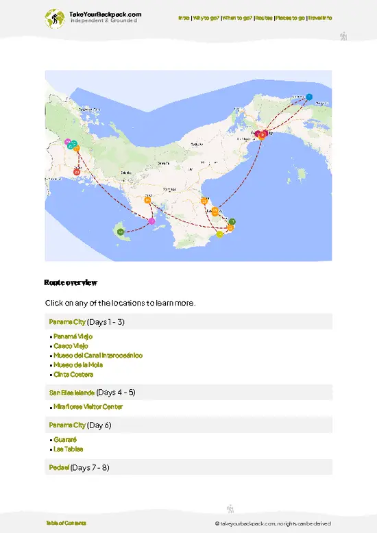
- Summit of Volcán Barú (3,474 m): Panama’s highest point is a rocky crown crowded with radio and television antennas, with a marker where hikers take their summit photos. The final stretch is bare volcanic rock and low shrubs, and the thin air makes the last kilometer feel longer than it is.
- Two-Ocean View at Dawn: On a clear morning the Pacific lies to the south with the Gulf of Chiriquí islands, and the Caribbean shows to the north beyond the Talamanca ridges. Cloud often fills the valleys below, so you stand above a white floor, and the view usually lasts only an hour or two before the haze rolls in.
- The Summit Craters: Near the top you can walk to the rim of several old craters and look down into deep, rock-filled bowls. Some are wide and shallow, others drop steeply, and the ground is reddish
- Summit of Volcán Barú (3,474 m): Panama’s highest point is a rocky crown crowded with radio and television antennas, with a marker where hikers take their summit photos. The final stretch is bare volcanic rock and low shrubs, and the thin air makes the last kilometer feel longer than it is.
- Two-Ocean View at Dawn: On a clear morning the Pacific lies to the south with the Gulf of Chiriquí islands, and the Caribbean shows to the north beyond the Talamanca ridges. Cloud often fills the valleys below, so you stand above a white floor, and the view usually lasts only an hour or two before the haze rolls in.
- The Summit Craters: Near the top you can walk to the rim of several old craters and look down into deep, rock-filled bowls. Some are wide and shallow, others drop steeply, and the ground is reddish and loose with stones, a reminder that this is volcanic terrain.
- Resplendent Quetzal Habitat: The mid-slope oak and cloud forest, within Volcán Barú National Park, is among the best places in Panama to look for the quetzal, especially in the early months of the year when the birds are nesting. Even without a quetzal, you hear and see hummingbirds and mossy trunks dripping with epiphytes.
- Sendero Los Quetzales: This roughly 8-kilometer trail links Cerro Punta and Boquete along the flank of the volcano. It runs through damp forest with log bridges and river crossings, and it is the gentler alternative if the full summit road is too much.
Spotted a mistake or missing something? Contact us.


 Best Backpacking
 Hi, I’m Johan (Netherlands 🇳🇱), the creator of TakeYourBackpack. Over the past 3 decades, I’ve backpacked through 90+ countries across six continents, gaining extensive experience with independent travel, long-term trips, and overland routes.