

×

St. Lucia🇱🇨 | hikesTet Paul Nature TrailFamily-run loop, stone steps, spice plots, bay lookouts | things to do and best time to go

Explore Gros Piton TrailExplore Enbas Saut Rainforest Trail

Backpacking in Tet Paul Nature Trail
🌟 Highlighthike ranked #2
By Johan Kruseman 🇳🇱 | Updated October 22, 2026

The trail is family-run, so your entry fee pays a local guide who walks you round, and you cannot go solo. Tet Paul Nature Trail sits on a ridge above Soufrière in the southwest of Saint Lucia, at Chateau Belair just east of the two Pitons. It is a short loop of about 1 kilometer, with steps and some steeper rocky bits, so a moderate fitness level is plenty. The views of Gros Piton and Petit Piton over the Caribbean are the big draw, and the guide explains the crops and bush medicine along the way. The downside is length: it is over in about an hour, and the heat builds fast by late morning. Soufrière is the base for the start, and a minibus or taxi from the town gets you to the gate. Go early or late in the day. Unlike the long, sweaty climb up Gros Piton, this is a gentle stroll with the same view.

Part of Backpacking in St. Lucia: all 31 places on one map, with routes and the best time to go.
Discover everything you want to know in the 📖 St. Lucia Travel Guide.
Best time to go: November - May
Duration: 1 hour
Distance: 1 kilometer
Total ascent: 100 meters
Loading the map 🌍
CLICK TO FILTER
towns
landmarks
national parks
hikes
beaches
attractions
festivals
regions
SHOW COUNTRY’S BESTSHOW ALL

✨ Why go?
Ranked #2 hike in St. Lucia
What makes this hike worth hiking

Tet Paul Nature Trail gives you the postcard angle of the twin Pitons without the all-day grind of climbing either one. You stand on a ridge with the sea on one side and both peaks framed together, which you cannot get from the base or the beach. That makes it a smart pick for a rest day between harder hikes, or for anyone with bad knees who still wants the panorama.

The second reason is the guide. The route is walked with a local who points out cocoa, cassava, breadfruit and bush medicine plants, and tells you what each is used for in Soufrière kitchens and homes. You come away knowing more about village life than a viewpoint stop would ever teach you.

It also slots easily into a trip around Soufrière. The loop takes about an hour, so you can pair it with a morning hike, a sulfur springs … read more 👉
Tet Paul Nature Trail gives you the postcard angle of the twin Pitons without the all-day grind of climbing either one. You stand on a ridge with the sea on one side and both peaks framed together, which you cannot get from the base or the beach. That makes it a smart pick for a rest day between harder hikes, or for anyone with bad knees who still wants the panorama.

The second reason is the guide. The route is walked with a local who points out cocoa, cassava, breadfruit and bush medicine plants, and tells you what each is used for in Soufrière kitchens and homes. You come away knowing more about village life than a viewpoint stop would ever teach you.

It also slots easily into a trip around Soufrière. The loop takes about an hour, so you can pair it with a morning hike, a sulfur springs visit or an afternoon swim. Bring cash for the fee and a tip.

💡 HighlightsKey sights and experiences for travelers

  1. The Twin Pitons Viewpoint: The summit platform at the end of the steps gives a direct view of Gros Piton and Petit Piton rising from the sea, with the gap between them framing the water. This is the shot people travel here for.
  2. The Stairway to Heaven: The long run of stone and concrete steps up the ridge is the trail’s signature stretch. It is steep in places but has rails and rest points, and the views widen with each landing.
  3. Garden of Spices and Crops: Your guide stops at plots of cocoa, cassava, bananas, breadfruit and herbs. You can touch, smell and taste some of them, and learn how locals use them for food and remedies.
  4. Soufrière Bay and Town View: From the upper lookouts you see the curve of the bay, the town’s rooftops and fishing boats on the water. It helps you understand how the town
… read more 👉
  1. The Twin Pitons Viewpoint: The summit platform at the end of the steps gives a direct view of Gros Piton and Petit Piton rising from the sea, with the gap between them framing the water. This is the shot people travel here for.
  2. The Stairway to Heaven: The long run of stone and concrete steps up the ridge is the trail’s signature stretch. It is steep in places but has rails and rest points, and the views widen with each landing.
  3. Garden of Spices and Crops: Your guide stops at plots of cocoa, cassava, bananas, breadfruit and herbs. You can touch, smell and taste some of them, and learn how locals use them for food and remedies.
  4. Soufrière Bay and Town View: From the upper lookouts you see the curve of the bay, the town’s rooftops and fishing boats on the water. It helps you understand how the town sits under the volcanic peaks.
  5. Rock Pathway and Coastal Lookouts: The last section crosses bare volcanic rock and low bush, with open views along the coast. Wind here is steady, which cools you down and makes it a good place to pause.
Tet Paul Nature Trail is best started with the Twin Pitons Viewpoint if you arrive early and the sky is clear, because haze and cloud often build over the peaks later in the day.
Spotted a mistake or missing something? Contact us.

Things to do around Tet Paul Nature Trail

Ratings based on Tripadvisor reviews. When you book through this link, you support our work at no extra cost to you.

🌤️ When to go?Seasonal considerations and timing

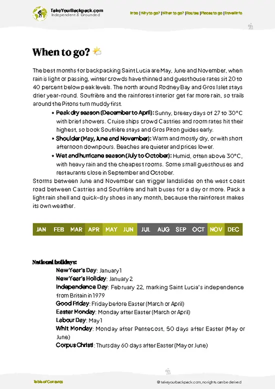
  • Dry Season (December to May): The trail is driest and the views over the Pitons and Jalousie Bay are clearest. Highs run 28 to 31°C (82 to 88°F), with cooler mornings near 22°C (72°F). Daylight lasts about 11 to 12 hours, so start by mid-morning at the latest.
  • Christmas to Easter: Cruise-ship days and Soufrière tour buses bring the biggest groups, and local tour rates are at their highest. Arrive right at opening to have the ledges to yourself.
  • Wet Season (June to November): Expect short, heavy downpours, humidity and slick clay on the steps. Temperatures stay similar, 27 to 31°C (81 to 88°F), but the greenery is thicker and prices for rooms nearby drop. Hurricane season peaks from August to October.
  • Shoulder Months (May, June, November): Fewer visitors, fair weather most days and softer prices
… read more 👉
  • Dry Season (December to May): The trail is driest and the views over the Pitons and Jalousie Bay are clearest. Highs run 28 to 31°C (82 to 88°F), with cooler mornings near 22°C (72°F). Daylight lasts about 11 to 12 hours, so start by mid-morning at the latest.
  • Christmas to Easter: Cruise-ship days and Soufrière tour buses bring the biggest groups, and local tour rates are at their highest. Arrive right at opening to have the ledges to yourself.
  • Wet Season (June to November): Expect short, heavy downpours, humidity and slick clay on the steps. Temperatures stay similar, 27 to 31°C (81 to 88°F), but the greenery is thicker and prices for rooms nearby drop. Hurricane season peaks from August to October.
  • Shoulder Months (May, June, November): Fewer visitors, fair weather most days and softer prices make these a smart compromise.
Go on a weekday morning, since the heat builds fast on the exposed upper section by noon.


source: climatestotravel.comJANJanuary: highly recommended for travelingFEBFebruary: highly recommended for travelingMARMarch: highly recommended for travelingAPRApril: highly recommended for travelingMAYMay: highly recommended for travelingJUNJune: fair for travelingJULJuly: fair for travelingAUGAugust: fair for travelingSEPSeptember: fair for travelingOCTOctober: fair for travelingNOVNovember: good for travelingDECDecember: highly recommended for traveling

✈️ The backpacker research shortcutSt. Lucia Travel Guide

What the free pages can't give you: ready-made routes, every place ranked, and it works offline. All in 1 guide.
example page 0 from our offline Travel Guide for Saint Lucia
example page 1 from our offline Travel Guide for Saint Lucia
example page 2 from our offline Travel Guide for Saint Lucia
example page 3 from our offline Travel Guide for Saint Lucia
example page 4 from our offline Travel Guide for Saint Lucia
example page 5 from our offline Travel Guide for Saint Lucia
example page 6 from our offline Travel Guide for Saint Lucia
example page 7 from our offline Travel Guide for Saint Lucia
The digital guide (125 pages) contains:-page digital guide:
✅ Ready-made 2, 3 & 5-day routes
✅ All 31 places ranked, so you skip the overrated ones
✅ Works offline, all in 1 guide
✅ Cities, national parks, landmarks, beaches
✅ How to get around
👉 Click to see all 30+ guide features

📅 Plan smarter in minutes, not weeks
✅ Month by month travel advice
✅ Festivals & national holidays
✅ Budget expectations

🗺️ Go to the right places, skip the overrated ones
✅ Honest pros & cons of destinations
✅ Top hikes, parks & viewpoints
✅ Lesser-known places most travelers miss
✅ Clear “worth it vs skip it” guidance

🛏️ Travel smoothly without rookie mistakes
✅ Best areas to stay
✅ Transport systems explained simply
✅ Common scams & safety advice
✅ SIM cards, money & practical tips

🌍 Understand the country, not just visit it
✅ Culture & traditions
✅ 52 Essential phrases & customs
✅ Festivals worth planning around
✅ Traveler-friendly historical context
✅ Insights that make places more meaningful

📱 Built for real travel conditions
✅ Fully downloadable PDF
✅ Works completely offline
✅ Optimized for phone use
✅ Useful in remote areas & buses
✅ All in 1 guide
Stop searching, start planning
Get instant access to your full guide. 30‑day money-back guarantee.


By proceeding you agree to our terms.
Sent to your inbox immediately after payment • 100% Secure Checkout
Best Backpacking Travel Advisor 2025 tourism awardBest Backpacking
Travel Advisor
2025
What others say about Take Your Backpack Guides:
⭐⭐⭐⭐⭐
Fantastic, amazing amount of information!
⭐⭐⭐⭐⭐
My goodness this is amazing, it's what I've been looking for hats off too you!
⭐⭐⭐⭐⭐
I think this is absolutely BRILLIANT
⭐⭐⭐⭐
Very complete and informative. It's still missing places, but I gotta to commend you
⭐⭐⭐⭐⭐
This is truly amazing, thank you, can't wait to explore it with my kids!
⭐⭐⭐⭐⭐
Awesome resource, thank you!
⭐⭐⭐⭐⭐
This is amazing! Can't wait to explore the ones I haven't seen
⭐⭐⭐⭐
I love this! Well done, great idea.
⭐⭐⭐⭐⭐
Thanks for taking the time to make this gem!
⭐⭐⭐⭐⭐
This might be the best website I've ever seen.
⭐⭐⭐⭐⭐
Congratulations, and thank you so much for your work; it's incredibly valuable.
⭐⭐⭐⭐
In all seriousness I think you did a great job pointing out the important spots
⭐⭐⭐⭐⭐
10/10 very good
⭐⭐⭐⭐⭐
As someone who's only just starting to visit regularly this is awesome, thank you.
⭐⭐⭐⭐
Thank you very much! I'm going to visit my dad, it's going to be very useful!
⭐⭐⭐⭐⭐
This is really cool! We'll be travelling for the first time and this definitely come in handy.
⭐⭐⭐⭐⭐
You are now our minister of culture, congratulations 👨‍💼
⭐⭐⭐⭐⭐
Just wanted to tell you that this is a pearl! Going to follow your recommendations.
⭐⭐⭐⭐⭐
This is so cool. I'll definitely be using the resource for my travels soon.
⭐⭐⭐⭐⭐
This is very impressive! Good work.
⭐⭐⭐⭐⭐
This is an amazing and informative site. Very well done!

🛏️ Where to stay?Best areas to stay in St. Lucia

If you enjoy meeting fellow travelers, consider choosing hostels with high ratings for atmosphere. On the other hand, if you prefer having your own space, a hotel might be a better option.

🥾 Hike detailsA practical overview of the hike

Total Distance: Tet Paul Nature Trail is a loop of roughly 1 kilometer.
Estimated Duration: Around 45 to 75 minutes with the guide, depending on how long you stop for plants and photos.
Difficulty: Easy to moderate. The climb is short but steep in places, and the steps can feel tiring in the heat.
Starting Point: The gate is on the ridge above Soufrière. Minibuses run to Soufrière from Castries and Vieux Fort, and from the town you can take a taxi or a local minibus up toward the trailhead.
Major Landmarks:
  • Crop Gardens: Small plots of cocoa, cassava and spices near the start.
  • Stair Sections: The main
… read more 👉
Total Distance: Tet Paul Nature Trail is a loop of roughly 1 kilometer.
Estimated Duration: Around 45 to 75 minutes with the guide, depending on how long you stop for plants and photos.
Difficulty: Easy to moderate. The climb is short but steep in places, and the steps can feel tiring in the heat.
Starting Point: The gate is on the ridge above Soufrière. Minibuses run to Soufrière from Castries and Vieux Fort, and from the town you can take a taxi or a local minibus up toward the trailhead.
Major Landmarks:
  • Crop Gardens: Small plots of cocoa, cassava and spices near the start.
  • Stair Sections: The main climb, with railings and rest areas.
  • Summit Platform: The famous view of both Pitons and the Caribbean Sea.
Terrain and Scenery: Stone steps, packed earth and bare volcanic rock. Views open to the Pitons, Soufrière Bay and the coast.
Vegetation: Cultivated crops, tropical shrubs, grasses and some dry-forest plants on the ridge.
Wildlife: Expect lizards, hummingbirds and other small birds. Larger animals are rare.
Practical Notes: Wear closed shoes with grip, bring a hat and water, and carry small cash for the fee and a guide tip.
⚠️ Hiking info can sometimes be outdated or inaccurate. Before you hit the trail, check the latest conditions with locals. If you do spot anything that's off, I'd love to hear from you, so I can update it for fellow travelers.

🛡️ SafetyScams, Hazards, and Annoyances

Tet Paul is a short, well-maintained, guided trail, so the real issues are sun, slick footing and a few steep sections rather than anything dramatic. The path climbs stone and dirt steps to roughly 300 meters (about 1,000 feet) above the sea, and the upper stretches are open with almost no shade. Wear a hat, use sunscreen and carry a liter or two of water. After rain the clay and stone get slippery, so choose shoes with real grip over flip-flops. Two ledges and a narrow stair near the top have drops, but handrails and a steady pace make them manageable. Keep children close at the viewpoints. You may see lizards, birds and the odd harmless snake or insect, so stay on the path and leave plants alone. Guides are local farmers and know the garden plots, so follow their lead and ask before you pick or photograph anything.

FAQTraveler FAQ

Plan on 45 minutes to 1.5 hours for the Tet Paul Nature Trail, depending on how long you linger at the viewpoints. The loop is about 1 kilometer (0.6 miles) with a guided walk and stops at the Pitons lookouts. The trailhead sits just above Soufrière, roughly a 10 to 15 minute drive from town.
The Tet Paul Nature Trail is easy to moderate, with a steady climb up uneven stone steps and no technical scrambling. It gains about 150 to 200 meters (roughly 500 to 650 feet) over a short distance, so the effort is brief but sweaty. Most fit hikers manage it in sandals with grip or sneakers, and slower walkers can pause at the benches along the way.
Yes, the Tet Paul Nature Trail is walked with a local guide who is included in the entry fee, and there is no separate permit to arrange. Admission is about US$10 to 12 per adult, paid in cash at the gate, and guides are usually available when it is open during the day. Tips for the guide are appreciated, and most visitors simply turn up without booking ahead.
⚠️ Things can change over time, so always validate details locally before you go.

Other Saint Lucian hikes near Tet Paul Nature Trail

Explore more nearby:


💡 Not sure where to go next?
Create a personalized itinerary for St. Lucia including Tet Paul Nature Trail and the places that fit your trip.

Generate my itinerary

👉 Discover all hikes

Or checkout all St. Lucia has to offer (think cities, towns, villages, national parks, hikes, beaches, festivals)
Country photo of St. Lucia

We 💚 feedbackSumming up the experience

Tet Paul Nature Trail works best as the gentle half of a Soufrière day, paired with a harder hike or a swim at the nearby beaches. I would walk it first thing, then spend the afternoon at the sulfur springs or in the sea. Wear shoes with grip, since the steps get slick after rain.

✍️ Help improve this page!
The information on this page is based on in-depth research, insights shared by experienced travelers, and feedback from the local travel community in St. Lucia. While every effort is made to keep the information accurate and current, conditions can change — so if you spot anything incorrect or outdated, please get in touch.


🙋‍♂️ Give feedback

👋 Meet the founderWho’s Behind Take Your Backpack?

Johan, backpacker and founder of TakeYourBackpackHi, I’m Johan (Netherlands 🇳🇱), the creator of TakeYourBackpack. Over the past 30 years, I’ve backpacked through 88 countries across six continents, gaining extensive experience with independent travel, long-term trips, and overland routes.

This site is built on a combination of firsthand travel experience and carefully curated insights from other backpackers. Many guides are based on places I’ve personally visited, while others bring together tips, observations, and practical advice shared by trusted travelers I’ve met along the way.

The goal is to provide realistic, experience-driven guidance — not generic itineraries — so you can explore destinations with better context, clearer expectations, and more confidence.