×

Timor-Leste🇹🇱 | national parksMount RamelauTatamailau summit, pre-dawn scramble, Hato Builico, highland coffee | things to do and best time to go

Explore Nino Konis Santana National ParkExplore Tilomar Reserve

Backpacking in Mount Ramelau
🌟 Highlightnational park ranked #2
By Johan Kruseman 🇳🇱 | Updated October 15, 2026

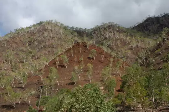
The big decision at Mount Ramelau is whether to hike the summit for sunrise, and a clear sky tips it, because cloud can swallow the view entirely by 7 a.m. The park lies in the south-west highlands of Timor-Leste, above the village of Hato Builico, and the mountain (Tatamailau, 2,963 meters) is the country’s highest point. Expect a cold start, headlamp beams on loose gravel, wet grass, woodsmoke from village kitchens, and a final scramble where the wind bites. Wildlife is modest, mostly birds in the forest edge. Roads from Dili are long and rough, so arrive the day before rather than gambling on a same-morning drive, and carry small cash because there are no ATMs nearby. Start the climb around 3 a.m. or you will miss the sunrise. Bring a warm layer and gloves. Keen early risers and pilgrims will love it. Anyone wanting varied trail networks or comfortable facilities will not.

Part of Backpacking in Timor-Leste: all 46 places on one map, with routes and the best time to go.
Discover everything you want to know in the 📖 Timor-Leste Travel Guide.
Loading the map 🌍
CLICK TO FILTER
cities
towns
villages
national parks
hikes
beaches
attractions
festivals
regions
SHOW COUNTRY’S BESTSHOW ALL

✨ Why go?
Ranked #2 national park in Timor-Leste
What sets this place apart

Backpackers choose Ramelau because it is a self-guided climb with a real summit payoff and almost no infrastructure between you and it. You can walk the route from Hato Builico without a tour operator, hiring a local guide for a small fee if you want company or help with the dark, steep sections. The mountain also carries meaning: the Virgin Mary statue on the summit draws Timorese Catholics on pilgrimage, so you share the top with locals as well as foreigners, and a Mass is sometimes held there. The surrounding highlands offer simple village stays and a slow, cool, misty pace that contrasts sharply with the coast. Coffee grows in this area, and a hot cup from a roadside stall after the descent is part of the point. If you like independent travel where logistics take a little effort and the … read more 👉
Backpackers choose Ramelau because it is a self-guided climb with a real summit payoff and almost no infrastructure between you and it. You can walk the route from Hato Builico without a tour operator, hiring a local guide for a small fee if you want company or help with the dark, steep sections. The mountain also carries meaning: the Virgin Mary statue on the summit draws Timorese Catholics on pilgrimage, so you share the top with locals as well as foreigners, and a Mass is sometimes held there. The surrounding highlands offer simple village stays and a slow, cool, misty pace that contrasts sharply with the coast. Coffee grows in this area, and a hot cup from a roadside stall after the descent is part of the point. If you like independent travel where logistics take a little effort and the setting does the rest, Ramelau fits. If you need marked, varied hiking, it is a single-objective trip, though a deeply satisfying one.

💡 HighlightsThe experiences that define the visit

  1. Summit of Mount Ramelau (Tatamailau): The highest point in Timor-Leste at 2,963 meters, with a sunrise that can light up mountains on both sides of the island on clear mornings, and a sea of cloud below on good days.
  2. Virgin Mary statue: A white statue of Our Lady stands at the summit beside a cross, and pilgrims often kneel or pray there at dawn.
  3. Sunrise from the ridge: The last stretch is a steep scramble over loose rock and grass, and reaching it before first light is the whole point of the early start.
  4. Hato Builico village: The highland base for the climb, with cool air, stone-and-thatch houses, smoke from cooking fires and a quiet market feel in the morning.
  5. Highland coffee farms: Arabica grows on the slopes around the park, and local growers sell or serve it, usually strong and sweet.
  6. Cloud
… read more 👉
  1. Summit of Mount Ramelau (Tatamailau): The highest point in Timor-Leste at 2,963 meters, with a sunrise that can light up mountains on both sides of the island on clear mornings, and a sea of cloud below on good days.
  2. Virgin Mary statue: A white statue of Our Lady stands at the summit beside a cross, and pilgrims often kneel or pray there at dawn.
  3. Sunrise from the ridge: The last stretch is a steep scramble over loose rock and grass, and reaching it before first light is the whole point of the early start.
  4. Hato Builico village: The highland base for the climb, with cool air, stone-and-thatch houses, smoke from cooking fires and a quiet market feel in the morning.
  5. Highland coffee farms: Arabica grows on the slopes around the park, and local growers sell or serve it, usually strong and sweet.
  6. Cloud forest edges: The lower trail passes pockets of mossy woodland and open grassland where you can hear and spot highland birds.
  7. Descent viewpoints: Walking down in daylight shows the valleys you missed in the dark, with terraced fields and distant ridgelines.
If time is short, skip the village wandering and coffee farms and focus on the summit climb.
Spotted a mistake or missing something? Contact us.

Things to do near Mount Ramelau

Ratings based on Tripadvisor reviews. When you book through this link, you support our work at no extra cost to you.

🌤️ When to go?Choosing the right time of year

The best window for Mount Ramelau is June to September, when the sunrise climb to the 2,963 m (9,721 ft) summit most often ends in a clear view across both coasts.
  • Dry Season (May to October): Mornings at Hato Builico start around 8 to 12°C (46 to 54°F), and summit pre-dawn readings can drop toward 3 to 6°C (37 to 43°F). Days reach 18 to 22°C (64 to 72°F). Sunrise is near 6:30 am, so you start climbing around 2:00 to 3:00 am.
  • Wet Season (November to April): Afternoon downpours, fog and slick clay on the upper path make the summit a gamble. Cloud often hides the sunrise. Guesthouse beds are easy to find and nobody haggles over them.
  • Crowds and Events: Numbers stay small even in July and August, though weekends can bring Timorese pilgrim groups. Around Easter and during the August school holidays,
… read more 👉
The best window for Mount Ramelau is June to September, when the sunrise climb to the 2,963 m (9,721 ft) summit most often ends in a clear view across both coasts.
  • Dry Season (May to October): Mornings at Hato Builico start around 8 to 12°C (46 to 54°F), and summit pre-dawn readings can drop toward 3 to 6°C (37 to 43°F). Days reach 18 to 22°C (64 to 72°F). Sunrise is near 6:30 am, so you start climbing around 2:00 to 3:00 am.
  • Wet Season (November to April): Afternoon downpours, fog and slick clay on the upper path make the summit a gamble. Cloud often hides the sunrise. Guesthouse beds are easy to find and nobody haggles over them.
  • Crowds and Events: Numbers stay small even in July and August, though weekends can bring Timorese pilgrim groups. Around Easter and during the August school holidays, expect more locals on the trail to the statue of Our Lady of Ramelau.
  • Prices: Guide and homestay rates stay flat all year.
Aim for a weekday in the dry season and book your guide the evening before.


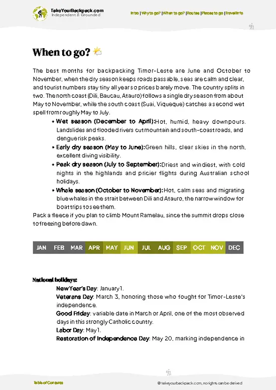
source: climatestotravel.comJANJanuary: fair for travelingFEBFebruary: fair for travelingMARMarch: fair for travelingAPRApril: fair for travelingMAYMay: highly recommended for travelingJUNJune: excellent for travelingJULJuly: excellent for travelingAUGAugust: excellent for travelingSEPSeptember: highly recommended for travelingOCTOctober: excellent for travelingNOVNovember: fair for travelingDECDecember: fair for traveling
timor-leste-national-park-mount-ramelau
© Google |

✈️ The backpacker research shortcutTimor-Leste Travel Guide

What the free pages can't give you: ready-made routes, every place ranked, and it works offline. All in 1 guide.
example page 0 from our offline Travel Guide for Timor-Leste
example page 1 from our offline Travel Guide for Timor-Leste
example page 2 from our offline Travel Guide for Timor-Leste
example page 3 from our offline Travel Guide for Timor-Leste
example page 4 from our offline Travel Guide for Timor-Leste
example page 5 from our offline Travel Guide for Timor-Leste
example page 6 from our offline Travel Guide for Timor-Leste
example page 7 from our offline Travel Guide for Timor-Leste
The digital guide (171 pages) contains:
✅ Ready-made 2, 3 & 5-day routes
✅ All 46 places ranked, so you skip the overrated ones
✅ Works offline, all in 1 guide
✅ Cities, national parks, landmarks, beaches
✅ How to get around
👉 Click to see all 30+ guide features

📅 Plan smarter in minutes, not weeks
✅ Month by month travel advice
✅ Festivals & national holidays
✅ Budget expectations

🗺️ Go to the right places, skip the overrated ones
✅ Honest pros & cons of destinations
✅ Top hikes, parks & viewpoints
✅ Lesser-known places most travelers miss
✅ Clear “worth it vs skip it” guidance

🛏️ Travel smoothly without rookie mistakes
✅ Best areas to stay
✅ Transport systems explained simply
✅ Common scams & safety advice
✅ SIM cards, money & practical tips

🌍 Understand the country, not just visit it
✅ Culture & traditions
✅ 52 Essential phrases & customs
✅ Festivals worth planning around
✅ Traveler-friendly historical context
✅ Insights that make places more meaningful

📱 Built for real travel conditions
✅ Fully downloadable PDF
✅ Works completely offline
✅ Optimized for phone use
✅ Useful in remote areas & buses
✅ All in 1 guide
Stop searching, start planning
Get instant access to your full guide. 30‑day money-back guarantee.
+ Add another guide for just

By proceeding you agree to our terms.
Sent to your inbox immediately after payment • 100% Secure Checkout
Best Backpacking Travel Advisor 2025 tourism awardBest Backpacking
Travel Advisor
2025
What others say about Take Your Backpack Guides:
⭐⭐⭐⭐⭐
Fantastic, amazing amount of information!
⭐⭐⭐⭐⭐
My goodness this is amazing, it's what I've been looking for hats off too you!
⭐⭐⭐⭐⭐
I think this is absolutely BRILLIANT
⭐⭐⭐⭐
Very complete and informative. It's still missing places, but I gotta to commend you
⭐⭐⭐⭐⭐
This is truly amazing, thank you, can't wait to explore it with my kids!
⭐⭐⭐⭐⭐
Awesome resource, thank you!
⭐⭐⭐⭐⭐
This is amazing! Can't wait to explore the ones I haven't seen
⭐⭐⭐⭐
I love this! Well done, great idea.
⭐⭐⭐⭐⭐
Thanks for taking the time to make this gem!
⭐⭐⭐⭐⭐
This might be the best website I've ever seen.
⭐⭐⭐⭐⭐
Congratulations, and thank you so much for your work; it's incredibly valuable.
⭐⭐⭐⭐
In all seriousness I think you did a great job pointing out the important spots
⭐⭐⭐⭐⭐
10/10 very good
⭐⭐⭐⭐⭐
As someone who's only just starting to visit regularly this is awesome, thank you.
⭐⭐⭐⭐
Thank you very much! I'm going to visit my dad, it's going to be very useful!
⭐⭐⭐⭐⭐
This is really cool! We'll be travelling for the first time and this definitely come in handy.
⭐⭐⭐⭐⭐
You are now our minister of culture, congratulations 👨‍💼
⭐⭐⭐⭐⭐
Just wanted to tell you that this is a pearl! Going to follow your recommendations.
⭐⭐⭐⭐⭐
This is so cool. I'll definitely be using the resource for my travels soon.
⭐⭐⭐⭐⭐
This is very impressive! Good work.
⭐⭐⭐⭐⭐
This is an amazing and informative site. Very well done!

🛏️ Where to stay?Best areas to stay in Timor-Leste

Hato Builico, the village at the foot of the trail, is where nearly every backpacker sleeps, and it has no hotels inside the park itself. The village sits at about 1,900 m (6,200 ft), so nights are cold and you want the bed close to the trailhead for the 2:00 to 3:00 am start. Options are simple guesthouses and family homestays, roughly US$10 to 25 a person, with a shared bathroom, a basic bed with blankets, and a plain meal of rice, vegetables and egg or fish. Some places hold a few more rooms than others, so ask in the village if the first one is full. Cold bucket showers are normal. Your host … read more 👉
Hato Builico, the village at the foot of the trail, is where nearly every backpacker sleeps, and it has no hotels inside the park itself. The village sits at about 1,900 m (6,200 ft), so nights are cold and you want the bed close to the trailhead for the 2:00 to 3:00 am start. Options are simple guesthouses and family homestays, roughly US$10 to 25 a person, with a shared bathroom, a basic bed with blankets, and a plain meal of rice, vegetables and egg or fish. Some places hold a few more rooms than others, so ask in the village if the first one is full. Cold bucket showers are normal. Your host usually arranges the guide and a hot drink before you leave.

The nearest town is Maubisse, about 1.5 to 2 hours by rough road below Hato Builico, with a few guesthouses and the Pousada de Maubisse, a former Portuguese colonial building with mountain views, from around US$30 to 50. Ainaro, further south, has small guesthouses too. Dili is the main base for supplies and onward travel, roughly 3 to 4 hours by road. Camping on the summit is not typical, and there is no formal campground. Bring cash, since cards are not accepted in the village.

👛 Costs (as of 15 October 2026)Money, prices, and spending tips

Expect to spend about US$30 to 67 a day around Mount Ramelau, with the guesthouse bed and meals making up most of it.
CategoryBudget RangeLocal Reality
Entrance feesUS$0 to 5There is no formal gate fee, though small donations or village contributions may be asked at the trailhead.
Accommodation (high season)US$10 to 25Homestay or simple guesthouse in Hato Builico, shared bathroom, blankets provided.
GuideUS$10 to 15A local guide for the pre-dawn summit climb, usually arranged through your host.
Food and suppliesUS$6 to 12Rice-based meals and coffee at your guesthouse, plus snacks and water brought from Maubisse or Dili.
Local transportUS$4 to 10Shared minibus (microlet) from Dili to Maubisse, then onward by local pickup or motorbike to Hato Builico.
Total Daily BudgetUS$30 to 67Per person, per day, in high season.
⚠️ Prices can change and everyone travels differently, so take this as a rough guide. Hope it helps you plan your adventure!

🥾 TrailsExploring Mount Ramelau: trails, terrain, and views

The standard way up is a single route from Hato Builico to the summit, and it is the one most people do.
  • Hato Builico to Ramelau summit: Roughly 5 to 6 kilometers each way, about 2.5 to 4 hours up depending on fitness, and 1.5 to 2.5 hours down. Difficulty is moderate to hard because of altitude gain, steep gradients, loose gravel and a final rocky scramble.
  • Terrain: Starts on a rough track and footpath through grass and shrubs, then becomes steeper with scree and exposed rock near the top, where wind makes it colder than the air below.
  • Scenery: Pre-dawn stars, then sunrise over the island, the Virgin
… read more 👉
The standard way up is a single route from Hato Builico to the summit, and it is the one most people do.
  • Hato Builico to Ramelau summit: Roughly 5 to 6 kilometers each way, about 2.5 to 4 hours up depending on fitness, and 1.5 to 2.5 hours down. Difficulty is moderate to hard because of altitude gain, steep gradients, loose gravel and a final rocky scramble.
  • Terrain: Starts on a rough track and footpath through grass and shrubs, then becomes steeper with scree and exposed rock near the top, where wind makes it colder than the air below.
  • Scenery: Pre-dawn stars, then sunrise over the island, the Virgin Mary statue at the top, and views down to the north and south coasts when clear.
  • Wildlife: Mostly birds in the forest patches, plus village livestock on the lower slopes. Do not expect large animals.
  • Difficulty: Fine for a moderately fit hiker. The main challenges are the dark start, cold, and slippery footing after rain.
Most hikers set off from Hato Builico around 2 to 3 a.m. to be on top for sunrise, using headlamps. Wear sturdy shoes with grip, and bring layers, gloves, water and snacks. A local guide is easy to arrange in the village and helps with the unlit sections.

Getting there is slow. Public minibuses run from Dili toward Maubisse and onward, but the last leg to Hato Builico often needs a shared or private vehicle, and roads can be rough, so allow a full day. Expect few other visitors on weekdays, with larger groups on weekends and religious occasions. A small local fee or guide payment is usual rather than a formal gate charge.
⚠️ Hiking info can sometimes be outdated or inaccurate. Before you hit the trail, check the latest conditions with locals. If you do spot anything that's off, I'd love to hear from you, so I can update it for fellow travelers.

🛡️ SafetyStaying Safe: What Travelers Should Know

Ramelau is a straightforward climb on a well-worn path, and the real risks are cold, darkness and loose footing rather than anything dramatic. The route climbs about 1,000 m (3,300 ft) in 3 to 4 hours, with steep rocky sections and loose gravel near the top, so a headlamp and shoes with real grip matter. Start slowly. At 2,963 m (9,721 ft), altitude can leave some people breathless or headachy, but the effect is usually mild. Summit temperatures drop close to freezing before dawn and wind makes it feel colder, so carry a warm layer, gloves, a rain shell and at least 1.5 liters of water. Fog and rain turn the clay slick in the wet season, and descending in daylight takes care. Hire a local guide if the path is unfamiliar, since forked tracks are hard to read in the dark. Wildlife is not a concern … read more 👉
Ramelau is a straightforward climb on a well-worn path, and the real risks are cold, darkness and loose footing rather than anything dramatic. The route climbs about 1,000 m (3,300 ft) in 3 to 4 hours, with steep rocky sections and loose gravel near the top, so a headlamp and shoes with real grip matter. Start slowly. At 2,963 m (9,721 ft), altitude can leave some people breathless or headachy, but the effect is usually mild. Summit temperatures drop close to freezing before dawn and wind makes it feel colder, so carry a warm layer, gloves, a rain shell and at least 1.5 liters of water. Fog and rain turn the clay slick in the wet season, and descending in daylight takes care. Hire a local guide if the path is unfamiliar, since forked tracks are hard to read in the dark. Wildlife is not a concern on this trail, though village dogs can bark around Hato Builico. Mobile signal is patchy, so tell your host your planned start time.

FAQFrequently asked questions about Mount Ramelau

Plan on 2 days and 1 night. Most travelers reach Hato Builico by afternoon, sleep there, and climb the 3 to 4 hours to the summit before sunrise the next morning. Add a third day if you want to see Maubisse and the surrounding villages, or if fog forces a second attempt.
Yes, but it takes patience. Shared minibuses run from Dili to Maubisse in roughly 3 to 4 hours, and from there you can get local pickups or motorbike rides for the last stretch to Hato Builico, around 1.5 to 2 hours. Schedules are loose, so leave Dili in the morning to arrive before dark. A rented car with driver costs more but saves time.
There is no formal national park gate fee or permit. Locals typically ask you to hire a guide, at around US$10 to 15, and small donations may be requested at the trailhead or village. Carry small US dollar bills, since Timor-Leste uses the US dollar and there are no card facilities in Hato Builico.
⚠️ Things can change over time, so always validate details locally before you go.

Other Timorese national parks near Mount Ramelau

Explore more nearby:


💡 Not sure where to go next?
Create a personalized itinerary for Timor-Leste including Mount Ramelau and the places that fit your trip.

Generate my itinerary

👉 Discover all national parks

Or checkout all Timor-Leste has to offer (think cities, towns, villages, national parks, hikes, beaches, festivals)
Country photo of Timor-Leste

We 💚 feedbackKey takeaways before you go

The classic mistake is driving up from Dili on the same day and starting the climb exhausted, or leaving late and reaching the top after the cloud has closed in. Sleep in Hato Builico the night before, set your alarm for about 2 a.m., and bring more warm clothing than you think you need.

✍️ Help improve this page!
The information on this page is based on in-depth research, insights shared by experienced travelers, and feedback from the local travel community in Timor-Leste. While every effort is made to keep the information accurate and current, conditions can change — so if you spot anything incorrect or outdated, please get in touch.


🙋‍♂️ Give feedback

👋 Meet the founderWho’s Behind Take Your Backpack?

Johan, backpacker and founder of TakeYourBackpackHi, I’m Johan (Netherlands 🇳🇱), the creator of TakeYourBackpack. Over the past 25 years, I’ve backpacked through 88 countries across six continents, gaining extensive experience with independent travel, long-term trips, and overland routes.

This site is built on a combination of firsthand travel experience and carefully curated insights from other backpackers. Many guides are based on places I’ve personally visited, while others bring together tips, observations, and practical advice shared by trusted travelers I’ve met along the way.

The goal is to provide realistic, experience-driven guidance — not generic itineraries — so you can explore destinations with better context, clearer expectations, and more confidence.