×

Benin🇧🇯 | hikesSomba Country TrekClay tower-houses, dawn starts, Natitingou base, village-to-village ridges | things to do and best time to go

Explore Pendjari Biosphere Reserve Walking TrailsExplore Atakora Mountain Range Trail

Backpacking in Somba Country Trek
🏆 Top pickhike ranked #3
By Johan Kruseman 🇳🇱 | Updated October 22, 2026

Hiring a local guide or walking alone comes down to the footpaths, which fork constantly between millet fields and carry no signs. Book a guide in Natitingou before you set out, and agree the day rate up front so nobody renegotiates at a village gate. Somba Country Trek runs through the Atakora hills in the north of Benin, linking clay tower-houses called tata somba across ridges of boulders, baobabs and shea trees. The scenery is gentle and rich, the walking moderate, but afternoons are hot and shade is scarce, so start at dawn and carry three liters of water per person. Buses and shared taxis reach Natitingou easily. Village links beyond it are sparse and leave only when full, so keep a spare day. Pay in cash and carry small notes. At dusk, woodsmoke and the sour tang of fermenting sorghum beer hang over the compounds.

Discover everything you want to know in the 📖 Benin Travel Guide.
Best time to go: November - March
Duration: 3 days
Distance: 45 kilometers
Total ascent: 900 meters


example page 0 from our offline Travel Guide for Benin
example page 1 from our offline Travel Guide for Benin
example page 2 from our offline Travel Guide for Benin
example page 3 from our offline Travel Guide for Benin
example page 4 from our offline Travel Guide for Benin
example page 5 from our offline Travel Guide for Benin
example page 6 from our offline Travel Guide for Benin
example page 7 from our offline Travel Guide for Benin
Loading the map 🌍
CLICK TO FILTER
cities
towns
landmarks
national parks
hikes
beaches
attractions
festivals
regions
SHOW COUNTRY’S BESTSHOW ALL

✨ Why go?
Ranked #3 hike in Benin
What makes it a must-see hike

Somba Country Trek gives you a walk through living architecture. The tata somba are two-story clay fortress-homes with turreted granaries on the roof, and they still house families who farm the slopes around them. You sleep in or beside these compounds, watch millet being pounded at first light, and share a calabash of dolo, the local sorghum beer, when invited. Few treks in West Africa put you this close to a working village culture without a tour bus in sight.

Distances are flexible. You can string together three days of ridge walking, or take a single loop out of Natitingou with a guide and a motorbike for the longer gaps. Costs stay low because lodging is simple and food comes from village kitchens, so most money goes to your guide and the families hosting you.

The trek also slots into … read more 👉
Somba Country Trek gives you a walk through living architecture. The tata somba are two-story clay fortress-homes with turreted granaries on the roof, and they still house families who farm the slopes around them. You sleep in or beside these compounds, watch millet being pounded at first light, and share a calabash of dolo, the local sorghum beer, when invited. Few treks in West Africa put you this close to a working village culture without a tour bus in sight.

Distances are flexible. You can string together three days of ridge walking, or take a single loop out of Natitingou with a guide and a motorbike for the longer gaps. Costs stay low because lodging is simple and food comes from village kitchens, so most money goes to your guide and the families hosting you.

The trek also slots into a longer northern Benin loop. Waterfalls and wildlife reserves sit within reach, so you can add them before or after the hills.

💡 HighlightsPlaces and moments you shouldn't skip

  1. Tata Somba compounds: These are the reason anyone walks here. Each clay house has a flat roof ringed with round granary towers, thick walls that stay cool at midday, and a low entrance sealed against intruders. Your guide can arrange a look inside, where cattle, cooking areas and sleeping spaces share the same earthen footprint.
  2. Koussoukoingou: A Betammaribé village reached on foot across dry streambeds and stony fields. The compounds stand close together, and the surrounding hills give you your first wide view of the Atakora ridges. Fetish shrines and granary roofs dot the lanes.
  3. Boukoumbé hill villages: The area around Boukoumbé holds some of the most densely clustered tata. Terraced plots climb the slopes, and late in the afternoon the clay walls turn a rusty orange against the dark hillsides.
… read more 👉
  1. Tata Somba compounds: These are the reason anyone walks here. Each clay house has a flat roof ringed with round granary towers, thick walls that stay cool at midday, and a low entrance sealed against intruders. Your guide can arrange a look inside, where cattle, cooking areas and sleeping spaces share the same earthen footprint.
  2. Koussoukoingou: A Betammaribé village reached on foot across dry streambeds and stony fields. The compounds stand close together, and the surrounding hills give you your first wide view of the Atakora ridges. Fetish shrines and granary roofs dot the lanes.
  3. Boukoumbé hill villages: The area around Boukoumbé holds some of the most densely clustered tata. Terraced plots climb the slopes, and late in the afternoon the clay walls turn a rusty orange against the dark hillsides. Market days bring people down from the ridges with sacks of grain.
  4. Kota Falls: A cascade near Natitingou that spills over rock into a pool you can wade at. It makes a good cool-down stop when the trek ends, and the path in passes through shady forest that feels a long way from the dusty ridges.
  5. Tanougou Falls: Near Tanguiéta, these falls drop into a natural basin where you can swim. The water is clear and cold after the heat of the trail. A small entry fee of about €2 applies, and local youths act as guides.
Somba Country Trek itself needs no ticket, though Tanougou Falls charges its small entry fee at the gate and a guide is best booked a day ahead in Natitingou.
Spotted a mistake or missing something? Contact us.

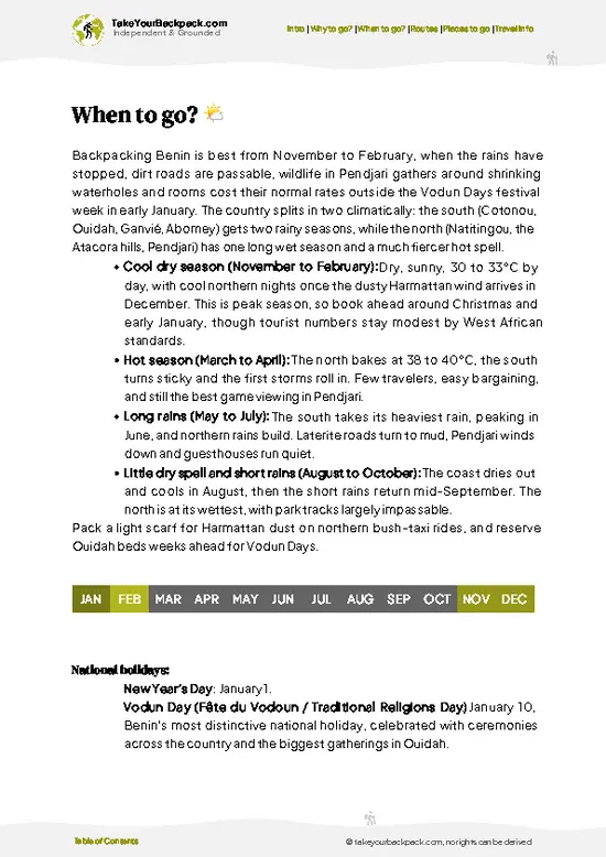
🌤️ When to go?Weather, crowds, and seasonal trade-offs

  • Harmattan (December to February): Mornings in the Atakora hills start cool, around 16 to 20°C (61 to 68°F), and afternoons reach 33 to 36°C (91 to 97°F). Dust haze flattens distant views, but the paths are firm and dry.
  • Late Dry Season (March to April): Peak heat of 36 to 40°C (97 to 104°F) makes midday walking miserable. Start at dawn and rest in the shade of a tata house by noon.
  • Rainy Season (May to September): Highs sit near 28 to 31°C (82 to 88°F). Fields turn green and millet stands tall, yet streams swell, tracks turn to mud and moto taxis struggle. Daylight stays around 12 hours all year.
  • Early Dry Season (October to November): Clear air, green hills and harvest activity make this the most comfortable stretch for walking. Village ceremonies often fall around this time.
Crowds stay thin … read more 👉
  • Harmattan (December to February): Mornings in the Atakora hills start cool, around 16 to 20°C (61 to 68°F), and afternoons reach 33 to 36°C (91 to 97°F). Dust haze flattens distant views, but the paths are firm and dry.
  • Late Dry Season (March to April): Peak heat of 36 to 40°C (97 to 104°F) makes midday walking miserable. Start at dawn and rest in the shade of a tata house by noon.
  • Rainy Season (May to September): Highs sit near 28 to 31°C (82 to 88°F). Fields turn green and millet stands tall, yet streams swell, tracks turn to mud and moto taxis struggle. Daylight stays around 12 hours all year.
  • Early Dry Season (October to November): Clear air, green hills and harvest activity make this the most comfortable stretch for walking. Village ceremonies often fall around this time.
Crowds stay thin year-round, and guide and lodging prices barely move, so book a guide a few days ahead in December and January.


source: climatestotravel.comJANJanuary: excellent for travelingFEBFebruary: excellent for travelingMARMarch: excellent for travelingAPRApril: fair for travelingMAYMay: fair for travelingJUNJune: fair for travelingJULJuly: fair for travelingAUGAugust: fair for travelingSEPSeptember: fair for travelingOCTOctober: fair for travelingNOVNovember: excellent for travelingDECDecember: excellent for traveling
when-to-go

✈️ The backpacker research shortcutBenin Travel Guide

An offline-friendly backpacking guide with optimized travel routes, ranked highlights, transport advice, and the best areas to stay.
example page 0 from our offline Travel Guide for Benin
example page 1 from our offline Travel Guide for Benin
example page 2 from our offline Travel Guide for Benin
example page 3 from our offline Travel Guide for Benin
example page 4 from our offline Travel Guide for Benin
example page 5 from our offline Travel Guide for Benin
example page 6 from our offline Travel Guide for Benin
example page 7 from our offline Travel Guide for Benin
The digital guide (213 pages) contains:
✅ 48 highlights, ranked by travel appeal
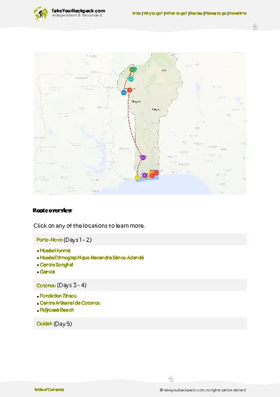
✅ Optimized 5, 10 & 15-day travel routes
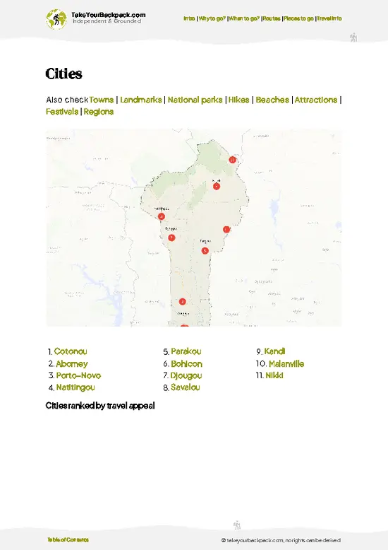
✅ Cities, national parks, landmarks, beaches
✅ How to get around
✅ Offline-friendly for travel without Wi-Fi
👉 Click to see all 30+ guide features

📅 Plan smarter in minutes, not weeks
✅ Month by month travel advice
✅ Festivals & national holidays
✅ Budget expectations

🗺️ Go to the right places, skip the overrated ones
✅ Honest pros & cons of destinations
✅ Top hikes, parks & viewpoints
✅ Lesser-known places most travelers miss
✅ Clear “worth it vs skip it” guidance

🛏️ Travel smoothly without rookie mistakes
✅ Best areas to stay
✅ Transport systems explained simply
✅ Common scams & safety advice
✅ SIM cards, money & practical tips

🌍 Understand the country, not just visit it
✅ Culture & traditions
✅ 52 Essential phrases & customs
✅ Festivals worth planning around
✅ Traveler-friendly historical context
✅ Insights that make places more meaningful

📱 Built for real travel conditions
✅ Fully downloadable PDF
✅ Works completely offline
✅ Optimized for phone use
✅ Useful in remote areas & buses
✅ Everything in one place
Stop searching, start planning
Get instant access to your full guide. 30‑day money-back guarantee.
+ Add another guide for just

By proceeding you agree to our terms.
Sent to your inbox immediately after payment • 100% Secure Checkout
Best Backpacking Travel Advisor 2025 tourism awardBest Backpacking
Travel Advisor
2025
What others say about Take Your Backpack Guides:
⭐⭐⭐⭐⭐
Fantastic, amazing amount of information!
⭐⭐⭐⭐⭐
My goodness this is amazing, it's what I've been looking for hats off too you!
⭐⭐⭐⭐⭐
I think this is absolutely BRILLIANT
⭐⭐⭐⭐
Very complete and informative. It's still missing places, but I gotta to commend you
⭐⭐⭐⭐⭐
This is truly amazing, thank you, can't wait to explore it with my kids!
⭐⭐⭐⭐⭐
Awesome resource, thank you!
⭐⭐⭐⭐⭐
This is amazing! Can't wait to explore the ones I haven't seen
⭐⭐⭐⭐
I love this! Well done, great idea.
⭐⭐⭐⭐⭐
Thanks for taking the time to make this gem!
⭐⭐⭐⭐⭐
This might be the best website I've ever seen.
⭐⭐⭐⭐⭐
Congratulations, and thank you so much for your work; it's incredibly valuable.
⭐⭐⭐⭐
In all seriousness I think you did a great job pointing out the important spots
⭐⭐⭐⭐⭐
10/10 very good
⭐⭐⭐⭐⭐
As someone who's only just starting to visit regularly this is awesome, thank you.
⭐⭐⭐⭐
Thank you very much! I'm going to visit my dad, it's going to be very useful!
⭐⭐⭐⭐⭐
This is really cool! We'll be travelling for the first time and this definitely come in handy.
⭐⭐⭐⭐⭐
You are now our minister of culture, congratulations 👨‍💼
⭐⭐⭐⭐⭐
Just wanted to tell you that this is a pearl! Going to follow your recommendations.
⭐⭐⭐⭐⭐
This is so cool. I'll definitely be using the resource for my travels soon.
⭐⭐⭐⭐⭐
This is very impressive! Good work.
⭐⭐⭐⭐⭐
This is an amazing and informative site. Very well done!

🛏️ Where to stay?Best areas and accommodation options

If you enjoy meeting fellow travelers, consider choosing hostels with high ratings for atmosphere. On the other hand, if you prefer having your own space, a hotel might be a better option.

🥾 Hike detailsEverything you need to know before hiking Somba Country Trek

Total Distance: Somba Country Trek covers roughly 45 kilometers when walked as a three-day route, and shorter loops of 10 to 15 kilometers are easy to carve out.
Estimated Duration: Three days at a steady pace, or a single long day if you only visit the nearest compounds.
Difficulty: Moderate. Climbs are short but steep, the paths are rocky, and the heat is the main challenge from late morning.
Starting Point: Natitingou, the regional hub. Buses and shared taxis arrive here from Cotonou and Parakou. From there, a motorbike taxi or hired car takes you to the village trailheads.
Major Landmarks:
  • Koussoukoingou:
… read more 👉
Total Distance: Somba Country Trek covers roughly 45 kilometers when walked as a three-day route, and shorter loops of 10 to 15 kilometers are easy to carve out.
Estimated Duration: Three days at a steady pace, or a single long day if you only visit the nearest compounds.
Difficulty: Moderate. Climbs are short but steep, the paths are rocky, and the heat is the main challenge from late morning.
Starting Point: Natitingou, the regional hub. Buses and shared taxis arrive here from Cotonou and Parakou. From there, a motorbike taxi or hired car takes you to the village trailheads.
Major Landmarks:
  • Koussoukoingou: A well-preserved Betammaribé village and a common first overnight.
  • Boukoumbé area: Clusters of tata somba on the hillsides, with weekly market activity.
  • Kota Falls: A cooling swim stop near Natitingou.
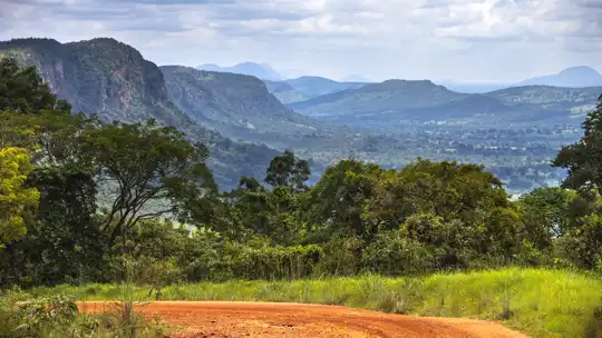
Terrain and Scenery: Rocky footpaths, dry streambeds, terraced millet and sorghum plots, and low granite ridges. The views open wide over the Atakora hills, and the tata somba stand out as dark clay towers among the fields.
Vegetation: Open savanna woodland with shea and néré trees, baobabs, mango groves near villages and fields of millet, yam and cotton. In the dry months the grass turns straw-colored and the haze softens the horizon.
Wildlife: Expect hornbills, bee-eaters, monkeys in the wooded gullies, and lizards sunning on the clay walls. Large mammals live inside Pendjari National Park, not on the trek itself.
Practical Notes: Carry three liters of water, a hat, and cash in small notes. Bring a headlamp, since village lodging has little or no electricity.
⚠️ Hiking info can sometimes be outdated or inaccurate. Before you hit the trail, check the latest conditions with locals. If you do spot anything that's off, I'd love to hear from you, so I can update it for fellow travelers.

🛡️ SafetySafety Tips and Common Scams in Somba Country Trek

Somba Country Trek is a low-risk walk on village paths, with heat and dehydration the main hazards. Between March and April, start at first light, carry at least 3 liters of water per person and stop through the midday peak. Footing is mostly packed earth and rocky stretches over the Atakora hills, so sturdy trail shoes beat sandals. In the rains, paths get slick and streams can run too high to wade, which is when a local guide earns their fee. Trails branch constantly between hamlets and signage is nonexistent, so walk with someone who knows the route. Snakes and scorpions exist, so watch where you put hands and feet, and shake out shoes left outside. Malaria is present, so take prophylaxis and cover up at dusk. Ask before photographing people or entering a tata, and bring small gifts of … read more 👉
Somba Country Trek is a low-risk walk on village paths, with heat and dehydration the main hazards. Between March and April, start at first light, carry at least 3 liters of water per person and stop through the midday peak. Footing is mostly packed earth and rocky stretches over the Atakora hills, so sturdy trail shoes beat sandals. In the rains, paths get slick and streams can run too high to wade, which is when a local guide earns their fee. Trails branch constantly between hamlets and signage is nonexistent, so walk with someone who knows the route. Snakes and scorpions exist, so watch where you put hands and feet, and shake out shoes left outside. Malaria is present, so take prophylaxis and cover up at dusk. Ask before photographing people or entering a tata, and bring small gifts of kola or cash for hosts. Cell coverage is patchy, so tell your guesthouse your plan.

FAQTraveler FAQ

Somba Country Trek takes 2 to 4 days on foot, covering roughly 10 to 20 km of village paths per day. Many travelers base themselves in Boukoumbé or Natitingou and do a single day loop of 4 to 6 hours. Longer versions overnight in villagers' homes or campements near the Togo border.
Somba Country Trek is easy to moderate, with no technical sections and no high altitude. The challenge comes from heat of up to 40°C (104°F) in March and April and from rocky, undulating hill paths. Most reasonably fit walkers manage 15 km a day if they start early and carry enough water.
Somba Country Trek has no formal permit system, but a local guide is strongly recommended because paths between hamlets are unmarked. Guides from Natitingou or Boukoumbé usually charge about €15 to 30 a day, and a visit to a village may add a small contribution of €2 to 5. Bring your passport and yellow fever certificate, since police checkpoints are common on the roads in northwest Benin.
⚠️ Things can change over time, so always validate details locally before you go.

Other Beninese hikes near Somba Country Trek

Explore more nearby:


💡 Not sure where to go next?
Create a personalized itinerary for Benin including Somba Country Trek and the places that fit your trip.

Generate my itinerary

👉 Discover all hikes

Or checkout all Benin has to offer (think cities, towns, villages, national parks, hikes, beaches, festivals)
Country photo of Benin

We 💚 feedbackIs it worth it?

Somba Country Trek hides its best moment in the granary roofs. Ask your host to explain how each round tower is assigned to a family member, and why the roof is sealed the way it is. That conversation turns a pretty clay house into a working system. I would bring a small gift of salt or school pencils for your host, and walk early.

✍️ Help improve this page!
The information on this page is based on in-depth research, insights shared by experienced travelers, and feedback from the local travel community in Benin. While every effort is made to keep the information accurate and current, conditions can change — so if you spot anything incorrect or outdated, please get in touch.


🙋‍♂️ Give feedback

👋 Meet the founderWho’s Behind Take Your Backpack?

Johan, backpacker and founder of TakeYourBackpackHi, I’m Johan (Netherlands 🇳🇱), the creator of TakeYourBackpack. Over the past 3 decades, I’ve backpacked through 90+ countries across six continents, gaining extensive experience with independent travel, long-term trips, and overland routes.

This site is built on a combination of firsthand travel experience and carefully curated insights from other backpackers. Many guides are based on places I’ve personally visited, while others bring together tips, observations, and practical advice shared by trusted travelers I’ve met along the way.

The goal is to provide realistic, experience-driven guidance — not generic itineraries — so you can explore destinations with better context, clearer expectations, and more confidence.