- Cerro Tronador panorama — The giant, glaciated massif dominates the whole walk; its snow-and-ice silhouette changes color with the light and gives the trail that “you’re actually in the Andes” feeling. This volcanic backdrop is what separates Pampa Linda from ordinary forest hikes — everything frames back to that dramatic peak.
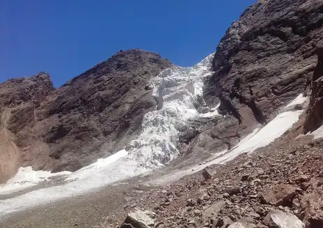
- Ventisquero Castaño Overa (glacier front) — Up close to a real glacier: blue ice faces, crevasses and the occasional crack or small calving into the melt streams. It’s unusually accessible for a Patagonian glacier, so you get the spectacle without a full mountaineering commit. (Personal favorite — there’s nothing like that first sight of the ice wall.)
- Mossy lenga forest — Thick, old-growth lenga beech draped in moss and lichens gives long stretches of the trail
- Cerro Tronador panorama — The giant, glaciated massif dominates the whole walk; its snow-and-ice silhouette changes color with the light and gives the trail that “you’re actually in the Andes” feeling. This volcanic backdrop is what separates Pampa Linda from ordinary forest hikes — everything frames back to that dramatic peak.
- Ventisquero Castaño Overa (glacier front) — Up close to a real glacier: blue ice faces, crevasses and the occasional crack or small calving into the melt streams. It’s unusually accessible for a Patagonian glacier, so you get the spectacle without a full mountaineering commit. (Personal favorite — there’s nothing like that first sight of the ice wall.)
- Mossy lenga forest — Thick, old-growth lenga beech draped in moss and lichens gives long stretches of the trail a quiet, primeval vibe. The contrast between this emerald understory and the high, stony alpine above is one of the hike’s most memorable textures — feels like two different worlds stitched together.
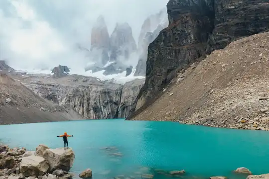
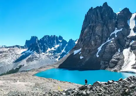
- Cascading rivers and turquoise pools — Meltwater streams and waterfalls tumble through the valley, carving polished rocks and bright, glacial-colored pools. The soundscape (constant tumbling water) and those unreal colors make for great rest stops and photo ops — plus the water is impressively clear when you need to top up your bottle.
- Pampa Linda meadow & alpine viewpoints — The open meadow area itself is worth lingering in: wide skies, wildflowers in season, and several easy vantage points for sunrises or evening light on the glaciers. It’s the sort of place where you can spread out a pack, watch raptors circle, and actually feel like you’ve earned the view.
Spotted a mistake or missing something? Contact us.


 Best Backpacking


.jpg) Hi, I’m Johan (Netherlands 🇳🇱), the creator of TakeYourBackpack. Over the past decade, I’ve backpacked through 80+ countries across six continents, gaining extensive experience with independent travel, long-term trips, and overland routes.
Hi, I’m Johan (Netherlands 🇳🇱), the creator of TakeYourBackpack. Over the past decade, I’ve backpacked through 80+ countries across six continents, gaining extensive experience with independent travel, long-term trips, and overland routes.