×

Guatemala🇬🇹 | hikesEl Mirador TrekPetén jungle, La Danta, mule trail, howler monkeys | things to do and best time to go

Explore Mirador de la CruzExplore Todos Santos Cuchumatán

Backpacking in El Mirador Trek
🌟 Highlighthike ranked #3
By Johan Kruseman 🇳🇱 | Updated October 22, 2026

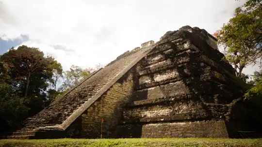
The jungle trail to El Mirador is one of the few multi-day treks in the Americas where you can walk to a pyramid taller than most Maya temples in Tikal, and you will likely share the path with mules, not crowds. El Mirador Trek runs through the Petén rainforest in the far north of Guatemala, starting from the village of Carmelita. Expect about 60 kilometers one way, mud for much of the wet months, and a guide-and-camp setup you must book in advance. The public transport side is the weak point: reach Flores, then a rough shuttle or pickup to Carmelita. I arrived at the first camp as howler monkeys started a roar that rolled through the trees like distant engines, and the air smelled of wet leaves and woodsmoke. Then La Danta rose out of the canopy. Big views, big effort. Fit, patient hikers who like rustic camping will love it. If you hate bugs, mud, or fixed itineraries, skip it.

Discover everything you want to know in the 📖 Guatemala Travel Guide.
Best time to go: November - April
Duration: 5 days
Distance: 120 kilometers
Total ascent: 800 meters


example page 0 from our offline Travel Guide for Guatemala
example page 1 from our offline Travel Guide for Guatemala
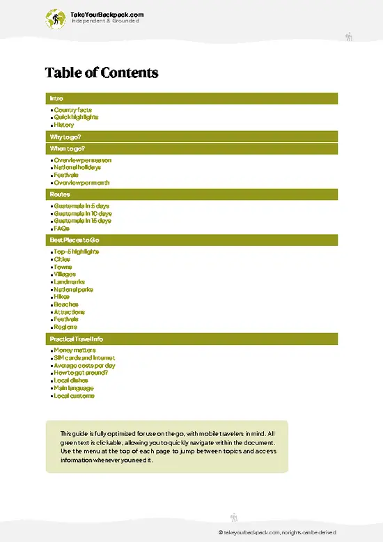
example page 2 from our offline Travel Guide for Guatemala
example page 3 from our offline Travel Guide for Guatemala
example page 4 from our offline Travel Guide for Guatemala
example page 5 from our offline Travel Guide for Guatemala
example page 6 from our offline Travel Guide for Guatemala
example page 7 from our offline Travel Guide for Guatemala
Loading the map 🌍
CLICK TO FILTER
cities
towns
villages
landmarks
national parks
hikes
beaches
attractions
festivals
regions
SHOW COUNTRY’S BESTSHOW ALL

✨ Why go?
Ranked #3 hike in Guatemala
Why visitors keep coming back

El Mirador Trek rewards backpackers with something Tikal no longer offers: ruins you can reach on foot, with long stretches of forest to yourself. The payoff is La Danta, among the largest pyramids by volume ever built anywhere, and you climb it for a sunrise view over an unbroken green canopy where the tops of Calakmul’s pyramids in Mexico sometimes show on the horizon.

The route also works as a real expedition without needing technical skill. The trail is mostly flat, and the Carmelita starting point is a community-run village where local guides, cooks and mule handlers earn directly from your trip, so your money stays in the area. Distances are flexible too. Many travelers do the classic four to six days with a loop back, while others add side visits to sites like Nakbé, El Tintal or Wakná … read more 👉
El Mirador Trek rewards backpackers with something Tikal no longer offers: ruins you can reach on foot, with long stretches of forest to yourself. The payoff is La Danta, among the largest pyramids by volume ever built anywhere, and you climb it for a sunrise view over an unbroken green canopy where the tops of Calakmul’s pyramids in Mexico sometimes show on the horizon.

The route also works as a real expedition without needing technical skill. The trail is mostly flat, and the Carmelita starting point is a community-run village where local guides, cooks and mule handlers earn directly from your trip, so your money stays in the area. Distances are flexible too. Many travelers do the classic four to six days with a loop back, while others add side visits to sites like Nakbé, El Tintal or Wakná along the way.

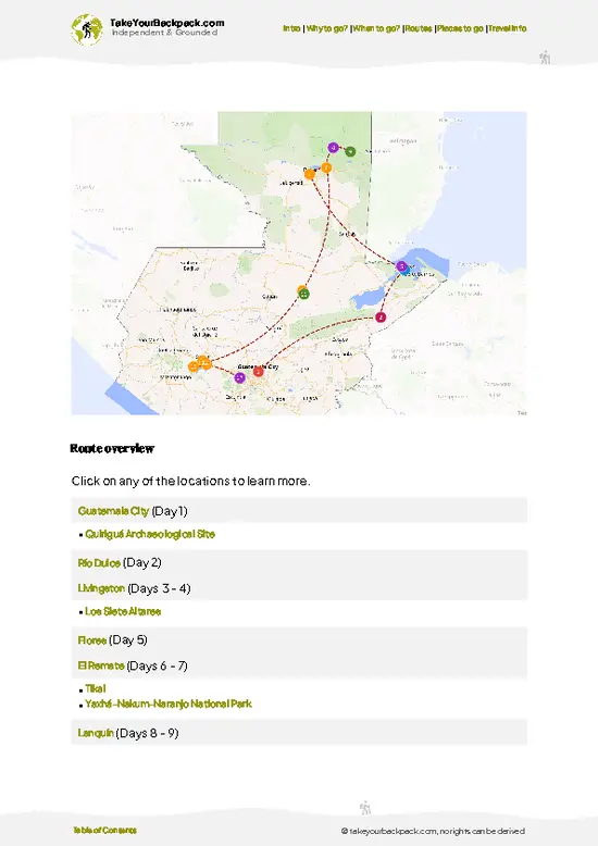
It fits neatly into a longer Guatemala route: a few days around Flores and Lake Petén Itzá beforehand, then Tikal or the Belize border afterward. You get a physical challenge, ancient ruins, and wildlife in the same trip.

💡 HighlightsDon't-miss highlights and experiences

  1. La Danta Pyramid: The headline sight, a massive complex rising about 72 meters above the forest floor, built on a raised platform. Climb the top for a wide, unbroken canopy view, and stay for sunrise if your guide allows an overnight.
  2. El Tigre Pyramid: A second huge temple in the western group, around 55 meters tall. Its side stairs let you climb for another high outlook, and its triadic layout is a clear example of Preclassic Maya design.
  3. Jungle Wildlife Along the Trail: Spider monkeys, howlers, toucans, coatis and sometimes peccaries or ocelot tracks appear along the route. Dawn and dusk give the best chances, and the howlers will wake you anyway.
  4. Stucco Masks at Nakbé and Nearby Sites: Side trips on some itineraries reach Preclassic sites with huge carved stucco masks and early monumental
… read more 👉
  1. La Danta Pyramid: The headline sight, a massive complex rising about 72 meters above the forest floor, built on a raised platform. Climb the top for a wide, unbroken canopy view, and stay for sunrise if your guide allows an overnight.
  2. El Tigre Pyramid: A second huge temple in the western group, around 55 meters tall. Its side stairs let you climb for another high outlook, and its triadic layout is a clear example of Preclassic Maya design.
  3. Jungle Wildlife Along the Trail: Spider monkeys, howlers, toucans, coatis and sometimes peccaries or ocelot tracks appear along the route. Dawn and dusk give the best chances, and the howlers will wake you anyway.
  4. Stucco Masks at Nakbé and Nearby Sites: Side trips on some itineraries reach Preclassic sites with huge carved stucco masks and early monumental building. They show how old the Mirador Basin civilization is.
  5. Carmelita and Community Camps: The village at the start has a small community scene, with local guides and cooks preparing your supplies. Camps on the route, such as at La Florida, give a simple but memorable overnight base.
Do La Danta first, ideally at sunrise, because the view is the whole reason you walked here and it is clearest before heat haze builds.
Spotted a mistake or missing something? Contact us.

Things to do around El Mirador Trek

Ratings based on Tripadvisor reviews. When you book through this link, you support our work at no extra cost to you.

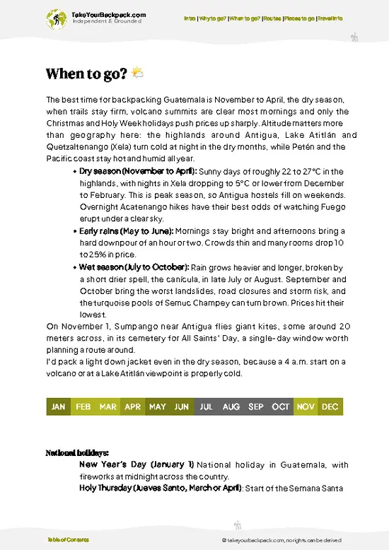
🌤️ When to go?Seasonal considerations and timing

  • Dry Season (February to May): This is the most dependable window for El Mirador Trek, with mud at its lowest on the 5 to 6 day round trip from Carmelita. Days reach 30 to 36°C (86 to 97°F) in the forest, and nights drop to 20 to 23°C (68 to 73°F). Water sources thin out by April and May, so carry more.
  • Early Dry Season (December to January): Cooler at 24 to 30°C (75 to 86°F) by day, with nights near 15 to 20°C (59 to 68°F). Trails are mostly firm, and this is peak season for tour groups and prices.
  • Wet Season (June to November): Daily downpours turn the clay trail into knee-deep mud in places, and the route can become impassable. Many operators run fewer departures or stop altogether between September and November. Prices drop, and you may have camps almost to yourself.
Daylight stays at about … read more 👉
  • Dry Season (February to May): This is the most dependable window for El Mirador Trek, with mud at its lowest on the 5 to 6 day round trip from Carmelita. Days reach 30 to 36°C (86 to 97°F) in the forest, and nights drop to 20 to 23°C (68 to 73°F). Water sources thin out by April and May, so carry more.
  • Early Dry Season (December to January): Cooler at 24 to 30°C (75 to 86°F) by day, with nights near 15 to 20°C (59 to 68°F). Trails are mostly firm, and this is peak season for tour groups and prices.
  • Wet Season (June to November): Daily downpours turn the clay trail into knee-deep mud in places, and the route can become impassable. Many operators run fewer departures or stop altogether between September and November. Prices drop, and you may have camps almost to yourself.
Daylight stays at about 12 hours all year, so plan on early starts to finish hiking before the afternoon heat. Book your group departure at least a few weeks ahead for February through April.


source: climatestotravel.comJANJanuary: excellent for travelingFEBFebruary: excellent for travelingMARMarch: excellent for travelingAPRApril: highly recommended for travelingMAYMay: fair for travelingJUNJune: fair for travelingJULJuly: fair for travelingAUGAugust: fair for travelingSEPSeptember: fair for travelingOCTOctober: fair for travelingNOVNovember: highly recommended for travelingDECDecember: excellent for traveling
guatemala-hike-el-mirador-trek
© Google |

✈️ The backpacker research shortcutGuatemala Travel Guide

An offline-friendly backpacking guide with optimized travel routes, ranked highlights, transport advice, and the best areas to stay.
example page 0 from our offline Travel Guide for Guatemala
example page 1 from our offline Travel Guide for Guatemala
example page 2 from our offline Travel Guide for Guatemala
example page 3 from our offline Travel Guide for Guatemala
example page 4 from our offline Travel Guide for Guatemala
example page 5 from our offline Travel Guide for Guatemala
example page 6 from our offline Travel Guide for Guatemala
example page 7 from our offline Travel Guide for Guatemala
The digital guide (272 pages) contains:
✅ 85 highlights, ranked by travel appeal
✅ Optimized 5, 10 & 15-day travel routes
✅ Cities, national parks, landmarks, beaches
✅ How to get around
✅ Offline-friendly for travel without Wi-Fi
👉 Click to see all 30+ guide features

📅 Plan smarter in minutes, not weeks
✅ Month by month travel advice
✅ Festivals & national holidays
✅ Budget expectations

🗺️ Go to the right places, skip the overrated ones
✅ Honest pros & cons of destinations
✅ Top hikes, parks & viewpoints
✅ Lesser-known places most travelers miss
✅ Clear “worth it vs skip it” guidance

🛏️ Travel smoothly without rookie mistakes
✅ Best areas to stay
✅ Transport systems explained simply
✅ Common scams & safety advice
✅ SIM cards, money & practical tips

🌍 Understand the country, not just visit it
✅ Culture & traditions
✅ 52 Essential phrases & customs
✅ Festivals worth planning around
✅ Traveler-friendly historical context
✅ Insights that make places more meaningful

📱 Built for real travel conditions
✅ Fully downloadable PDF
✅ Works completely offline
✅ Optimized for phone use
✅ Useful in remote areas & buses
✅ Everything in one place
Stop searching, start planning
Get instant access to your full guide. 30‑day money-back guarantee.
+ Add another guide for just

By proceeding you agree to our terms.
Sent to your inbox immediately after payment • 100% Secure Checkout
Best Backpacking Travel Advisor 2025 tourism awardBest Backpacking
Travel Advisor
2025
What others say about Take Your Backpack Guides:
⭐⭐⭐⭐⭐
Fantastic, amazing amount of information!
⭐⭐⭐⭐⭐
My goodness this is amazing, it's what I've been looking for hats off too you!
⭐⭐⭐⭐⭐
I think this is absolutely BRILLIANT
⭐⭐⭐⭐
Very complete and informative. It's still missing places, but I gotta to commend you
⭐⭐⭐⭐⭐
This is truly amazing, thank you, can't wait to explore it with my kids!
⭐⭐⭐⭐⭐
Awesome resource, thank you!
⭐⭐⭐⭐⭐
This is amazing! Can't wait to explore the ones I haven't seen
⭐⭐⭐⭐
I love this! Well done, great idea.
⭐⭐⭐⭐⭐
Thanks for taking the time to make this gem!
⭐⭐⭐⭐⭐
This might be the best website I've ever seen.
⭐⭐⭐⭐⭐
Congratulations, and thank you so much for your work; it's incredibly valuable.
⭐⭐⭐⭐
In all seriousness I think you did a great job pointing out the important spots
⭐⭐⭐⭐⭐
10/10 very good
⭐⭐⭐⭐⭐
As someone who's only just starting to visit regularly this is awesome, thank you.
⭐⭐⭐⭐
Thank you very much! I'm going to visit my dad, it's going to be very useful!
⭐⭐⭐⭐⭐
This is really cool! We'll be travelling for the first time and this definitely come in handy.
⭐⭐⭐⭐⭐
You are now our minister of culture, congratulations 👨‍💼
⭐⭐⭐⭐⭐
Just wanted to tell you that this is a pearl! Going to follow your recommendations.
⭐⭐⭐⭐⭐
This is so cool. I'll definitely be using the resource for my travels soon.
⭐⭐⭐⭐⭐
This is very impressive! Good work.
⭐⭐⭐⭐⭐
This is an amazing and informative site. Very well done!

🛏️ Where to stay?Where staying makes the most sense

If you enjoy meeting fellow travelers, consider choosing hostels with high ratings for atmosphere. On the other hand, if you prefer having your own space, a hotel might be a better option.

🥾 Hike detailsRoute, distance, and difficulty explained

Total Distance: El Mirador Trek covers roughly 60 kilometers one way from Carmelita, so about 110 to 120 kilometers as a round trip with side visits.
Estimated Duration: Most groups take 4 to 6 days, with the longer itineraries adding extra ruins.
Difficulty: Moderate to hard. The terrain is mostly flat, but the length, heat and deep mud in the rainy months make it tiring.
Starting Point: Carmelita, a village reached from Flores by shuttle or pickup truck over a rough road. Public transport is limited, so most hikers arrange transport through their tour operator.
Major Landmarks:
  • La Florida: A common
… read more 👉
Total Distance: El Mirador Trek covers roughly 60 kilometers one way from Carmelita, so about 110 to 120 kilometers as a round trip with side visits.
Estimated Duration: Most groups take 4 to 6 days, with the longer itineraries adding extra ruins.
Difficulty: Moderate to hard. The terrain is mostly flat, but the length, heat and deep mud in the rainy months make it tiring.
Starting Point: Carmelita, a village reached from Flores by shuttle or pickup truck over a rough road. Public transport is limited, so most hikers arrange transport through their tour operator.
Major Landmarks:
  • La Florida: A common camp and rest stop along the early section.
  • El Tintal: An extensive Preclassic site often visited on the way.
  • Nakbé: Early Maya ruins with large stucco masks.
  • La Danta and El Tigre: The main pyramid groups at the destination.
Terrain and Scenery: Wide forest tracks, low limestone ridges, seasonal swampy flats called bajos, and views from pyramid summits across the canopy.
Vegetation: Tropical lowland rainforest with mahogany, sapodilla, ramón trees and thick understory. Palms line damp patches.
Wildlife: Howler and spider monkeys, toucans, parrots, ocellated turkeys, snakes and plenty of insects. Jaguars exist but are rarely seen.
⚠️ Hiking info can sometimes be outdated or inaccurate. Before you hit the trail, check the latest conditions with locals. If you do spot anything that's off, I'd love to hear from you, so I can update it for fellow travelers.

🛡️ SafetyScams, Hazards, and Annoyances

El Mirador Trek is a remote jungle route of roughly 60 km (37 miles) each way, and the main hazards are heat, mud and distance from help. You are in lowland rainforest with no road access, so go with a licensed operator who carries a radio or satellite device and a first aid kit. Start walking at dawn and rest through the hottest hours. Drink steadily, add electrolytes, and treat or filter all water. Boots with good tread matter in the wet months, when clay turns slick and ankles roll easily. Wildlife includes spider monkeys, coatis, snakes, ticks and the occasional jaguar sighting. Give animals space, never feed them, keep food sealed in camp, and shake out boots each morning. Wear long sleeves and apply insect repellent against mosquitoes and biting flies. Stay behind your guide on forks, … read more 👉
El Mirador Trek is a remote jungle route of roughly 60 km (37 miles) each way, and the main hazards are heat, mud and distance from help. You are in lowland rainforest with no road access, so go with a licensed operator who carries a radio or satellite device and a first aid kit. Start walking at dawn and rest through the hottest hours. Drink steadily, add electrolytes, and treat or filter all water. Boots with good tread matter in the wet months, when clay turns slick and ankles roll easily. Wildlife includes spider monkeys, coatis, snakes, ticks and the occasional jaguar sighting. Give animals space, never feed them, keep food sealed in camp, and shake out boots each morning. Wear long sleeves and apply insect repellent against mosquitoes and biting flies. Stay behind your guide on forks, because side trails are easy to miss. First-timers often under-pack socks and underestimate how tiring the trail humidity is.

FAQFrequently asked questions about El Mirador Trek

The El Mirador Trek takes 4 to 6 days round trip on foot, covering about 120 km (75 miles) from the village of Carmelita. Most groups reach the La Danta pyramid on day 3 for sunrise or midday and return by the same trail. Helicopter day tours from Flores, with flights of 35 minutes to an hour each way, cut the trip to a single day for roughly US$600 to 800 per person.
El Mirador Trek is moderately to very demanding, mainly because of heat, humidity and mud rather than technical terrain. You walk 20 to 25 km (12 to 15 miles) a day on flat to gently rolling forest tracks, with a final climb up La Danta, which rises about 70 meters (230 feet). In the wet season, deep mud adds hours and makes it considerably harder, so good fitness is needed.
Yes, you need a licensed guide for El Mirador Trek, since independent hiking is not permitted in practice and the trail is long and poorly marked. Guided 5 to 6 day trips from Flores or Carmelita cost about US$350 to 600 per person, covering food, mules for gear, camping and the park entry fee. Entry fees are paid in quetzales, and the operator usually handles them.
⚠️ Things can change over time, so always validate details locally before you go.

Other Guatemalan hikes near El Mirador Trek

Explore more nearby:


💡 Not sure where to go next?
Create a personalized itinerary for Guatemala including El Mirador Trek and the places that fit your trip.

Generate my itinerary

👉 Discover all hikes

Or checkout all Guatemala has to offer (think cities, towns, villages, national parks, hikes, beaches, festivals)
Country photo of Guatemala

We 💚 feedbackParting advice and final tips

El Mirador Trek deserves at least five days, and I would take six if you want side ruins without rushing. Shorter versions exist, but the walking eats most of the time. I would pack breathable clothes, insect repellent and spare socks, then book a community-run outfitter in Flores well ahead.

✈️ When did I visit Guatemala?
Guatemala I visited during my half year trip through South and Central America back in 2003

✍️ Help improve this page!
The information on this page is based on my own backpacking experience in Guatemala, supplemented with up-to-date research and feedback from other travelers. Travel details can change, so if you notice anything outdated or incomplete, feel free to let me know.


🙋‍♂️ Give feedback

👋 Meet the founderWho’s Behind Take Your Backpack?

Johan, backpacker and founder of TakeYourBackpackHi, I’m Johan (Netherlands 🇳🇱), the creator of TakeYourBackpack. Over the past 3 decades, I’ve backpacked through 90+ countries across six continents, gaining extensive experience with independent travel, long-term trips, and overland routes.

This site is built on a combination of firsthand travel experience and carefully curated insights from other backpackers. Many guides are based on places I’ve personally visited, while others bring together tips, observations, and practical advice shared by trusted travelers I’ve met along the way.

The goal is to provide realistic, experience-driven guidance — not generic itineraries — so you can explore destinations with better context, clearer expectations, and more confidence.