


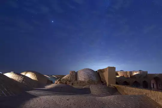
- Salasel Fortress (the hydraulic fortress) — The control hub of the whole system: a compact complex of sluices, reservoirs, watchtowers and access passages that shows how military, urban and water-management needs were fused in one place. Walk its terraces to see how engineers directed flows and defended the city at the same time.
- Band-e Kaisar (the Dam-Bridge) — A rare example of a dam built like a bridge, traditionally attributed to Roman engineers working under Sassanid rule. It’s striking to see masonry that both holds back water and supports crossing traffic — engineering you can actually stroll across and photograph.
- Gargar Canal and island landscape — The main man-made artery that turns the Karun into a pocketed, island-filled town. Follow its banks to appreciate how the canal carves
- Salasel Fortress (the hydraulic fortress) — The control hub of the whole system: a compact complex of sluices, reservoirs, watchtowers and access passages that shows how military, urban and water-management needs were fused in one place. Walk its terraces to see how engineers directed flows and defended the city at the same time.
- Band-e Kaisar (the Dam-Bridge) — A rare example of a dam built like a bridge, traditionally attributed to Roman engineers working under Sassanid rule. It’s striking to see masonry that both holds back water and supports crossing traffic — engineering you can actually stroll across and photograph.
- Gargar Canal and island landscape — The main man-made artery that turns the Karun into a pocketed, island-filled town. Follow its banks to appreciate how the canal carves Shushtar’s unique urban pattern and creates photogenic little waterfalls and riverfront lanes.
- Historic watermills and millworks — A cluster of intact mills and millraces powered directly by the diverted stream. They’re not just quaint — they show the ingenious conversion of hydraulic power into daily industry, still readable in the stone channels and wheel housings.
- Underground channels, tunnels and shafts — Cut passages and controlled siphons that route water under streets and fields. Crawling viewpoints into these tunnels (from safe vantage points) gives you a real sense of the hidden complexity that makes the whole system work.
- Irrigation network and agricultural logic — The far-reaching distributary ditches and sluices that made agriculture reliably productive for centuries. Look at the pattern of fields and terraces — the system’s social and economic purpose becomes obvious here.
- Everyday life, bazaar edges and sunset views — The hydraulic system isn’t just ruins; it shapes local life. Walk the riverfront near the bazaar at golden hour, watch kids play by the edge, and you’ll see how the living town and ancient engineering coexist — plus it’s the best time for silhouettes of dams and bridges.
Spotted a mistake or missing something? Contact us.

 Best Backpacking
 Hi, I’m Johan (Netherlands 🇳🇱), the creator of TakeYourBackpack. Over the past 3 decades, I’ve backpacked through 90+ countries across six continents, gaining extensive experience with independent travel, long-term trips, and overland routes.