×

Liechtenstein🇱🇮 | hikesMalbun to SareisSareis alpine restaurant, Sareiserjoch saddle, Augstenberg summit, Valüna meadows | things to do and best time to go

Explore Drei-Schwestern-SteigExplore Rappenstein

Backpacking in Malbun to Sareis
👍 Recommendedhike ranked #3
By Johan Kruseman 🇳🇱 | Updated November 6, 2026

Malbun to Sareis is a short ridge and pasture walk above the ski resort, best done as a loop. It sits in the south-east of Liechtenstein, in the Malbun side valley above Steg. Scenery is the draw: open meadows, the Sareiser Joch ridge and a wide sweep of the Rätikon. Difficulty is easy to moderate, though the final climb to the ridge is steep. Public transport is simple, since the bus from Vaduz climbs to Malbun and the trail starts right behind the village. Costs catch people out: the chairlift up to Sareis is pricey, so walk up if your legs are fresh. Delays happen when afternoon cloud rolls in, so start by mid-morning. Unlike the Fürstensteig, which is exposed and demanding, this one is gentle and family friendly.

Part of Backpacking in Liechtenstein: all 25 places on one map, with routes and the best time to go.
Discover everything you want to know in the 📖 Liechtenstein Travel Guide.
Best time to go: April - October
Duration: 3 hours
Distance: 8 kilometers
Total ascent: 350 meters
Loading the map 🌍
CLICK TO FILTER
towns
villages
landmarks
hikes
attractions
festivals
regions
SHOW COUNTRY’S BESTSHOW ALL

✨ Why go?
Ranked #3 hike in Liechtenstein
What makes this hike worth hiking

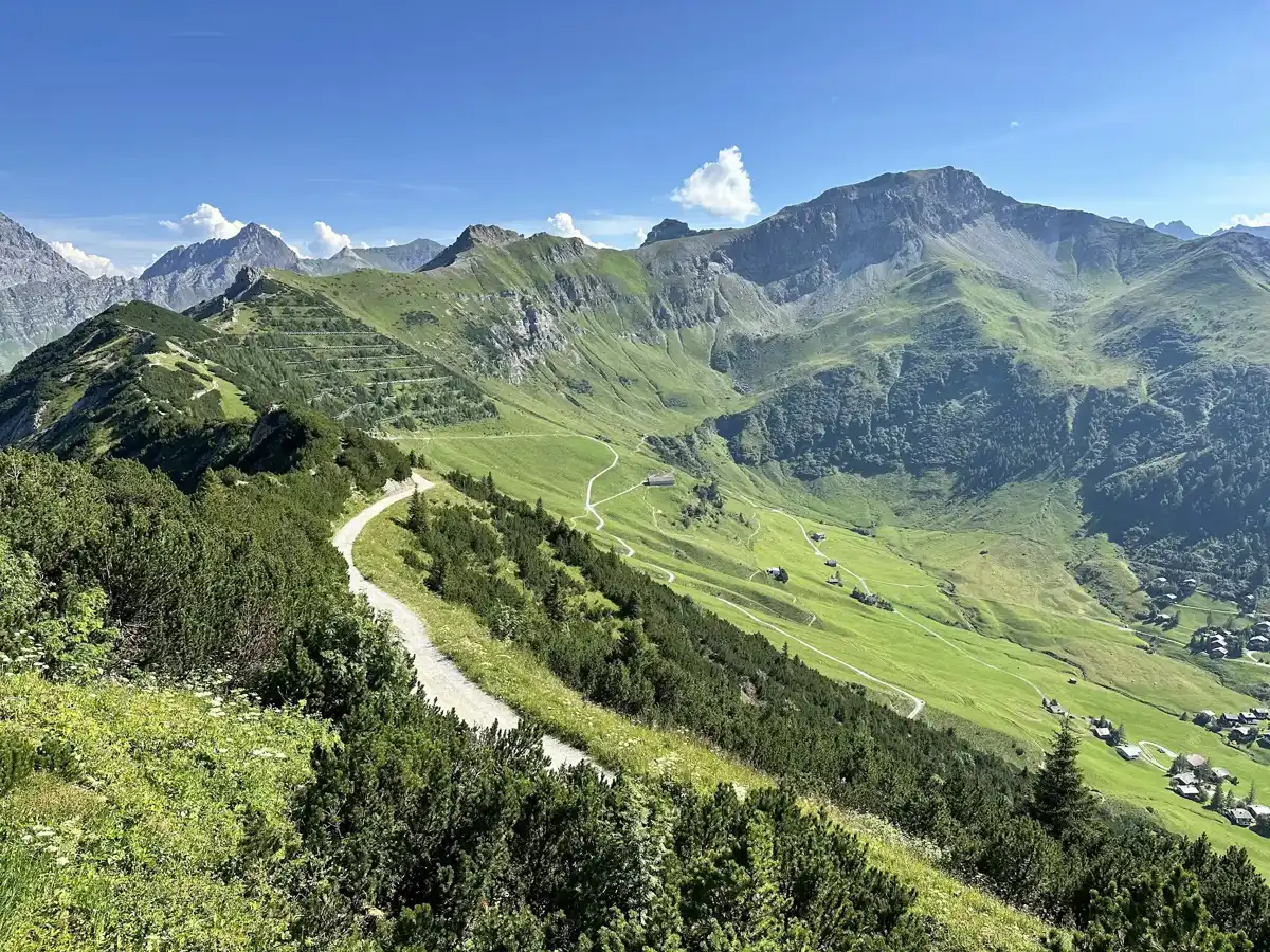
Malbun to Sareis gives you a high-alpine feel on a morning’s outing, which is rare in a country this small. You start at roughly 1,600 meters, so the climb is only a few hundred meters, yet you end up among the Sareiserjoch ridge line looking across the Rätikon toward Switzerland and Austria. Nothing technical stands in your way, so it works on a rest day between harder hikes or as a first taste of mountain walking.
The second draw is how easily it ties into a Liechtenstein itinerary. A regular public bus climbs from Vaduz, so you can leave your pack at a hostel in the valley and walk with a light daypack. From Sareis you can extend toward Augstenberg at 2,359 meters or loop back through the Valüna valley, which lets you stretch the day to what your legs want. Because the country is tiny, a … read more 👉
Malbun to Sareis gives you a high-alpine feel on a morning’s outing, which is rare in a country this small. You start at roughly 1,600 meters, so the climb is only a few hundred meters, yet you end up among the Sareiserjoch ridge line looking across the Rätikon toward Switzerland and Austria. Nothing technical stands in your way, so it works on a rest day between harder hikes or as a first taste of mountain walking.
The second draw is how easily it ties into a Liechtenstein itinerary. A regular public bus climbs from Vaduz, so you can leave your pack at a hostel in the valley and walk with a light daypack. From Sareis you can extend toward Augstenberg at 2,359 meters or loop back through the Valüna valley, which lets you stretch the day to what your legs want. Because the country is tiny, a single early start leaves time to cross into Switzerland or Austria the same evening.

💡 HighlightsTop highlights of Malbun to Sareis

  1. Sareis and its mountain restaurant: The hike’s namesake and its natural stopping point, set on open alpine pasture high above Malbun. Cows graze nearby in summer, and a terrace lets you sit with the whole valley below you.
  2. Sareiserjoch viewpoint: The saddle above Sareis opens the horizon to the Rätikon range and across the border. On a clear day the ridges pile up in layers, and it is the best photo spot of the walk.
  3. Augstenberg: At 2,359 meters this is the obvious summit for anyone with extra energy. The path is steep in places, but the reward is a wide panorama over the Liechtenstein Alps and down into the Rhine valley.
  4. Valüna valley: The valley that runs south from Steg, west of Malbun, with meadows, scattered huts and quiet trails. Alpine flowers peak in early summer, and marmots and chamois
… read more 👉
  1. Sareis and its mountain restaurant: The hike’s namesake and its natural stopping point, set on open alpine pasture high above Malbun. Cows graze nearby in summer, and a terrace lets you sit with the whole valley below you.
  2. Sareiserjoch viewpoint: The saddle above Sareis opens the horizon to the Rätikon range and across the border. On a clear day the ridges pile up in layers, and it is the best photo spot of the walk.
  3. Augstenberg: At 2,359 meters this is the obvious summit for anyone with extra energy. The path is steep in places, but the reward is a wide panorama over the Liechtenstein Alps and down into the Rhine valley.
  4. Valüna valley: The valley that runs south from Steg, west of Malbun, with meadows, scattered huts and quiet trails. Alpine flowers peak in early summer, and marmots and chamois are often spotted on the slopes.
  5. Malbun village: Not pretty, but handy. It is the start point, with lift stations, cafés and a small cluster of guesthouses where you can grab a coffee before the climb. Look for the chairlifts that link it to the high ridges.
Malbun to Sareis takes about half a day with all five stops, and a full day if you add the Augstenberg summit.
Spotted a mistake or missing something? Contact us.

Things to do near Malbun to Sareis

Ratings based on Tripadvisor reviews. When you book through this link, you support our work at no extra cost to you.

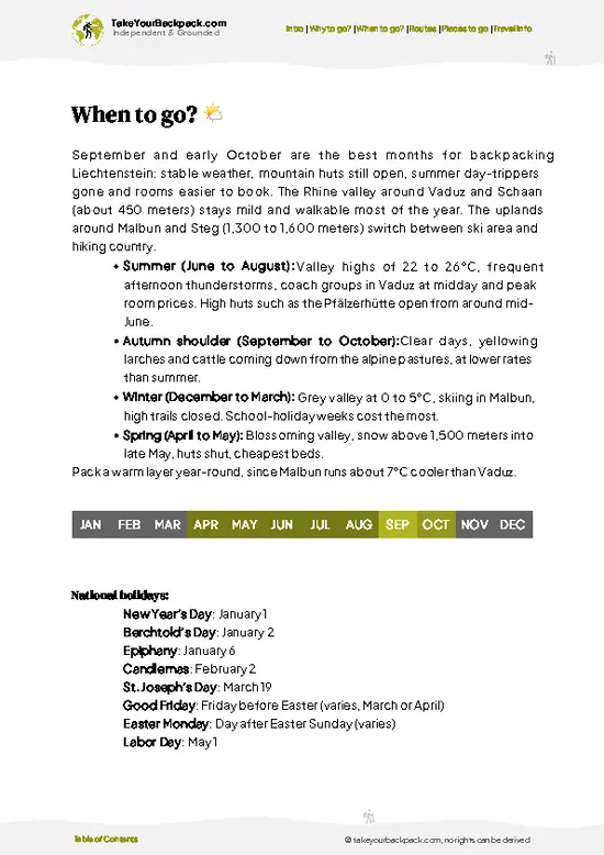
🌤️ When to go?Seasonal considerations and timing

  • Summer (late June to early September): Peak hiking window, with daytime highs of 12 to 20°C (54 to 68°F), cool mornings near 5°C (41°F) and about 15 hours of daylight in June. Afternoon thunderstorms are common, so start early. Weekends bring the most families, and lodging in Malbun is at its busiest.
  • Early autumn (September to mid-October): Crisp, clear air at 5 to 14°C (41 to 57°F), larch needles turning gold and far fewer people. Daylight drops to about 11 hours by mid-October, and the chairlift may stop running.
  • Winter (December to March): Temperatures sit between -8 and 0°C (18 to 32°F). Malbun is a ski area, so expect snow, packed winter paths and the highest prices, especially at weekends and school holidays. Daylight is about 8.5 hours.
  • Spring (April to early June): Snowmelt leaves slush
… read more 👉
  • Summer (late June to early September): Peak hiking window, with daytime highs of 12 to 20°C (54 to 68°F), cool mornings near 5°C (41°F) and about 15 hours of daylight in June. Afternoon thunderstorms are common, so start early. Weekends bring the most families, and lodging in Malbun is at its busiest.
  • Early autumn (September to mid-October): Crisp, clear air at 5 to 14°C (41 to 57°F), larch needles turning gold and far fewer people. Daylight drops to about 11 hours by mid-October, and the chairlift may stop running.
  • Winter (December to March): Temperatures sit between -8 and 0°C (18 to 32°F). Malbun is a ski area, so expect snow, packed winter paths and the highest prices, especially at weekends and school holidays. Daylight is about 8.5 hours.
  • Spring (April to early June): Snowmelt leaves slush and closed paths, with 0 to 10°C (32 to 50°F). Most businesses pause between seasons.
Go in July or September on a weekday for dry trails, long light and a quiet path.


source: climatestotravel.comJANJanuary: below average for travelingFEBFebruary: below average for travelingMARMarch: fair for travelingAPRApril: highly recommended for travelingMAYMay: excellent for travelingJUNJune: highly recommended for travelingJULJuly: good for travelingAUGAugust: good for travelingSEPSeptember: highly recommended for travelingOCTOctober: excellent for travelingNOVNovember: fair for travelingDECDecember: below average for traveling

✈️ The backpacker research shortcutLiechtenstein Travel Guide

What the free pages can't give you: ready-made routes, every place ranked, and it works offline. All in 1 guide.
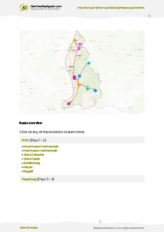
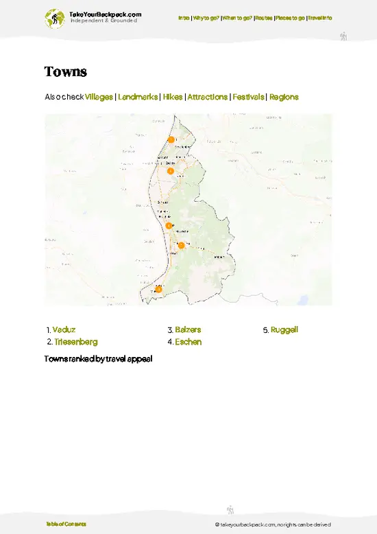
example page 0 from our offline Travel Guide for Liechtenstein
example page 1 from our offline Travel Guide for Liechtenstein
example page 2 from our offline Travel Guide for Liechtenstein
example page 3 from our offline Travel Guide for Liechtenstein
example page 4 from our offline Travel Guide for Liechtenstein
example page 5 from our offline Travel Guide for Liechtenstein
example page 6 from our offline Travel Guide for Liechtenstein
example page 7 from our offline Travel Guide for Liechtenstein
The digital guide (106 pages) contains:-page digital guide:
✅ Ready-made 2, 3 & 5-day routes
✅ All 25 places ranked, so you skip the overrated ones
✅ Works offline, all in 1 guide
✅ Cities, national parks, landmarks, beaches
✅ How to get around
👉 Click to see all 30+ guide features

📅 Plan smarter in minutes, not weeks
✅ Month by month travel advice
✅ Festivals & national holidays
✅ Budget expectations

🗺️ Go to the right places, skip the overrated ones
✅ Honest pros & cons of destinations
✅ Top hikes, parks & viewpoints
✅ Lesser-known places most travelers miss
✅ Clear “worth it vs skip it” guidance

🛏️ Travel smoothly without rookie mistakes
✅ Best areas to stay
✅ Transport systems explained simply
✅ Common scams & safety advice
✅ SIM cards, money & practical tips

🌍 Understand the country, not just visit it
✅ Culture & traditions
✅ 52 Essential phrases & customs
✅ Festivals worth planning around
✅ Traveler-friendly historical context
✅ Insights that make places more meaningful

📱 Built for real travel conditions
✅ Fully downloadable PDF
✅ Works completely offline
✅ Optimized for phone use
✅ Useful in remote areas & buses
✅ All in 1 guide
Stop searching, start planning
Get instant access to your full guide. 30‑day money-back guarantee.


By proceeding you agree to our terms.
Sent to your inbox immediately after payment • 100% Secure Checkout
Best Backpacking Travel Advisor 2025 tourism awardBest Backpacking
Travel Advisor
2025
What others say about Take Your Backpack Guides:
⭐⭐⭐⭐⭐
Fantastic, amazing amount of information!
⭐⭐⭐⭐⭐
My goodness this is amazing, it's what I've been looking for hats off too you!
⭐⭐⭐⭐⭐
I think this is absolutely BRILLIANT
⭐⭐⭐⭐
Very complete and informative. It's still missing places, but I gotta to commend you
⭐⭐⭐⭐⭐
This is truly amazing, thank you, can't wait to explore it with my kids!
⭐⭐⭐⭐⭐
Awesome resource, thank you!
⭐⭐⭐⭐⭐
This is amazing! Can't wait to explore the ones I haven't seen
⭐⭐⭐⭐
I love this! Well done, great idea.
⭐⭐⭐⭐⭐
Thanks for taking the time to make this gem!
⭐⭐⭐⭐⭐
This might be the best website I've ever seen.
⭐⭐⭐⭐⭐
Congratulations, and thank you so much for your work; it's incredibly valuable.
⭐⭐⭐⭐
In all seriousness I think you did a great job pointing out the important spots
⭐⭐⭐⭐⭐
10/10 very good
⭐⭐⭐⭐⭐
As someone who's only just starting to visit regularly this is awesome, thank you.
⭐⭐⭐⭐
Thank you very much! I'm going to visit my dad, it's going to be very useful!
⭐⭐⭐⭐⭐
This is really cool! We'll be travelling for the first time and this definitely come in handy.
⭐⭐⭐⭐⭐
You are now our minister of culture, congratulations 👨‍💼
⭐⭐⭐⭐⭐
Just wanted to tell you that this is a pearl! Going to follow your recommendations.
⭐⭐⭐⭐⭐
This is so cool. I'll definitely be using the resource for my travels soon.
⭐⭐⭐⭐⭐
This is very impressive! Good work.
⭐⭐⭐⭐⭐
This is an amazing and informative site. Very well done!

🛏️ Where to stay?Choosing the right base

If you enjoy meeting fellow travelers, consider choosing hostels with high ratings for atmosphere. On the other hand, if you prefer having your own space, a hotel might be a better option.

🥾 Hike detailsEverything you need to know before hiking Malbun to Sareis

Total Distance: Malbun to Sareis is a short walk of roughly 4 kilometers one way, depending on whether you follow the direct track or a longer ridge variation.
Estimated Duration: Plan on 1.5 to 2 hours up and about an hour down, plus time for the views and a meal at the restaurant.
Difficulty: Easy to moderate. The trail is wide and well marked, with a steady climb and no exposed sections on the main route.
Starting Point: The bus stop in Malbun, reached by LIEmobil bus from Vaduz via Triesenberg. The trailhead is a few minutes on foot from the lift stations and the main road.
Major Landmarks:
  • Malbun
… read more 👉
Total Distance: Malbun to Sareis is a short walk of roughly 4 kilometers one way, depending on whether you follow the direct track or a longer ridge variation.
Estimated Duration: Plan on 1.5 to 2 hours up and about an hour down, plus time for the views and a meal at the restaurant.
Difficulty: Easy to moderate. The trail is wide and well marked, with a steady climb and no exposed sections on the main route.
Starting Point: The bus stop in Malbun, reached by LIEmobil bus from Vaduz via Triesenberg. The trailhead is a few minutes on foot from the lift stations and the main road.
Major Landmarks:
  • Malbun village: The start, with cafés, guesthouses and the chairlift base.
  • Sareis: The pasture area with its mountain restaurant, the usual turnaround point.
  • Sareiserjoch: The ridge saddle just above, with views across the Rätikon.
Terrain and Scenery: A broad gravel and grass track climbs through open slopes, with a few steeper stretches near the top. Expect wide views over the Valüna valley and rocky peaks lining the horizon.
Vegetation: Alpine meadow dominates, with spruce and mountain pine near the village. Wildflowers bloom in early summer, and the pastures turn golden in autumn.
Wildlife: Alpine marmots whistle from burrows, chamois are seen on the steeper slopes, and cattle graze the pastures in summer. Birds of prey circle the ridges.
Practical Notes: Bring layers, because the weather changes quickly at this altitude. Water and food are available at the restaurant when it is open, and the chairlift can save your knees on the way down in season.
⚠️ Hiking info can sometimes be outdated or inaccurate. Before you hit the trail, check the latest conditions with locals. If you do spot anything that's off, I'd love to hear from you, so I can update it for fellow travelers.

🛡️ SafetyTraveler Safety Guide

The route from Malbun up to Sareis is a well-marked mountain path, and most problems come from weather and footwear rather than terrain. The climb is steady, roughly 300 to 400 meters, over grassy slopes and some rocky sections that turn slick after rain. Wear boots with real tread, not trail shoes with worn soles. Summer storms build quickly above 1,600 meters, with lightning on exposed ridges, so check the forecast and turn back when clouds darken. Even in July the wind can feel cold, so pack a shell and a warm layer. Early snow can linger on shaded patches into early summer. Cattle often graze near the trail, so keep dogs leashed, walk calmly around them and close pasture gates behind you. Carry water, because refills are limited once you leave Malbun. Mobile coverage is generally good, and the emergency number is 112.

FAQCommon questions from travelers

Malbun to Sareis takes about 1 to 1.5 hours uphill and 45 to 60 minutes back down. Most hikers start from the bus stop in Malbun at roughly 1,600 meters. Adding the ridge toward Augstenberg turns it into a half-day outing of 3 to 5 hours, and the chairlift can replace either direction.
Malbun to Sareis is an easy to moderate hike, with a steady climb of about 300 to 400 meters on marked paths. Fit beginners manage it at a relaxed pace, though stony stretches get slippery when wet. Longer extensions to higher ridges are more demanding, so allow extra energy and daylight if you continue.
Neither a guide nor a permit is required for Malbun to Sareis, since the paths are public and signposted in yellow. You only pay if you ride the Sareis chairlift, which costs roughly €8 to 14 depending on direction and season. The bus from Vaduz to Malbun takes about 30 to 40 minutes.
⚠️ Things can change over time, so always validate details locally before you go.

Other Liechtensteiner hikes near Malbun to Sareis

Explore more nearby:

  • Gänglesee Trail—Mountain pond loop, cowbell pastures, larch and spruce, quiet Triesenberg uplands| 2 km away
  • Rappenstein—2,222 m summit, narrow ridge, Valüna descent, 17 km loop| 2 km away
  • Fürstensteig—Cabled limestone ledge, Gaflei trailhead, Drei Schwestern views, sheer drops| 7 km away

💡 Not sure where to go next?
Create a personalized itinerary for Liechtenstein including Malbun to Sareis and the places that fit your trip.

Generate my itinerary

👉 Discover all hikes

Or checkout all Liechtenstein has to offer (think cities, towns, villages, national parks, hikes, beaches, festivals)
Country photo of Liechtenstein

We 💚 feedbackKey takeaways before you go

Malbun to Sareis suits easy-going hikers, families and anyone who wants a big alpine view without a big day. I would go on a clear weekday morning, bring a windproof layer even in July, and pack lunch, because the cafés fill fast on sunny weekends. Skip it in poor visibility; the views are the whole point.

✍️ Help improve this page!
The information on this page is based on in-depth research, insights shared by experienced travelers, and feedback from the local travel community in Liechtenstein. While every effort is made to keep the information accurate and current, conditions can change — so if you spot anything incorrect or outdated, please get in touch.


🙋‍♂️ Give feedback

👋 Meet the founderWho’s Behind Take Your Backpack?

Johan, backpacker and founder of TakeYourBackpackHi, I’m Johan (Netherlands 🇳🇱), the creator of TakeYourBackpack. Over the past 30 years, I’ve backpacked through 88 countries across six continents, gaining extensive experience with independent travel, long-term trips, and overland routes.

This site is built on a combination of firsthand travel experience and carefully curated insights from other backpackers. Many guides are based on places I’ve personally visited, while others bring together tips, observations, and practical advice shared by trusted travelers I’ve met along the way.

The goal is to provide realistic, experience-driven guidance — not generic itineraries — so you can explore destinations with better context, clearer expectations, and more confidence.