×

Mauritania🇲🇷 | hikesGuelb er Richat Trailgeological dome, concentric rock rings, desert plateau | things to do and best time to go

Explore Amogjar PassExplore Banc d’Arguin National Park

Backpacking in Guelb er Richat Trail
🌟 Highlighthike ranked #2
By Johan Kruseman 🇳🇱 | Updated May 25, 2026

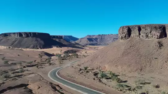
Sand grinds between your teeth as the wind slaps your face, and the sun—unfiltered, merciless—turns your sweat to salt before it can drip. You crest a dune, calves burning, and suddenly the Eye of the Sahara yawns below: a colossal swirl of rock and sand, so alien it feels like you’ve stumbled onto another planet. This is the Guelb er Richat Trail, deep in Mauritania’s Adrar region, a two-day trek that’s as much a test of stubbornness as stamina. The scenery is raw—think endless ochre plains, fossil-studded ridges, and that hypnotic, spiraling crater. It’s not an easy walk: the heat is punishing, shade is a rumor, and the trailhead is a logistical headache unless you’ve arranged a 4x4 from Atar (public transport is a mirage out here). But compared to the more accessible Amogjar Pass or Terjit Oasis hikes, Guelb er Richat delivers a sense of scale and isolation that’s rare even by Mauritanian standards. The payoff? That first gulp of tepid well water, the silence so complete your heartbeat feels like thunder, and the knowledge you’ve walked somewhere most maps barely bother to name.

Discover everything you want to know in the 📖 Mauritania Travel Guide.
Best time to go: October - April
Duration: 3 days
Distance: 20 kilometers
Total ascent: 400 meters
Safety warning

The current risk level for Mauritania is high. Check the advice before going.


Get your Mauritania guide
63 ranked highlights, routes & tips, works offline (269 pages)
Loading the map 🌍
CLICK TO FILTER
cities
towns
villages
landmarks
national parks
hikes
beaches
attractions
festivals
regions
SHOW COUNTRY’S BESTSHOW ALL

✨ Why go?
Ranked #2 hike in Mauritania
The unique appeal for travelers

The Guelb er Richat Trail in Mauritania is a magnet for backpackers craving adventure. This hike offers a scenery-to-effort ratio that’s hard to beat. You’ll traverse a surreal landscape of ochre and blue, where the ancient eye of the Sahara stares back at you. The burn of the trails is real, but every step brings you closer to that breathtaking view of the Richat Structure, a geological marvel that feels like stepping onto another planet.

Accessing the trail is a breeze. Public transport options are available from nearby towns, making it easy to get there without breaking the bank. The low cost of the hike means you can splurge on a cold beer afterward without guilt.

What’s more, the trail offers flexible distances. Whether you want a quick day hike or a more extended trek, you can tailor … read more 👉
The Guelb er Richat Trail in Mauritania is a magnet for backpackers craving adventure. This hike offers a scenery-to-effort ratio that’s hard to beat. You’ll traverse a surreal landscape of ochre and blue, where the ancient eye of the Sahara stares back at you. The burn of the trails is real, but every step brings you closer to that breathtaking view of the Richat Structure, a geological marvel that feels like stepping onto another planet.

Accessing the trail is a breeze. Public transport options are available from nearby towns, making it easy to get there without breaking the bank. The low cost of the hike means you can splurge on a cold beer afterward without guilt.

What’s more, the trail offers flexible distances. Whether you want a quick day hike or a more extended trek, you can tailor your experience. This adaptability makes it a perfect fit in a longer backpacking route through Mauritania, allowing you to dive deeper into the country’s rugged beauty.

The moment you reach the summit, the effort pays off. That view? It’s a reward that lingers long after you’ve left the trail.
Want to include Guelb er Richat Trail in your Mauritania route?
Create a personalized Mauritania itinerary that includes Guelb er Richat Trail and the places that fit your trip — based on your travel style, budget, and available time. Get your route in seconds.

Generate my trip

💡 HighlightsEssential experiences to have while hiking the Guelb er Richat Trail

  1. Eye of the Sahara (central uplift viewpoint) — The reason you came: a huge bull’s-eye of concentric rings cut into the desert that looks unreal from the rim. Walk to a high point at dawn or dusk and the scale — kilometers of layered bands and the flat desert beyond — really hits you. It’s the single-most iconic view any other trail can’t copy.
  2. Concentric rock bands and strange folds — Up close the rings aren’t just pretty; they’re different rock types eroded into sharp ridges and scarps. Colors, striations and sudden steps in the rock make for excellent scrambling and photos, and the geology is obvious even to non-geologists.
  3. Fossil beds and ancient seabed clues — Parts of the Richat expose sedimentary layers full of marine fossils and shells — a quiet reminder this place was underwater
read more 👉
  1. Eye of the Sahara (central uplift viewpoint) — The reason you came: a huge bull’s-eye of concentric rings cut into the desert that looks unreal from the rim. Walk to a high point at dawn or dusk and the scale — kilometers of layered bands and the flat desert beyond — really hits you. It’s the single-most iconic view any other trail can’t copy.
  2. Concentric rock bands and strange folds — Up close the rings aren’t just pretty; they’re different rock types eroded into sharp ridges and scarps. Colors, striations and sudden steps in the rock make for excellent scrambling and photos, and the geology is obvious even to non-geologists.
  3. Fossil beds and ancient seabed clues — Parts of the Richat expose sedimentary layers full of marine fossils and shells — a quiet reminder this place was underwater millions of years ago. It’s a tiny time capsule in stone; bring a loupe if you like, but don’t pry things loose.
  4. Saharan solitude, dunes and star nights — The surrounding desert is stark and huge: sand seas, wind-sculpted ridges, endless horizon. Hike out for a sunset over the dunes and you’ll get light and textures most trails don’t offer. At night the Milky Way is ridiculously clear — proper desert camping territory.
  5. Local desert life and brief cultural contact — Scattered camps and nomadic herders (Mauritanian Moors and other desert dwellers) still move through the area. If you go with a local guide you can meet them, share mint tea, and hear how they read the landscape — a cultural layer that turns the hike from scenery into a place with human stories.
Spotted a mistake or missing something? Contact us.

Things to do near Guelb er Richat Trail

Ratings based on Tripadvisor reviews. When you book through this link, you support our work at no extra cost to you.

🌤️ When to go?When to go for the best experience


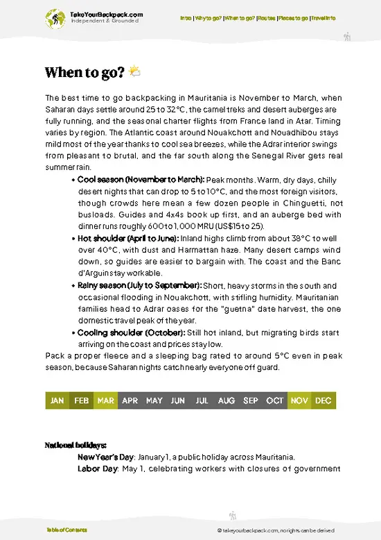
  • Weather: The best window is between October and April when the Sahara’s brutal heat eases. Daytime highs hover around 25-30°C (77-86°F), making the trail manageable without frying your skin or lungs.

  • Temperature: Nights can dip sharply, especially in winter, dropping to 5°C (41°F) or lower. Layering is non-negotiable—prepare for a chilly desert night after a warm day on the trail.

  • Daylight Hours: Expect roughly 10-12 hours of daylight during the prime hiking months, enough to push hard on the trail but not so long that you lose track of time or burn out.

  • Crowds: The trail is remote enough to avoid mass tourism year-round, but the cooler months see a slight uptick in international trekkers. You’ll still have plenty of solitude.

  • Seasonal Activities: Cooler months align with local
read more 👉

  • Weather: The best window is between October and April when the Sahara’s brutal heat eases. Daytime highs hover around 25-30°C (77-86°F), making the trail manageable without frying your skin or lungs.

  • Temperature: Nights can dip sharply, especially in winter, dropping to 5°C (41°F) or lower. Layering is non-negotiable—prepare for a chilly desert night after a warm day on the trail.

  • Daylight Hours: Expect roughly 10-12 hours of daylight during the prime hiking months, enough to push hard on the trail but not so long that you lose track of time or burn out.

  • Crowds: The trail is remote enough to avoid mass tourism year-round, but the cooler months see a slight uptick in international trekkers. You’ll still have plenty of solitude.

  • Seasonal Activities: Cooler months align with local nomadic festivals and markets, adding cultural spice to your trek without disrupting your route.

  • Price Fluctuations: Off-peak summer months bring lower prices but also punishing heat that can kill your vibe. Peak season rates climb modestly but reward you with safer, more comfortable conditions.


Pro-tip: Aim for late October or early April to catch the sweet spot—cool enough to move fast, warm enough to enjoy evenings without freezing.


source: climatestotravel.comJANJanuary: excellent for travelingFEBFebruary: excellent for travelingMARMarch: excellent for travelingAPRApril: highly recommended for travelingMAYMay: fair for travelingJUNJune: below average for travelingJULJuly: below average for travelingAUGAugust: below average for travelingSEPSeptember: fair for travelingOCTOctober: highly recommended for travelingNOVNovember: excellent for travelingDECDecember: excellent for traveling
when-to-go

✈️ The backpacker research shortcutMauritania Travel Guide

An offline-friendly backpacking guide with optimized travel routes, ranked highlights, transport advice, and the best areas to stay.
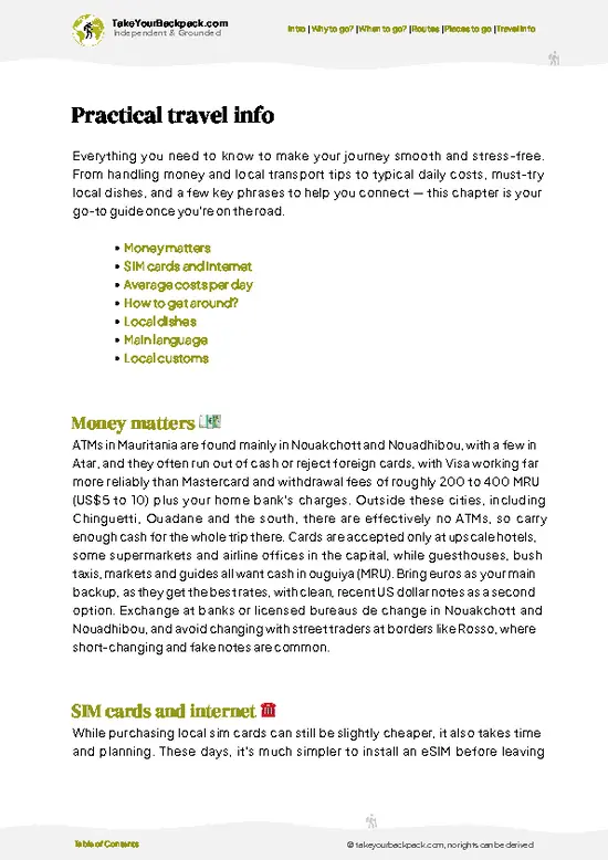
example page 0 from our offline Travel Guide for Mauritania
example page 1 from our offline Travel Guide for Mauritania
example page 2 from our offline Travel Guide for Mauritania
example page 3 from our offline Travel Guide for Mauritania
example page 4 from our offline Travel Guide for Mauritania
example page 5 from our offline Travel Guide for Mauritania
example page 6 from our offline Travel Guide for Mauritania
example page 7 from our offline Travel Guide for Mauritania
The digital guide (269 pages) contains:
63 highlights, ranked by travel appeal
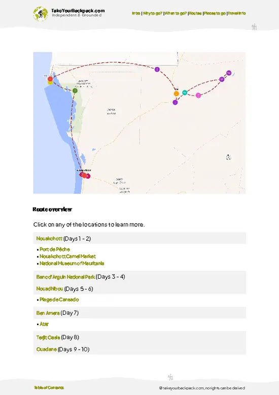
Optimized 5, 10 & 15-day travel routes
Cities, national parks, landmarks, beaches
How to get around
Offline-friendly for travel without Wi-Fi
👉 Click to see all 30+ guide features

📅 Plan smarter in minutes, not weeks
Month by month travel advice
Festivals & national holidays
Budget expectations

🗺️ Go to the right places, skip the overrated ones
Honest pros & cons of destinations
Top hikes, parks & viewpoints
Lesser-known places most travelers miss
Clear “worth it vs skip it” guidance

🛏️ Travel smoothly without rookie mistakes
Best areas to stay
Transport systems explained simply
Common scams & safety advice
SIM cards, money & practical tips

🌍 Understand the country, not just visit it
Culture & traditions
52 Essential phrases & customs
Festivals worth planning around
Traveler-friendly historical context
Insights that make places more meaningful

📱 Built for real travel conditions
Fully downloadable PDF
Works completely offline
Optimized for phone use
Useful in remote areas & buses
Everything in one place
Save weeks of stressful planning
Get instant access to your full guide. 30‑day money-back guarantee.


By proceeding you agree to our terms.
Sent to your inbox immediately after payment • 100% Secure Checkout
Best Backpacking Travel Advisor 2025 tourism awardBest Backpacking
Travel Advisor
2025
What others say about Take Your Backpack Guides:
⭐⭐⭐⭐⭐
Fantastic, amazing amount of information!
⭐⭐⭐⭐⭐
My goodness this is amazing, it's what I've been looking for hats off too you!
⭐⭐⭐⭐⭐
I think this is absolutely BRILLIANT
⭐⭐⭐⭐
Very complete and informative. It's still missing places, but I gotta to commend you
⭐⭐⭐⭐⭐
This is truly amazing, thank you, can't wait to explore it with my kids!
⭐⭐⭐⭐⭐
Awesome resource, thank you!
⭐⭐⭐⭐⭐
This is amazing! Can't wait to explore the ones I haven't seen
⭐⭐⭐⭐
I love this! Well done, great idea.
⭐⭐⭐⭐⭐
Thanks for taking the time to make this gem!
⭐⭐⭐⭐⭐
This might be the best website I've ever seen.
⭐⭐⭐⭐⭐
Congratulations, and thank you so much for your work; it's incredibly valuable.
⭐⭐⭐⭐
In all seriousness I think you did a great job pointing out the important spots
⭐⭐⭐⭐⭐
10/10 very good
⭐⭐⭐⭐⭐
As someone who's only just starting to visit regularly this is awesome, thank you.
⭐⭐⭐⭐
Thank you very much! I'm going to visit my dad, it's going to be very useful!
⭐⭐⭐⭐⭐
This is really cool! We'll be travelling for the first time and this definitely come in handy.
⭐⭐⭐⭐⭐
You are now our minister of culture, congratulations 👨‍💼
⭐⭐⭐⭐⭐
Just wanted to tell you that this is a pearl! Going to follow your recommendations.
⭐⭐⭐⭐⭐
This is so cool. I'll definitely be using the resource for my travels soon.
⭐⭐⭐⭐⭐
This is very impressive! Good work.
⭐⭐⭐⭐⭐
This is an amazing and informative site. Very well done!

🛏️ Where to stay?Choosing the right base

If you enjoy meeting fellow travelers, consider choosing hostels with high ratings for atmosphere. On the other hand, if you prefer having your own space, a hotel might be a better option.

🥾 Hike detailsRoute, distance, and difficulty explained

Total Distance: Approximately 15 kilometers round trip. This trail loops around the stunning Richat Structure, also known as the Eye of Africa.

Estimated Duration: Expect to spend around 5 to 7 hours on the trail, depending on your pace and how often you stop to take in the views or snap photos.

Difficulty Level: Moderate. While the terrain isn’t overly technical, the heat and distance can make it challenging, especially for those not acclimated to the desert environment.

Starting Point: The trail typically starts near the town of Ouadane.
  • Getting There by Public Transport: From Nouakchott,
read more 👉
Total Distance: Approximately 15 kilometers round trip. This trail loops around the stunning Richat Structure, also known as the Eye of Africa.

Estimated Duration: Expect to spend around 5 to 7 hours on the trail, depending on your pace and how often you stop to take in the views or snap photos.

Difficulty Level: Moderate. While the terrain isn’t overly technical, the heat and distance can make it challenging, especially for those not acclimated to the desert environment.

Starting Point: The trail typically starts near the town of Ouadane.
  • Getting There by Public Transport: From Nouakchott, take a shared taxi or bus to Atar. This ride takes about 12 hours, so buckle in. From Atar, you can catch a local taxi to Ouadane, which is around a 1.5-hour drive. Make sure to ask around for the best drop-off point near the trailhead.

Major Landmarks Along the Route:
  • Richat Structure: The main attraction, this geological formation is a mesmerizing circular feature visible from space, and it’s a great spot for photos.
  • Local Rock Formations: As you hike, you’ll encounter unique rock formations that add to the dramatic scenery.
  • Ancient Ruins: Keep an eye out for remnants of old structures—these hints of history can make for interesting detours.

Type of Terrain and Scenery: The trail features a mix of sandy paths, rocky outcrops, and some gentle inclines. The scenery is a blend of vast desert landscapes, striking rock formations, and the occasional oasis. The colors change throughout the day, especially during sunrise and sunset, creating a stunning backdrop.

Typical Vegetation and Wildlife:
  • Vegetation: Expect to see sparse desert flora, including acacia trees and hardy shrubs. These plants are adapted to the arid conditions.
  • Wildlife: You might spot some desert lizards, small rodents, and a variety of birds. Keep your eyes peeled for the occasional gazelle in the distance.

This trail offers a great mix of adventure and natural beauty, perfect for those looking to explore Mauritania’s unique landscapes. Just remember to bring plenty of water, sunscreen, and a good sense of direction!
⚠️ Hiking info can sometimes be outdated or inaccurate. Before you hit the trail, check the latest conditions with locals. If you do spot anything that's off, I'd love to hear from you, so I can update it for fellow travelers.

🛡️ SafetySafety Tips and Common Scams in Guelb er Richat Trail

The Guelb er Richat Trail in Mauritania offers a unique blend of challenge and reward. Expect the sun to beat down fiercely, especially in the summer months. Hydration is key; carry enough water and take breaks in the shade. The terrain can shift from rocky outcrops to sandy stretches, so sturdy footwear is essential. Navigation is straightforward, but keep an eye on your surroundings—landmarks can shift in the heat haze.

Wildlife encounters are rare, but if you spot a desert fox or a wandering gazelle, enjoy the moment without approaching. Respect their space; you’re a guest in their home.

Timing your hike is crucial. Early mornings or late afternoons offer cooler temperatures and stunning light for photos. Keep your pace steady; this isn’t a sprint. Embrace the rhythm of the trail, and … read more 👉
The Guelb er Richat Trail in Mauritania offers a unique blend of challenge and reward. Expect the sun to beat down fiercely, especially in the summer months. Hydration is key; carry enough water and take breaks in the shade. The terrain can shift from rocky outcrops to sandy stretches, so sturdy footwear is essential. Navigation is straightforward, but keep an eye on your surroundings—landmarks can shift in the heat haze.

Wildlife encounters are rare, but if you spot a desert fox or a wandering gazelle, enjoy the moment without approaching. Respect their space; you’re a guest in their home.

Timing your hike is crucial. Early mornings or late afternoons offer cooler temperatures and stunning light for photos. Keep your pace steady; this isn’t a sprint. Embrace the rhythm of the trail, and when you finally reach that panoramic view, the effort will feel like a well-earned victory. A cold drink at the end? That’s just the cherry on top.

Other Mauritanian hikes near Guelb er Richat Trail

Explore more nearby:

  • Ouadane to Chinguetti Trek—ancient caravan route, stone ksour, sand dunes| 168 km away
  • Amogjar Pass—sandstone cliffs, prehistoric rock art, narrow canyons| 180 km away
  • Ben Amera—granite monolith, desert sculptures, open plains| 235 km away

💡 Not sure where to go next?
Create a personalized itinerary for Mauritania including Guelb er Richat Trail and the places that fit your trip.

Generate my itinerary

👉 Discover all hikes

Or checkout all Mauritania has to offer (think cities, towns, villages, national parks, hikes, beaches, festivals)
Country photo of Mauritania

We 💚 feedbackFinal thoughts on hiking the Guelb er Richat Trail

The Guelb er Richat Trail isn’t just a hike; it’s a full-body experience. You’ll feel the grit of the sand underfoot and the sun beating down, but then—bam!—you hit that ridge and the view opens up like a cosmic eye. The best surprise? The silence. It’s profound. Just you and the vastness. But a heads-up: the heat can be relentless. Hydrate like it’s your job. Embrace the challenge; the reward is worth every step.

✍️ Help improve this page!
The information on this page is based on in-depth research, insights shared by experienced travelers, and feedback from the local travel community in Mauritania. While every effort is made to keep the information accurate and current, conditions can change — so if you spot anything incorrect or outdated, please get in touch.


🙋‍♂️ Give feedback

👋 Meet the founderWho’s Behind Take Your Backpack?

Johan, backpacker and founder of TakeYourBackpackHi, I’m Johan (Netherlands 🇳🇱), the creator of TakeYourBackpack. Over the past decade, I’ve backpacked through 80+ countries across six continents, gaining extensive experience with independent travel, long-term trips, and overland routes.

This site is built on a combination of firsthand travel experience and carefully curated insights from other backpackers. Many guides are based on places I’ve personally visited, while others bring together tips, observations, and practical advice shared by trusted travelers I’ve met along the way.

The goal is to provide realistic, experience-driven guidance — not generic itineraries — so you can explore destinations with better context, clearer expectations, and more confidence.

Get full Mauritania guide •
Instant download • 63 highlights • Full Offline guide