×

North Korea🇰🇵 | hikesMyohyangsantemple complexes, deep valleys, misty forests | things to do and best time to go

Explore Suyangsan TrailExplore Kumgangsan

Backpacking in Myohyangsan
🏆 Top pickhike ranked #2
By Johan Kruseman 🇳🇱 | Updated June 10, 2026

Most people online sell Myohyangsan as a pure “revolutionary shrine,” but the surprise for backpackers is that once you step away from the propaganda halls, it’s a legitimately rugged mountain playground with real, leg-burning trails. Myohyangsan sits in North Pyongan Province, in the northwest of North Korea, and the main hiking routes climb straight out of the resort area near Hyangsan. The core hike is medium-length but punchy: steep stone steps, exposed ridges, and slick rock after rain, with sharp granite peaks and deep, forested valleys that feel more Korean Alps than theme park. Access is both easy and frustrating: it’s simple because your tour bus drops you right at the trailhead, impossible because you can’t just hop on public transport and go solo. Compared to the softer coastal walks near Wonsan or the more famous Paektu area, Myohyangsan feels more compact, steeper, and more controlled—but also more immediately rewarding once you hit the ridgeline and the whole valley opens up beneath you.

Discover everything you want to know in the 📖 North Korea Travel Guide.
Best time to go: April - June, September - November
Duration: 2 days
Distance: 20 kilometers
Total ascent: 1,600 meters
Safety warning

The current risk level for North Korea is high. Check the advice before going.


Get your North Korea guide
74 ranked highlights, routes & tips, works offline (296 pages)
Loading the map 🌍
CLICK TO FILTER
cities
towns
landmarks
national parks
hikes
beaches
attractions
festivals
regions
SHOW COUNTRY’S BESTSHOW ALL

✨ Why go?
Ranked #2 hike in North Korea
What makes this hike worth hiking

Backpackers flock to Myohyangsan for a taste of North Korea’s rugged beauty, where the scenery-to-effort ratio is nothing short of spectacular. You’ll find yourself surrounded by jagged peaks and lush valleys, all while feeling the burn in your legs. The trails here are well-marked, offering options for both the casual wanderer and the seasoned trekker.

Getting there is a breeze with public transport access from Pyongyang. Hop on a bus, and in no time, you’re immersed in nature, leaving the city’s starkness behind. The low cost of entry makes it even more appealing; a small fee grants you access to this breathtaking landscape.

What’s more, the flexible distances allow you to tailor your hike to your energy levels. Whether you tackle a short jaunt or a full-day trek, the payoff is always … read more 👉
Backpackers flock to Myohyangsan for a taste of North Korea’s rugged beauty, where the scenery-to-effort ratio is nothing short of spectacular. You’ll find yourself surrounded by jagged peaks and lush valleys, all while feeling the burn in your legs. The trails here are well-marked, offering options for both the casual wanderer and the seasoned trekker.

Getting there is a breeze with public transport access from Pyongyang. Hop on a bus, and in no time, you’re immersed in nature, leaving the city’s starkness behind. The low cost of entry makes it even more appealing; a small fee grants you access to this breathtaking landscape.

What’s more, the flexible distances allow you to tailor your hike to your energy levels. Whether you tackle a short jaunt or a full-day trek, the payoff is always worth it. Picture this: you reach a summit, the wind whipping through your hair, and the view unfurls like a green carpet below.

This hike fits seamlessly into a longer backpacking route, making it a perfect pit stop. You’ll leave with a sense of accomplishment and maybe even a cold beer in hand, savoring the moment.
Want to include Myohyangsan in your North Korea route?
Create a personalized North Korea itinerary that includes Myohyangsan and the places that fit your trip — based on your travel style, budget, and available time. Get your route in seconds.

Generate my trip

💡 HighlightsThe experiences that define the visit

  1. Pohyon Temple — An atmospheric, centuries-old Buddhist complex tucked into the mountain slope; wooden halls, carved eaves and quiet courtyards make for one of the most peaceful temple visits you’ll get while actually hiking. It’s special because the buildings feel like part of the rock itself — shade, incense and monk-led rhythms break up the climb in a way you don’t get on purely natural trails. (Personal favorite: sit on a temple step and watch the clouds roll through the peaks.)
  2. Summit ridge / main viewpoints — The final ridgeline delivers those wide, “I climbed something” panoramas: jagged granite teeth, deep valleys and the patchwork of lowland farms far below. Morning mist and rapid weather changes make the light dramatic, so the views here feel more cinematic than on many other East
read more 👉
  1. Pohyon Temple — An atmospheric, centuries-old Buddhist complex tucked into the mountain slope; wooden halls, carved eaves and quiet courtyards make for one of the most peaceful temple visits you’ll get while actually hiking. It’s special because the buildings feel like part of the rock itself — shade, incense and monk-led rhythms break up the climb in a way you don’t get on purely natural trails. (Personal favorite: sit on a temple step and watch the clouds roll through the peaks.)
  2. Summit ridge / main viewpoints — The final ridgeline delivers those wide, “I climbed something” panoramas: jagged granite teeth, deep valleys and the patchwork of lowland farms far below. Morning mist and rapid weather changes make the light dramatic, so the views here feel more cinematic than on many other East Asian hikes.
  3. Granite spires and cliffs — Myohyangsan is full of steep, sculpted granite towers and narrow gullies; the trail often skims cliff edges and offers up close-up geology that’s more vertical than forested. Those raw, sculpted rocks give the mountain a very rugged character compared with gentler, tree-covered ranges.
  4. Streams, cascades and clear pools — Small waterfalls and rock-lined streams thread the valley floors and lower slopes, perfect for cooling off or pausing with a snack. The water is unusually clear and the sound of the cascades cuts through the silence of the pines — a nice contrast to the exposed ridges above.
  5. International Friendship Exhibition — Not a natural highlight, but an unforgettable cultural detour at the base of the mountain: vast exhibition halls housing gifts presented to the nation’s leaders. It’s a unique, slightly surreal museum experience that you won’t find on other hiking itineraries and makes for a memorable bookend to the wilderness part of the trip.
Spotted a mistake or missing something? Contact us.
🌤️ When to go?When to go for the best experience


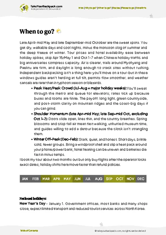
  • Weather: Spring (April to June) and autumn (September to October) deliver the clearest skies and crisp air, perfect for tackling Myohyangsan’s rugged trails. Summers can scorch with humidity pushing 30°C (86°F), while winters plunge below freezing, often locking the paths in ice.

  • Temperature: Expect mild days around 15-22°C (59-72°F) in spring and fall, ideal for sustained hiking without overheating or frostbite risk. Nights dip to 5-10°C (41-50°F), so pack layers.

  • Daylight Hours: Spring and autumn offer a sweet spot of 11-13 hours of daylight, enough to push deep into the mountain’s folds without rushing or risking a nightfall scramble.

  • Crowds: The mountain sees a surge during national holidays and weekends, especially in autumn when locals chase fall foliage. Weekdays in shoulder seasons
read more 👉

  • Weather: Spring (April to June) and autumn (September to October) deliver the clearest skies and crisp air, perfect for tackling Myohyangsan’s rugged trails. Summers can scorch with humidity pushing 30°C (86°F), while winters plunge below freezing, often locking the paths in ice.

  • Temperature: Expect mild days around 15-22°C (59-72°F) in spring and fall, ideal for sustained hiking without overheating or frostbite risk. Nights dip to 5-10°C (41-50°F), so pack layers.

  • Daylight Hours: Spring and autumn offer a sweet spot of 11-13 hours of daylight, enough to push deep into the mountain’s folds without rushing or risking a nightfall scramble.

  • Crowds: The mountain sees a surge during national holidays and weekends, especially in autumn when locals chase fall foliage. Weekdays in shoulder seasons keep the trails quieter, letting you own the experience.

  • Seasonal Activities: Autumn brings vibrant foliage festivals and temple ceremonies that add cultural punch to your trek. Spring’s wildflowers and fresh greenery offer a softer, rejuvenating vibe.

  • Price Fluctuations: Tours and permits spike in peak seasons—spring and autumn—due to demand. Off-season travel can save you some won but expect harsher conditions.


Pro-tip: Aim for late September weekdays—cool temps, long light, and fewer crowds—so you can chase the mountain’s raw edges and still catch the fiery fall colors without the crush.


source: climatestotravel.comJANJanuary: below average for travelingFEBFebruary: below average for travelingMARMarch: fair for travelingAPRApril: excellent for travelingMAYMay: excellent for travelingJUNJune: highly recommended for travelingJULJuly: fair for travelingAUGAugust: fair for travelingSEPSeptember: excellent for travelingOCTOctober: excellent for travelingNOVNovember: good for travelingDECDecember: below average for traveling
when-to-go

✈️ The backpacker research shortcutNorth Korea Travel Guide

An offline-friendly backpacking guide with optimized travel routes, ranked highlights, transport advice, and the best areas to stay.
example page 0 from our offline Travel Guide for North Korea
example page 1 from our offline Travel Guide for North Korea
example page 2 from our offline Travel Guide for North Korea
example page 3 from our offline Travel Guide for North Korea
example page 4 from our offline Travel Guide for North Korea
example page 5 from our offline Travel Guide for North Korea
example page 6 from our offline Travel Guide for North Korea
example page 7 from our offline Travel Guide for North Korea
The digital guide (296 pages) contains:
74 highlights, ranked by travel appeal
Optimized 5, 10 & 15-day travel routes
Cities, national parks, landmarks, beaches
How to get around
Offline-friendly for travel without Wi-Fi
👉 Click to see all 30+ guide features

📅 Plan smarter in minutes, not weeks
Month by month travel advice
Festivals & national holidays
Budget expectations

🗺️ Go to the right places, skip the overrated ones
Honest pros & cons of destinations
Top hikes, parks & viewpoints
Lesser-known places most travelers miss
Clear “worth it vs skip it” guidance

🛏️ Travel smoothly without rookie mistakes
Best areas to stay
Transport systems explained simply
Common scams & safety advice
SIM cards, money & practical tips

🌍 Understand the country, not just visit it
Culture & traditions
52 Essential phrases & customs
Festivals worth planning around
Traveler-friendly historical context
Insights that make places more meaningful

📱 Built for real travel conditions
Fully downloadable PDF
Works completely offline
Optimized for phone use
Useful in remote areas & buses
Everything in one place
Save weeks of stressful planning
Get instant access to your full guide. 30‑day money-back guarantee.


By proceeding you agree to our terms.
Sent to your inbox immediately after payment • 100% Secure Checkout
Best Backpacking Travel Advisor 2025 tourism awardBest Backpacking
Travel Advisor
2025
What others say about Take Your Backpack Guides:
⭐⭐⭐⭐⭐
Fantastic, amazing amount of information!
⭐⭐⭐⭐⭐
My goodness this is amazing, it's what I've been looking for hats off too you!
⭐⭐⭐⭐⭐
I think this is absolutely BRILLIANT
⭐⭐⭐⭐
Very complete and informative. It's still missing places, but I gotta to commend you
⭐⭐⭐⭐⭐
This is truly amazing, thank you, can't wait to explore it with my kids!
⭐⭐⭐⭐⭐
Awesome resource, thank you!
⭐⭐⭐⭐⭐
This is amazing! Can't wait to explore the ones I haven't seen
⭐⭐⭐⭐
I love this! Well done, great idea.
⭐⭐⭐⭐⭐
Thanks for taking the time to make this gem!
⭐⭐⭐⭐⭐
This might be the best website I've ever seen.
⭐⭐⭐⭐⭐
Congratulations, and thank you so much for your work; it's incredibly valuable.
⭐⭐⭐⭐
In all seriousness I think you did a great job pointing out the important spots
⭐⭐⭐⭐⭐
10/10 very good
⭐⭐⭐⭐⭐
As someone who's only just starting to visit regularly this is awesome, thank you.
⭐⭐⭐⭐
Thank you very much! I'm going to visit my dad, it's going to be very useful!
⭐⭐⭐⭐⭐
This is really cool! We'll be travelling for the first time and this definitely come in handy.
⭐⭐⭐⭐⭐
You are now our minister of culture, congratulations 👨‍💼
⭐⭐⭐⭐⭐
Just wanted to tell you that this is a pearl! Going to follow your recommendations.
⭐⭐⭐⭐⭐
This is so cool. I'll definitely be using the resource for my travels soon.
⭐⭐⭐⭐⭐
This is very impressive! Good work.
⭐⭐⭐⭐⭐
This is an amazing and informative site. Very well done!

🛏️ Where to stay?Choosing the right base

If you enjoy meeting fellow travelers, consider choosing hostels with high ratings for atmosphere. On the other hand, if you prefer having your own space, a hotel might be a better option.

🥾 Hike detailsTrail overview: what to expect on the hike

Total Distance: The Myohyangsan trail stretches about 20 kilometers (approximately 12.4 miles) round trip, depending on the specific route you choose to take.

Estimated Duration: Plan on spending around 6 to 8 hours on the trail. This includes time for breaks, taking in the views, and maybe snapping a few photos.

Difficulty Level: The trail is generally considered moderate. While there are some steep sections that will get your heart pumping, it’s manageable for those with a decent fitness level.

Starting Point: The trailhead is located near the Myohyangsan Tourist Area, which you can reach … read more 👉
Total Distance: The Myohyangsan trail stretches about 20 kilometers (approximately 12.4 miles) round trip, depending on the specific route you choose to take.

Estimated Duration: Plan on spending around 6 to 8 hours on the trail. This includes time for breaks, taking in the views, and maybe snapping a few photos.

Difficulty Level: The trail is generally considered moderate. While there are some steep sections that will get your heart pumping, it’s manageable for those with a decent fitness level.

Starting Point: The trailhead is located near the Myohyangsan Tourist Area, which you can reach from Pyongyang.
  • Public Transport: You can catch a bus from the Pyongyang bus station that heads towards Myohyangsan. The journey takes about 2 to 3 hours, depending on traffic.

Major Landmarks Along the Route:
  • International Friendship Exhibition: A massive complex showcasing gifts given to Kim Il-sung and Kim Jong-il, located near the trailhead.
  • Pyohun Temple: A serene Buddhist temple that’s worth a quick detour.
  • Various Peaks: The trail leads to several stunning peaks, including the famous Manphok Peak, offering breathtaking views.

Type of Terrain and Scenery: Expect a mix of rocky paths, dirt trails, and some paved sections. The scenery is a highlight—think lush forests, steep cliffs, and panoramic views of the surrounding mountains.

Typical Vegetation and Wildlife:
  • Vegetation: You’ll find a mix of coniferous and deciduous trees, wildflowers, and various shrubs.
  • Wildlife: Keep an eye out for deer, various birds, and maybe even a rare sighting of a wild boar.

Pack plenty of water and snacks, and be prepared for changing weather. The trail can get quite busy, especially during tourist season, so an early start can help you enjoy a quieter experience.
⚠️ Hiking info can sometimes be outdated or inaccurate. Before you hit the trail, check the latest conditions with locals. If you do spot anything that's off, I'd love to hear from you, so I can update it for fellow travelers.

🛡️ SafetySafety Tips and Common Scams in Myohyangsan

The trails of Myohyangsan offer a rugged beauty that demands respect but rewards effort. Expect steep ascents that will get your heart racing, especially as you navigate rocky paths. Footing can be tricky, so sturdy hiking boots are non-negotiable. The terrain shifts, and you’ll find yourself scrambling over boulders or crossing small streams, so keep your balance and stay alert.

Weather can change in an instant. Mornings might start crisp, but by midday, the sun can blaze down. Layer your clothing to adapt quickly. Altitude can play tricks on your body, so pace yourself and hydrate often.

Wildlife encounters are rare but possible. If you spot a deer or a bird, enjoy the moment but keep your distance. Respect the environment; leave no trace.

Preparation is key. Many first-timers underestimate … read more 👉
The trails of Myohyangsan offer a rugged beauty that demands respect but rewards effort. Expect steep ascents that will get your heart racing, especially as you navigate rocky paths. Footing can be tricky, so sturdy hiking boots are non-negotiable. The terrain shifts, and you’ll find yourself scrambling over boulders or crossing small streams, so keep your balance and stay alert.

Weather can change in an instant. Mornings might start crisp, but by midday, the sun can blaze down. Layer your clothing to adapt quickly. Altitude can play tricks on your body, so pace yourself and hydrate often.

Wildlife encounters are rare but possible. If you spot a deer or a bird, enjoy the moment but keep your distance. Respect the environment; leave no trace.

Preparation is key. Many first-timers underestimate the trail’s demands. Carry a map, know your route, and start early to savor the views without the rush. The summit will reward you with breathtaking panoramas, and that first cold beer at the end will taste like victory.

Other North Korean hikes near Myohyangsan

Explore more nearby:


💡 Not sure where to go next?
Create a personalized itinerary for North Korea including Myohyangsan and the places that fit your trip.

Generate my itinerary

👉 Discover all hikes

Or checkout all North Korea has to offer (think cities, towns, villages, national parks, hikes, beaches, festivals)
Country photo of North Korea

We 💚 feedbackSumming up the experience

Myohyangsan is a wild ride. The trails are rugged, and the air is thick with history. You’ll hike past surreal rock formations and ancient temples, feeling the weight of the past in every step. But here’s the kicker: the restrictions can be stifling. You’re on a tight leash, and that can dampen the spirit of exploration. Still, the breathtaking views and the sense of stepping into a living museum make it worth the effort.

✈️ When did I visit North Korea?
As part of my 1.5 year travel around the world trip, I visited North Korea in August 2015. I had never expected I was able to get in.

✍️ Help improve this page!
The information on this page is based on my own backpacking experience in North Korea, supplemented with up-to-date research and feedback from other travelers. Travel details can change, so if you notice anything outdated or incomplete, feel free to let me know.


🙋‍♂️ Give feedback

👋 Meet the founderWho’s Behind Take Your Backpack?

Johan, backpacker and founder of TakeYourBackpackHi, I’m Johan (Netherlands 🇳🇱), the creator of TakeYourBackpack. Over the past decade, I’ve backpacked through 80+ countries across six continents, gaining extensive experience with independent travel, long-term trips, and overland routes.

This site is built on a combination of firsthand travel experience and carefully curated insights from other backpackers. Many guides are based on places I’ve personally visited, while others bring together tips, observations, and practical advice shared by trusted travelers I’ve met along the way.

The goal is to provide realistic, experience-driven guidance — not generic itineraries — so you can explore destinations with better context, clearer expectations, and more confidence.

Get full country guide •
Instant download • 74 highlights • Full Offline guide