×

Uzbekistan🇺🇿 | hikesGissar Rangeremote peaks, ancient petroglyphs, broad plateaus | things to do and best time to go

Explore Chatkal MountainsExplore Nuratau Mountains

Backpacking in Gissar Range
👌 Worth visitinghike ranked #7
By Johan Kruseman 🇳🇱 | Updated June 4, 2026

Most summaries sell the Gissar Range as a side-note to Samarkand, but on the ground it feels more like Uzbekistan’s training ground for real mountain legs. The range rises southwest of Tashkent and Samarkand, along the border with Tajikistan, and the “Gissar Range” hike usually means multi‑day routes threading high valleys and passes above villages like Urgut or Shahrisabz. Expect long, steady climbs on loose, sun-baked slopes, big river crossings, and sheep tracks instead of tidy trails, but also huge alpine meadows, jagged limestone ridges, and snow-streaked peaks that feel far wilder than the popular day hikes near Chimgan. Public transport gets you close via shared taxis and marshrutkas, then you walk or hitch the last stretch. It’s tougher, less marked, more committing—and that’s exactly the payoff.

Discover everything you want to know in the 📖 Uzbekistan Travel Guide.
Best time to go: April - June, September - November
Duration: 7 to 10 days
Distance: 50 to 100 kilometers
Total ascent: 1,000 to 2,500 meters
Loading the map 🌍
CLICK TO FILTER
cities
towns
villages
landmarks
national parks
hikes
beaches
attractions
festivals
regions
SHOW COUNTRY’S BESTSHOW ALL

✨ Why go?
Ranked #7 hike in Uzbekistan
Reasons people choose to hike the here

The Gissar Range in Uzbekistan is a backpacker’s playground, where every step is a dance between effort and reward. The scenery-to-effort ratio is off the charts; you’ll be greeted by jagged peaks and lush valleys that seem to stretch forever. It’s not just about the views, though. The public transport access is a breeze, with buses and shared taxis whisking you from Tashkent to the trailheads without breaking the bank.

You can tailor your hike to fit your vibe—whether you want a quick day trek or a multi-day adventure, the flexible distances cater to all levels. Each trail leads you deeper into the heart of the mountains, where the air is crisp and the silence is profound.

And when you finally reach that summit, the burn of the climb melts away as you soak in the panorama. The first cold … read more 👉
The Gissar Range in Uzbekistan is a backpacker’s playground, where every step is a dance between effort and reward. The scenery-to-effort ratio is off the charts; you’ll be greeted by jagged peaks and lush valleys that seem to stretch forever. It’s not just about the views, though. The public transport access is a breeze, with buses and shared taxis whisking you from Tashkent to the trailheads without breaking the bank.

You can tailor your hike to fit your vibe—whether you want a quick day trek or a multi-day adventure, the flexible distances cater to all levels. Each trail leads you deeper into the heart of the mountains, where the air is crisp and the silence is profound.

And when you finally reach that summit, the burn of the climb melts away as you soak in the panorama. The first cold beer at a local yurt feels like a victory lap. The Gissar Range isn’t just a hike; it’s a chapter in your backpacking story, seamlessly fitting into a broader journey through Central Asia.
Want to include Gissar Range in your Uzbekistan route?
Create a personalized Uzbekistan itinerary that includes Gissar Range and the places that fit your trip — based on your travel style, budget, and available time. Get your route in seconds.

Generate my trip

💡 HighlightsThe experiences that define the visit

  1. Skyline ridges and wide panoramas — The Gissar crest runs long and exposed, so you get those proper high-mountain vistas: rolling serrated ridgelines, plunging valleys and distant peaks that change color through the day. It’s the kind of ridge walk where every step gives a new photo-op without the crowds you’d find on more famous trails.
  2. Alpine meadows and seasonal wildflower carpets — In late spring and early summer the slopes explode with color: low, fragrant blooms, buzzing insects and grasses you can sink into. The scale and quiet of these meadows—more room and fewer hikers than European Alps meadows—make them feel almost private.
  3. Hidden high-altitude lakes and cirques — Small turquoise tarns tucked into rocky bowls show up like mirrors after snowmelt; perfect spots for a snack break
read more 👉
  1. Skyline ridges and wide panoramas — The Gissar crest runs long and exposed, so you get those proper high-mountain vistas: rolling serrated ridgelines, plunging valleys and distant peaks that change color through the day. It’s the kind of ridge walk where every step gives a new photo-op without the crowds you’d find on more famous trails.
  2. Alpine meadows and seasonal wildflower carpets — In late spring and early summer the slopes explode with color: low, fragrant blooms, buzzing insects and grasses you can sink into. The scale and quiet of these meadows—more room and fewer hikers than European Alps meadows—make them feel almost private.
  3. Hidden high-altitude lakes and cirques — Small turquoise tarns tucked into rocky bowls show up like mirrors after snowmelt; perfect spots for a snack break or an overnight if you’re camping. Their remote setting gives a real backcountry feel—no facilities, just pure mountain water and silence.
  4. Wildlife encounters: marmots, wild goats and raptors — Gissar’s slopes are lively: marmots whistle from their burrows, nimble wild goats (ibex-like) pick nooks on cliffs, and eagles cruise the thermals. It’s not safari-level wildlife-watch, but the animals you do see feel truly wild because the area is so lightly trodden.
  5. Pastoral life and small shepherd settlements — Scattered summer camps and stone huts let you glimpse traditional mountain grazing culture—yurts, fresh dairy, and shepherds moving flocks. Those human touches give the hike a cultural edge: you’re not just in scenic nature, you’re passing through a living landscape.
Spotted a mistake or missing something? Contact us.

🌤️ When to go?Weather, crowds, and seasonal trade-offs


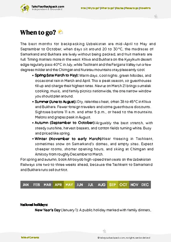
  • Weather: Spring (April to June) and early autumn (September to October) deliver the best conditions. Expect clear skies and dry trails. Summer can scorch with highs hitting 35°C (95°F), while winter plunges below freezing, making the rugged terrain treacherous.

  • Temperature: Daytime highs in spring and autumn hover around 20-25°C (68-77°F), perfect for sustained hiking without overheating or freezing. Nights dip to 5-10°C (41-50°F), so pack layers.

  • Daylight Hours: Spring and autumn offer 10-14 hours of daylight, enough to push deep into the range without rushing. Winter’s short days limit exploration, while summer’s long days come with heat penalties.

  • Crowds: The Gissar Range remains off most tourist radars year-round, but spring and autumn see a slight uptick from local trekkers.
read more 👉

  • Weather: Spring (April to June) and early autumn (September to October) deliver the best conditions. Expect clear skies and dry trails. Summer can scorch with highs hitting 35°C (95°F), while winter plunges below freezing, making the rugged terrain treacherous.

  • Temperature: Daytime highs in spring and autumn hover around 20-25°C (68-77°F), perfect for sustained hiking without overheating or freezing. Nights dip to 5-10°C (41-50°F), so pack layers.

  • Daylight Hours: Spring and autumn offer 10-14 hours of daylight, enough to push deep into the range without rushing. Winter’s short days limit exploration, while summer’s long days come with heat penalties.

  • Crowds: The Gissar Range remains off most tourist radars year-round, but spring and autumn see a slight uptick from local trekkers. You’ll still find plenty of solitude compared to more famous ranges.

  • Seasonal Activities: Spring blooms bring wildflowers and active wildlife, enriching the trail experience. Autumn offers crisp air and vibrant foliage, ideal for photography and campfire evenings.

  • Price Fluctuations: Off-peak seasons (winter and summer) can mean cheaper accommodation and guides, but the trade-off is harsher conditions. Spring and autumn balance cost with comfort and trail access.


Pro-tip: Aim for late April or early October to catch the sweet spot of mild weather, manageable crowds, and the full sensory punch of the Gissar’s wild heart.


source: climatestotravel.comJANJanuary: below average for travelingFEBFebruary: below average for travelingMARMarch: fair for travelingAPRApril: excellent for travelingMAYMay: excellent for travelingJUNJune: highly recommended for travelingJULJuly: fair for travelingAUGAugust: fair for travelingSEPSeptember: excellent for travelingOCTOctober: excellent for travelingNOVNovember: good for travelingDECDecember: below average for traveling
uzbekistan-hike-gissar-range
© Google |

✈️ The backpacker research shortcutUzbekistan Travel Guide

An offline-friendly backpacking guide with optimized travel routes, ranked highlights, transport advice, and the best areas to stay.
example page 0 from our offline Travel Guide for Uzbekistan
example page 1 from our offline Travel Guide for Uzbekistan
example page 2 from our offline Travel Guide for Uzbekistan
example page 3 from our offline Travel Guide for Uzbekistan
example page 4 from our offline Travel Guide for Uzbekistan
example page 5 from our offline Travel Guide for Uzbekistan
example page 6 from our offline Travel Guide for Uzbekistan
example page 7 from our offline Travel Guide for Uzbekistan
The digital guide (394 pages) contains:
110 highlights, ranked by travel appeal
Optimized 5, 10 & 15-day travel routes
Cities, national parks, landmarks, beaches
How to get around
Offline-friendly for travel without Wi-Fi
👉 Click to see all 30+ guide features

📅 Plan smarter in minutes, not weeks
Month by month travel advice
Festivals & national holidays
Budget expectations

🗺️ Go to the right places, skip the overrated ones
Honest pros & cons of destinations
Top hikes, parks & viewpoints
Lesser-known places most travelers miss
Clear “worth it vs skip it” guidance

🛏️ Travel smoothly without rookie mistakes
Best areas to stay
Transport systems explained simply
Common scams & safety advice
SIM cards, money & practical tips

🌍 Understand the country, not just visit it
Culture & traditions
52 Essential phrases & customs
Festivals worth planning around
Traveler-friendly historical context
Insights that make places more meaningful

📱 Built for real travel conditions
Fully downloadable PDF
Works completely offline
Optimized for phone use
Useful in remote areas & buses
Everything in one place
Save weeks of stressful planning
Get instant access to your full guide. 30‑day money-back guarantee.


By proceeding you agree to our terms.
Sent to your inbox immediately after payment • 100% Secure Checkout
Best Backpacking Travel Advisor 2025 tourism awardBest Backpacking
Travel Advisor
2025
What others say about Take Your Backpack Guides:
⭐⭐⭐⭐⭐
Fantastic, amazing amount of information!
⭐⭐⭐⭐⭐
My goodness this is amazing, it's what I've been looking for hats off too you!
⭐⭐⭐⭐⭐
I think this is absolutely BRILLIANT
⭐⭐⭐⭐
Very complete and informative. It's still missing places, but I gotta to commend you
⭐⭐⭐⭐⭐
This is truly amazing, thank you, can't wait to explore it with my kids!
⭐⭐⭐⭐⭐
Awesome resource, thank you!
⭐⭐⭐⭐⭐
This is amazing! Can't wait to explore the ones I haven't seen
⭐⭐⭐⭐
I love this! Well done, great idea.
⭐⭐⭐⭐⭐
Thanks for taking the time to make this gem!
⭐⭐⭐⭐⭐
This might be the best website I've ever seen.
⭐⭐⭐⭐⭐
Congratulations, and thank you so much for your work; it's incredibly valuable.
⭐⭐⭐⭐
In all seriousness I think you did a great job pointing out the important spots
⭐⭐⭐⭐⭐
10/10 very good
⭐⭐⭐⭐⭐
As someone who's only just starting to visit regularly this is awesome, thank you.
⭐⭐⭐⭐
Thank you very much! I'm going to visit my dad, it's going to be very useful!
⭐⭐⭐⭐⭐
This is really cool! We'll be travelling for the first time and this definitely come in handy.
⭐⭐⭐⭐⭐
You are now our minister of culture, congratulations 👨‍💼
⭐⭐⭐⭐⭐
Just wanted to tell you that this is a pearl! Going to follow your recommendations.
⭐⭐⭐⭐⭐
This is so cool. I'll definitely be using the resource for my travels soon.
⭐⭐⭐⭐⭐
This is very impressive! Good work.
⭐⭐⭐⭐⭐
This is an amazing and informative site. Very well done!

🛏️ Where to stay?Best areas and accommodation options

If you enjoy meeting fellow travelers, consider choosing hostels with high ratings for atmosphere. On the other hand, if you prefer having your own space, a hotel might be a better option.

🥾 Hike detailsEverything you need to know before hiking Gissar Range

Total Distance: Approximately 50 kilometers (31 miles) round trip, depending on your chosen route and detours.

Estimated Duration: Expect around 3 to 5 days to complete the hike, factoring in time for rest, exploration, and enjoying the scenery.

Difficulty Level: Moderate to challenging. The trail has some steep sections and can be rocky, so a good level of fitness is recommended.

Starting Point: The trailhead is typically accessed from the town of Gissar.
  • Public Transport: Take a marshrutka (shared taxi) from Tashkent to Gissar, which takes about an hour. Once in Gissar, you might need to grab
read more 👉
Total Distance: Approximately 50 kilometers (31 miles) round trip, depending on your chosen route and detours.

Estimated Duration: Expect around 3 to 5 days to complete the hike, factoring in time for rest, exploration, and enjoying the scenery.

Difficulty Level: Moderate to challenging. The trail has some steep sections and can be rocky, so a good level of fitness is recommended.

Starting Point: The trailhead is typically accessed from the town of Gissar.
  • Public Transport: Take a marshrutka (shared taxi) from Tashkent to Gissar, which takes about an hour. Once in Gissar, you might need to grab a taxi or hitch a ride to the actual trailhead, which is a few kilometers away.

Major Landmarks Along the Route:
  • Gissar Fortress: A historical site worth checking out before you start your hike.
  • Lake Kairak: A stunning spot for a rest and some photos, especially if you’re into birdwatching.
  • Mount Gissar: The highest peak in the range, offering breathtaking views if you venture off the main trail.

Type of Terrain and Scenery: The trail features a mix of rocky paths, grassy meadows, and steep ascents.
  • Terrain: Expect a combination of dirt paths and rocky sections, with some areas requiring careful footing.
  • Scenery: The views are absolutely stunning, with rugged mountains, lush valleys, and clear streams. Sunsets here are something else!

Typical Vegetation and Wildlife: The area is rich in biodiversity.
  • Vegetation: You’ll find alpine meadows, wildflowers, and scattered forests of juniper and oak.
  • Wildlife: Look out for ibex, various birds, and maybe even a shy snow leopard if you’re really lucky!

This trail is a gem for those looking to escape the hustle and bustle and soak in some natural beauty. Just remember to pack enough water and snacks, and maybe a good book for those relaxing moments by the lake.
⚠️ Hiking info can sometimes be outdated or inaccurate. Before you hit the trail, check the latest conditions with locals. If you do spot anything that's off, I'd love to hear from you, so I can update it for fellow travelers.

🛡️ SafetySafety Tips and Common Scams in Gissar Range

The Gissar Range offers a thrilling mix of rugged beauty and manageable challenges. Expect weather shifts; the sun can blaze, then clouds roll in, so pack layers. Altitude isn’t extreme, but you’ll feel it if you push too hard too fast. Take your time, hydrate, and enjoy the views as you climb.

The trails are well-marked but can be steep and rocky. Watch your footing, especially on descents. River crossings are rare but can happen after heavy rains; just scout your path carefully.

Wildlife is present but generally shy. If you spot a marmot or a hawk, admire from a distance. Keep food sealed to avoid attracting curious critters.

Preparation is key. A good pair of trekking poles can save your knees on the way down. Embrace the journey; the payoff is in those sweeping vistas and the cold drink waiting at the end.

Other Uzbek hikes near Gissar Range

Explore more nearby:


💡 Not sure where to go next?
Create a personalized itinerary for Uzbekistan including Gissar Range and the places that fit your trip.

Generate my itinerary

👉 Discover all hikes

Or checkout all Uzbekistan has to offer (think cities, towns, villages, national parks, hikes, beaches, festivals)
Country photo of Uzbekistan

We 💚 feedbackSumming up the experience

The Gissar Range is a raw, rugged beauty that demands your respect. The trails can be unforgiving, but the payoff? Jaw-dropping vistas that make every step worth it. Don’t miss the local shepherds; their hospitality is a warm surprise amidst the wild. Just be ready for the altitude—your lungs will feel it. Pack snacks for the climbs; the cold beer at the end is a well-earned treat. Embrace the grit, and you’ll leave with stories that linger long after you’re home.

✍️ Help improve this page!
The information on this page is based on in-depth research, insights shared by experienced travelers, and feedback from the local travel community in Uzbekistan. While every effort is made to keep the information accurate and current, conditions can change — so if you spot anything incorrect or outdated, please get in touch.


🙋‍♂️ Give feedback

👋 Meet the founderWho’s Behind Take Your Backpack?

Johan, backpacker and founder of TakeYourBackpackHi, I’m Johan (Netherlands 🇳🇱), the creator of TakeYourBackpack. Over the past decade, I’ve backpacked through 80+ countries across six continents, gaining extensive experience with independent travel, long-term trips, and overland routes.

This site is built on a combination of firsthand travel experience and carefully curated insights from other backpackers. Many guides are based on places I’ve personally visited, while others bring together tips, observations, and practical advice shared by trusted travelers I’ve met along the way.

The goal is to provide realistic, experience-driven guidance — not generic itineraries — so you can explore destinations with better context, clearer expectations, and more confidence.

Get full Uzbekistan guide •
Instant download • 110 highlights • Full Offline guide