×

Algeria🇩🇿 | hikesAssekremSunrise plateau, Foucauld hermitage, basalt towers, freezing refuge nights | things to do and best time to go

Explore Djebel CheliaExplore Hoggar Mountains

Backpacking in Assekrem
🏆 Top pickhike ranked #1
By Johan Kruseman 🇳🇱 | Updated October 22, 2026

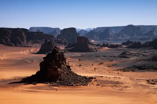
Assekrem sits at roughly 2,780 meters, and the Hoggar nights up there drop below freezing for much of the year, even when Tamanrasset below is baking. Assekrem lies in the Hoggar (Ahaggar) Mountains in the far south of Algeria, about 80 kilometers north of Tamanrasset. The classic hike is short: a 1 to 2 hour scramble up a rocky track from the Refuge d’Assekrem to the summit plateau and Père de Foucauld’s hermitage. The terrain is dry basalt, cold wind and the smell of woodsmoke from the refuge kitchen. The views are huge, with black volcanic needles rising out of a pale sand-colored plain. Getting there is the hard part. Public transport stops in Tamanrasset, and the final stretch needs a 4x4 and, in practice, a local guide and a permit. Sunrise and sunset crowds are small but real. It suits adventurous travelers with time, patience and some cash. It won’t suit anyone who needs a flexible, independent, budget route.

Discover everything you want to know in the 📖 Algeria Travel Guide.
Best time to go: October - April
Duration: 3 hours
Distance: 3 kilometers
Total ascent: 250 meters


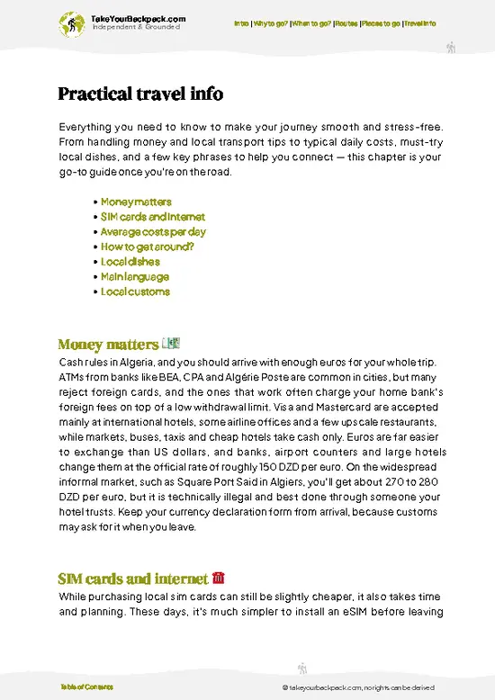
example page 0 from our offline Travel Guide for Algeria
example page 1 from our offline Travel Guide for Algeria
example page 2 from our offline Travel Guide for Algeria
example page 3 from our offline Travel Guide for Algeria
example page 4 from our offline Travel Guide for Algeria
example page 5 from our offline Travel Guide for Algeria
example page 6 from our offline Travel Guide for Algeria
example page 7 from our offline Travel Guide for Algeria
Loading the map 🌍
CLICK TO FILTER
cities
towns
landmarks
national parks
hikes
beaches
attractions
festivals
SHOW COUNTRY’S BESTSHOW ALL

✨ Why go?
Ranked #1 hike in Algeria
What makes this hike worth hiking

Assekrem is the high point of any Hoggar trip, and backpackers chase it for one reason: the sky. At 2,780 meters the plateau gives a view over hundreds of kilometers of volcanic spires, and the refuge lets you sleep close enough to catch both ends of the day without a long walk in the dark. The climb itself is short, so you get a huge payoff for an hour or two of effort, and you save your legs for the longer Tuareg-guided treks that start nearby.

The second pull is the Père de Foucauld hermitage, a small stone building where the French monk lived in the early 1900s. It gives the summit a human story rather than just a view, and the visitors’ book is full of travelers from across the world.

It also fits a Saharan loop well. Most people combine Assekrem with Tamanrasset and the Tuareg villages, … read more 👉
Assekrem is the high point of any Hoggar trip, and backpackers chase it for one reason: the sky. At 2,780 meters the plateau gives a view over hundreds of kilometers of volcanic spires, and the refuge lets you sleep close enough to catch both ends of the day without a long walk in the dark. The climb itself is short, so you get a huge payoff for an hour or two of effort, and you save your legs for the longer Tuareg-guided treks that start nearby.

The second pull is the Père de Foucauld hermitage, a small stone building where the French monk lived in the early 1900s. It gives the summit a human story rather than just a view, and the visitors’ book is full of travelers from across the world.

It also fits a Saharan loop well. Most people combine Assekrem with Tamanrasset and the Tuareg villages, then continue by flight or long overland routes. Expect to pay for guides and vehicles, but the refuge beds are simple and cheap compared with the access costs.

💡 HighlightsKey sights and experiences for travelers

  1. Sunrise and sunset from the Assekrem summit plateau: This is what everyone comes for. From the rim you look across a maze of basalt towers and canyons, and the rock shifts from gray to orange to deep red as the sun moves. The wind is sharp, so bring a hat and gloves.
  2. Père de Foucauld Hermitage: A small, low stone building near the top, built in the early 1900s by Charles de Foucauld, who lived here as a hermit among the Tuareg. The interior is plain and quiet, and a small chapel nearby is still tended by resident priests.
  3. Refuge d’Assekrem: The simple stone refuge below the summit is where hikers sleep, eat and warm up. Dinner is basic and shared, the dormitory is cold, and the star sky outside is some of the clearest you will see anywhere.
  4. Tahat and the Hoggar volcanic towers: From the plateau
… read more 👉
  1. Sunrise and sunset from the Assekrem summit plateau: This is what everyone comes for. From the rim you look across a maze of basalt towers and canyons, and the rock shifts from gray to orange to deep red as the sun moves. The wind is sharp, so bring a hat and gloves.
  2. Père de Foucauld Hermitage: A small, low stone building near the top, built in the early 1900s by Charles de Foucauld, who lived here as a hermit among the Tuareg. The interior is plain and quiet, and a small chapel nearby is still tended by resident priests.
  3. Refuge d’Assekrem: The simple stone refuge below the summit is where hikers sleep, eat and warm up. Dinner is basic and shared, the dormitory is cold, and the star sky outside is some of the clearest you will see anywhere.
  4. Tahat and the Hoggar volcanic towers: From the plateau you can see the jagged volcanic plugs and ridges of the Atakor region, with Tahat (about 2,900 meters, the highest peak in Algeria) rising nearby. These dark spires give the landscape an almost lunar look.
  5. The 4x4 track up from Tamanrasset: The approach itself is a highlight. The rough road climbs through boulder fields, dry riverbeds and the occasional Tuareg camp, and you often spot goats and camels along the way.
Assekrem takes about a day and a night when you combine the track, the hermitage and both ends of the day, with the hiking itself needing only two to three hours.
Spotted a mistake or missing something? Contact us.

🌤️ When to go?Best time to hike the Assekrem

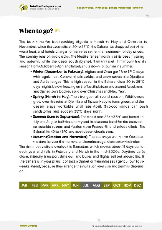
  • Winter (November to February): Clear skies and the best visibility, but the plateau sits at about 2,700 meters (8,860 ft). Days reach 8 to 15°C (46 to 59°F), nights drop to -5 to 2°C (23 to 36°F), and snow or ice can appear. Daylight runs roughly 10 hours. This is peak season for foreign groups, and tour prices in Tamanrasset are at their highest.
  • Spring (March to April): Days of 14 to 22°C (57 to 72°F) and nights of 2 to 8°C (36 to 46°F) make walking easy. Light is long enough for a relaxed afternoon climb to the hermitage. Crowds thin out after the Easter period.
  • Summer (May to August): Hot lowlands and 20 to 28°C (68 to 82°F) on the plateau by day. Haze flattens the views, and tours are scarce and cheaper. Thunderstorms are possible in July and August.
  • Autumn (September to October): Daytime
… read more 👉
  • Winter (November to February): Clear skies and the best visibility, but the plateau sits at about 2,700 meters (8,860 ft). Days reach 8 to 15°C (46 to 59°F), nights drop to -5 to 2°C (23 to 36°F), and snow or ice can appear. Daylight runs roughly 10 hours. This is peak season for foreign groups, and tour prices in Tamanrasset are at their highest.
  • Spring (March to April): Days of 14 to 22°C (57 to 72°F) and nights of 2 to 8°C (36 to 46°F) make walking easy. Light is long enough for a relaxed afternoon climb to the hermitage. Crowds thin out after the Easter period.
  • Summer (May to August): Hot lowlands and 20 to 28°C (68 to 82°F) on the plateau by day. Haze flattens the views, and tours are scarce and cheaper. Thunderstorms are possible in July and August.
  • Autumn (September to October): Daytime temperatures of 16 to 24°C (61 to 75°F), cool nights and sharp air. Daylight is about 11.5 hours, and demand picks up again toward November.
Book your Assekrem vehicle early for November to January, since drivers and guides are in short supply then.


source: climatestotravel.comJANJanuary: excellent for travelingFEBFebruary: excellent for travelingMARMarch: highly recommended for travelingAPRApril: good for travelingMAYMay: fair for travelingJUNJune: below average for travelingJULJuly: below average for travelingAUGAugust: below average for travelingSEPSeptember: fair for travelingOCTOctober: highly recommended for travelingNOVNovember: excellent for travelingDECDecember: excellent for traveling
algeria-hike-assekrem v1
© Google |

✈️ The backpacker research shortcutAlgeria Travel Guide

An offline-friendly backpacking guide with optimized travel routes, ranked highlights, transport advice, and the best areas to stay.
example page 0 from our offline Travel Guide for Algeria
example page 1 from our offline Travel Guide for Algeria
example page 2 from our offline Travel Guide for Algeria
example page 3 from our offline Travel Guide for Algeria
example page 4 from our offline Travel Guide for Algeria
example page 5 from our offline Travel Guide for Algeria
example page 6 from our offline Travel Guide for Algeria
example page 7 from our offline Travel Guide for Algeria
The digital guide (314 pages) contains:
✅ 79 highlights, ranked by travel appeal
✅ Optimized 7, 14 & 21-day travel routes
✅ Cities, national parks, landmarks, beaches
✅ How to get around
✅ Offline-friendly for travel without Wi-Fi
👉 Click to see all 30+ guide features

📅 Plan smarter in minutes, not weeks
✅ Month by month travel advice
✅ Festivals & national holidays
✅ Budget expectations

🗺️ Go to the right places, skip the overrated ones
✅ Honest pros & cons of destinations
✅ Top hikes, parks & viewpoints
✅ Lesser-known places most travelers miss
✅ Clear “worth it vs skip it” guidance

🛏️ Travel smoothly without rookie mistakes
✅ Best areas to stay
✅ Transport systems explained simply
✅ Common scams & safety advice
✅ SIM cards, money & practical tips

🌍 Understand the country, not just visit it
✅ Culture & traditions
✅ 52 Essential phrases & customs
✅ Festivals worth planning around
✅ Traveler-friendly historical context
✅ Insights that make places more meaningful

📱 Built for real travel conditions
✅ Fully downloadable PDF
✅ Works completely offline
✅ Optimized for phone use
✅ Useful in remote areas & buses
✅ Everything in one place
Stop searching, start planning
Get instant access to your full guide. 30‑day money-back guarantee.
+ Add another guide for just

By proceeding you agree to our terms.
Sent to your inbox immediately after payment • 100% Secure Checkout
Best Backpacking Travel Advisor 2025 tourism awardBest Backpacking
Travel Advisor
2025
What others say about Take Your Backpack Guides:
⭐⭐⭐⭐⭐
Fantastic, amazing amount of information!
⭐⭐⭐⭐⭐
My goodness this is amazing, it's what I've been looking for hats off too you!
⭐⭐⭐⭐⭐
I think this is absolutely BRILLIANT
⭐⭐⭐⭐
Very complete and informative. It's still missing places, but I gotta to commend you
⭐⭐⭐⭐⭐
This is truly amazing, thank you, can't wait to explore it with my kids!
⭐⭐⭐⭐⭐
Awesome resource, thank you!
⭐⭐⭐⭐⭐
This is amazing! Can't wait to explore the ones I haven't seen
⭐⭐⭐⭐
I love this! Well done, great idea.
⭐⭐⭐⭐⭐
Thanks for taking the time to make this gem!
⭐⭐⭐⭐⭐
This might be the best website I've ever seen.
⭐⭐⭐⭐⭐
Congratulations, and thank you so much for your work; it's incredibly valuable.
⭐⭐⭐⭐
In all seriousness I think you did a great job pointing out the important spots
⭐⭐⭐⭐⭐
10/10 very good
⭐⭐⭐⭐⭐
As someone who's only just starting to visit regularly this is awesome, thank you.
⭐⭐⭐⭐
Thank you very much! I'm going to visit my dad, it's going to be very useful!
⭐⭐⭐⭐⭐
This is really cool! We'll be travelling for the first time and this definitely come in handy.
⭐⭐⭐⭐⭐
You are now our minister of culture, congratulations 👨‍💼
⭐⭐⭐⭐⭐
Just wanted to tell you that this is a pearl! Going to follow your recommendations.
⭐⭐⭐⭐⭐
This is so cool. I'll definitely be using the resource for my travels soon.
⭐⭐⭐⭐⭐
This is very impressive! Good work.
⭐⭐⭐⭐⭐
This is an amazing and informative site. Very well done!

🛏️ Where to stay?Where staying makes the most sense

If you enjoy meeting fellow travelers, consider choosing hostels with high ratings for atmosphere. On the other hand, if you prefer having your own space, a hotel might be a better option.

🥾 Hike detailsTrail overview: what to expect on the hike

Total Distance: Assekrem is a short summit hike of roughly 2 to 3 kilometers return from the refuge, with a longer option if you walk up from the road.
Estimated Duration: About 1 to 2 hours up and an hour down. Most people stay overnight at the refuge to see both sunset and sunrise.
Difficulty: Easy to moderate. The path is rocky and steep in places, and the altitude of roughly 2,780 meters and the cold make it feel harder than the distance suggests.
Starting Point: Assekrem is reached from Tamanrasset, which has flights and long-distance buses from the north. From there you need a 4x4 transfer,
… read more 👉
Total Distance: Assekrem is a short summit hike of roughly 2 to 3 kilometers return from the refuge, with a longer option if you walk up from the road.
Estimated Duration: About 1 to 2 hours up and an hour down. Most people stay overnight at the refuge to see both sunset and sunrise.
Difficulty: Easy to moderate. The path is rocky and steep in places, and the altitude of roughly 2,780 meters and the cold make it feel harder than the distance suggests.
Starting Point: Assekrem is reached from Tamanrasset, which has flights and long-distance buses from the north. From there you need a 4x4 transfer, normally arranged through a local guide or agency, as there is no regular public service up the mountain.
Major Landmarks:
  • Refuge d’Assekrem: Basic shelter at the trailhead with beds, blankets and meals.
  • Summit plateau: A broad rocky viewpoint with open views over the Atakor volcanic region.
  • Hermitage of Charles de Foucauld: A small stone building and chapel near the top.
Terrain and Scenery: Dark basalt and phonolite rock, loose gravel, and steep stepped sections. The surroundings are a maze of tall volcanic spires and deep valleys that glow orange at the ends of the day.
Vegetation: Sparse. Expect dry grasses, hardy shrubs and a few acacias lower down, with almost nothing on the summit itself.
Wildlife: Mostly domestic animals such as goats and camels around the approach. Birds like ravens and desert larks are common, and small lizards sun themselves on the rocks.
Practical Notes: Bring warm layers, a sleeping bag liner and a headlamp. Nights are cold, water is limited, and a guide and permit are normally required for travel in the Hoggar.
⚠️ Hiking info can sometimes be outdated or inaccurate. Before you hit the trail, check the latest conditions with locals. If you do spot anything that's off, I'd love to hear from you, so I can update it for fellow travelers.

🛡️ SafetyTraveler Safety Guide

Assekrem is a high-altitude plateau in the Hoggar mountains, and the main hazards are cold, sun and remoteness rather than the trail itself. At roughly 2,700 meters, nights are freezing from November to February, so bring a proper sleeping bag rated to -5°C (23°F), a warm hat and insulated layers. The refuge near Père de Foucauld’s hermitage is basic, so carry extra water, snacks and a headlamp. The final climb is short but steep over loose volcanic rock, so wear boots with grip and move slowly if you arrive from Tamanrasset’s lower elevation. Navigation off the track is difficult because the landscape looks alike in every direction, and there is little phone signal. Go with a local guide and driver, who know the tracks and can respond if a vehicle breaks down. Strong sun and dry air dehydrate … read more 👉
Assekrem is a high-altitude plateau in the Hoggar mountains, and the main hazards are cold, sun and remoteness rather than the trail itself. At roughly 2,700 meters, nights are freezing from November to February, so bring a proper sleeping bag rated to -5°C (23°F), a warm hat and insulated layers. The refuge near Père de Foucauld’s hermitage is basic, so carry extra water, snacks and a headlamp. The final climb is short but steep over loose volcanic rock, so wear boots with grip and move slowly if you arrive from Tamanrasset’s lower elevation. Navigation off the track is difficult because the landscape looks alike in every direction, and there is little phone signal. Go with a local guide and driver, who know the tracks and can respond if a vehicle breaks down. Strong sun and dry air dehydrate you quickly, so drink steadily. Wildlife is minimal and rarely an issue. Check current travel advisories and local conditions before departure, as regional rules can affect access.

FAQFrequently asked questions about Assekrem

Assekrem is usually done as a 2 to 3 day trip from Tamanrasset. The drive covers about 80 kilometers and takes 3 to 4 hours each way on a mix of paved and rough track. Most groups sleep at the refuge near the hermitage to catch sunrise and sunset, then climb the last 30 to 45 minutes on foot. Some trekkers extend the journey to 4 to 7 days with hiking across the Atakor volcanic massif.
Assekrem is an easy to moderate outing, with a short but steep final climb of 30 to 45 minutes on loose volcanic rock. The main challenge is the altitude of about 2,700 meters and the cold, which can fall below freezing on winter nights. Fitness requirements are low, but longer treks across the Hoggar plateau demand stamina and multi-day carrying. Most of the difficulty comes from rough roads and remote conditions rather than technical terrain.
Assekrem requires a local guide and driver in practice, because independent travel in the Hoggar region is restricted and the tracks are poorly marked. Foreigners generally arrange everything through a licensed agency in Tamanrasset, which handles permits and police registration. Expect to pay about US$80 to 150 per person per day for a 4x4, guide, food and refuge accommodation, with group size lowering the price. Arrange paperwork before you arrive, since processing takes some time.
⚠️ Things can change over time, so always validate details locally before you go.

Other Algerian hikes near Assekrem

Explore more nearby:

  • Hoggar Mountains—volcanic peaks, ancient rock art, deep valleys| 10 km away
  • Djebel Chelia—highest summit, steep ascents, panoramic outlooks| 1344 km away
  • Atlas Mountains—broad ridgelines, Berber villages, seasonal rivers| 1408 km away

💡 Not sure where to go next?
Create a personalized itinerary for Algeria including Assekrem and the places that fit your trip.

Generate my itinerary

👉 Discover all hikes

Or checkout all Algeria has to offer (think cities, towns, villages, national parks, hikes, beaches, festivals)
Country photo of Algeria

We 💚 feedbackFinal thoughts on hiking the Assekrem

Assekrem catches people out when they treat it as a quick sunrise stop and drive up from Tamanrasset the same morning. You miss the best light and arrive cold and rushed. Sleep at the refuge instead, pack a proper warm layer and a hat, and give the sky an evening as well as a dawn.

✍️ Help improve this page!
The information on this page is based on in-depth research, insights shared by experienced travelers, and feedback from the local travel community in Algeria. While every effort is made to keep the information accurate and current, conditions can change — so if you spot anything incorrect or outdated, please get in touch.


🙋‍♂️ Give feedback

👋 Meet the founderWho’s Behind Take Your Backpack?

Johan, backpacker and founder of TakeYourBackpackHi, I’m Johan (Netherlands 🇳🇱), the creator of TakeYourBackpack. Over the past 3 decades, I’ve backpacked through 90+ countries across six continents, gaining extensive experience with independent travel, long-term trips, and overland routes.

This site is built on a combination of firsthand travel experience and carefully curated insights from other backpackers. Many guides are based on places I’ve personally visited, while others bring together tips, observations, and practical advice shared by trusted travelers I’ve met along the way.

The goal is to provide realistic, experience-driven guidance — not generic itineraries — so you can explore destinations with better context, clearer expectations, and more confidence.