×

Djibouti🇩🇯 | national parksGoda MountainsGoda summit ridge, Bankoualé valley, Afar herders, gulf lookouts | things to do and best time to go

Explore Day Forest National ParkExplore Moucha Island National Park

Backpacking in Goda Mountains
🌟 Highlightnational park ranked #3
By Johan Kruseman 🇳🇱 | Updated October 22, 2026

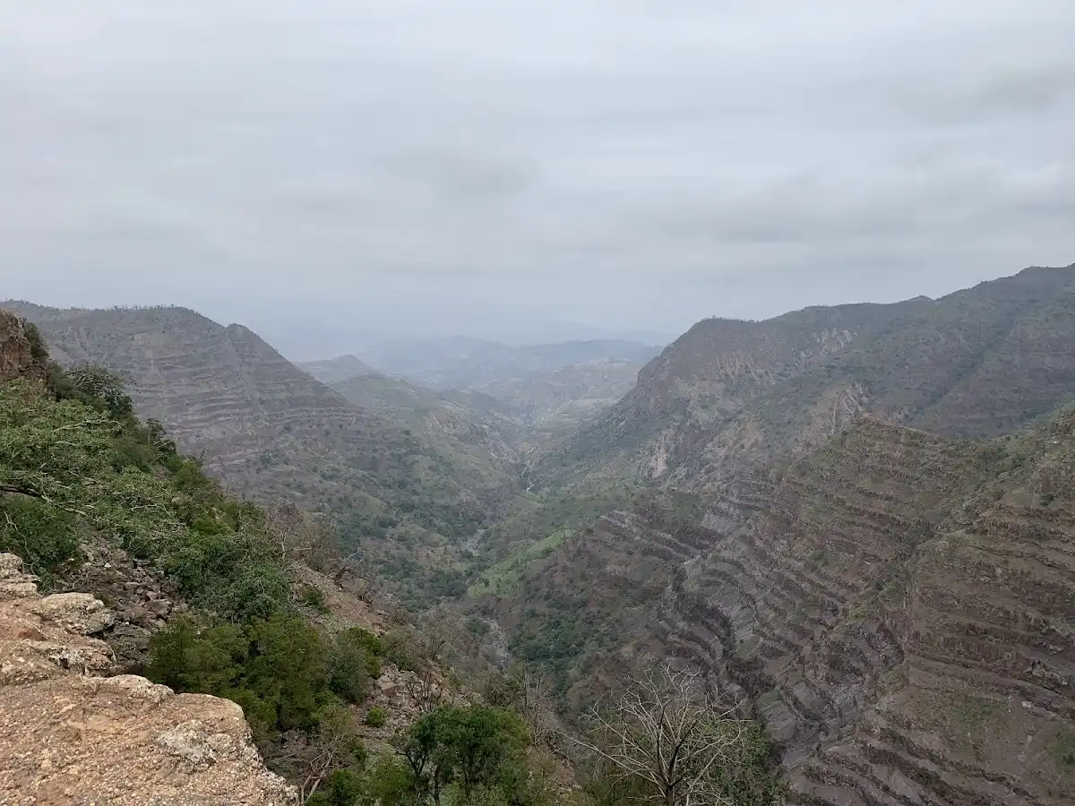
Goda Mountains are cool, green and forested, with juniper woodland between roughly 1,500 and 1,780 meters, which makes the highlands noticeably milder than the baking coast far below. They sit in the north of Djibouti, northwest of Djibouti City, above the Gulf of Tadjoura. The massif holds Day Forest National Park, the country’s best-known patch of old-growth woodland. Hiking here means ridge walks, goat tracks and dry stream beds, with long views over the gulf and the Afar lowlands. Wildlife is modest but notable, led by the critically endangered Djibouti francolin. Access is the sticking point: tracks are rough, signage is thin and a 4x4 with a local driver is the realistic option. Crowds are close to nonexistent, so the mood is quiet, with herders and goats as your main company. A first day could mean an early drive up, a slow loop through the junipers, a tea stop in a village and a ridge viewpoint before dusk.

Discover everything you want to know in the 📖 Djibouti Travel Guide.


example page 0 from our offline Travel Guide for Djibouti
example page 1 from our offline Travel Guide for Djibouti
example page 2 from our offline Travel Guide for Djibouti
example page 3 from our offline Travel Guide for Djibouti
example page 4 from our offline Travel Guide for Djibouti
example page 5 from our offline Travel Guide for Djibouti
example page 6 from our offline Travel Guide for Djibouti
example page 7 from our offline Travel Guide for Djibouti
Loading the map 🌍
CLICK TO FILTER
cities
towns
villages
landmarks
national parks
hikes
beaches
attractions
festivals
regions
SHOW COUNTRY’S BESTSHOW ALL

✨ Why go?
Ranked #3 national park in Djibouti
Why visitors keep coming back

Goda Mountains suit backpackers who want to walk somewhere that almost no one else is walking. The Day Forest juniper woodland is a rare sight in the Horn of Africa, and the shade, the cool air and the smell of resin make a startling change after the salt flats and lava fields lower down. You will see signs of the Djibouti francolin, a bird found almost nowhere else, and birders come for it alone.

Independence is the main draw. There are no ticket gates, no queues and no guided-group schedules, so you set your own pace along herder paths and ridgelines. The flip side is that you need to plan your own transport and carry your own food and water. Nearby villages sell basics, and local families will often point you toward a good route. Self-guided travelers with some navigation sense and a hired … read more 👉
Goda Mountains suit backpackers who want to walk somewhere that almost no one else is walking. The Day Forest juniper woodland is a rare sight in the Horn of Africa, and the shade, the cool air and the smell of resin make a startling change after the salt flats and lava fields lower down. You will see signs of the Djibouti francolin, a bird found almost nowhere else, and birders come for it alone.

Independence is the main draw. There are no ticket gates, no queues and no guided-group schedules, so you set your own pace along herder paths and ridgelines. The flip side is that you need to plan your own transport and carry your own food and water. Nearby villages sell basics, and local families will often point you toward a good route. Self-guided travelers with some navigation sense and a hired driver will get far more out of this than any package tour could offer, and the quiet is the bonus.

💡 HighlightsDon't-miss highlights and experiences

  1. Day Forest National Park: The reason most people come. Ancient Juniperus procera and wild olive form a dense, shaded woodland on the massif’s upper slopes, with moss-draped branches and a cool, damp feel that is almost unheard of in Djibouti.
  2. Djibouti francolin: A secretive, critically endangered bird that lives in this forest. Listen for its calls at first light and scan the undergrowth quietly. Even a glimpse is a prize for birders.
  3. Goda summit ridge: The highest ground in the massif, near 1,780 meters. The walk along the crest gives wide views across rocky ravines and out toward the Gulf of Tadjoura.
  4. Bankoualé valley: A deep, steep-sided valley on the massif’s edge, where palms and green pockets contrast with bare red rock. It is a good place for a slow walk and some photography.
  5. Day village:
… read more 👉
  1. Day Forest National Park: The reason most people come. Ancient Juniperus procera and wild olive form a dense, shaded woodland on the massif’s upper slopes, with moss-draped branches and a cool, damp feel that is almost unheard of in Djibouti.
  2. Djibouti francolin: A secretive, critically endangered bird that lives in this forest. Listen for its calls at first light and scan the undergrowth quietly. Even a glimpse is a prize for birders.
  3. Goda summit ridge: The highest ground in the massif, near 1,780 meters. The walk along the crest gives wide views across rocky ravines and out toward the Gulf of Tadjoura.
  4. Bankoualé valley: A deep, steep-sided valley on the massif’s edge, where palms and green pockets contrast with bare red rock. It is a good place for a slow walk and some photography.
  5. Day village: A small highland settlement where Afar herding families live among the junipers. Stop for sweet tea, watch the goats come in and get a sense of life at altitude.
  6. Gulf of Tadjoura viewpoints: Open ledges on the northern and eastern flanks look down over the blue water and the dry, folded land below. The contrast between cool forest and the heat haze beneath is the best photograph in the range.
Goda Mountains reward a single day that pairs the Day Forest walk with a tea stop in Day village, since the village sits close to the forest edge.
Spotted a mistake or missing something? Contact us.

Things to do near Goda Mountains

Ratings based on Tripadvisor reviews. When you book through this link, you support our work at no extra cost to you.

🌤️ When to go?Weather, crowds, and seasonal trade-offs

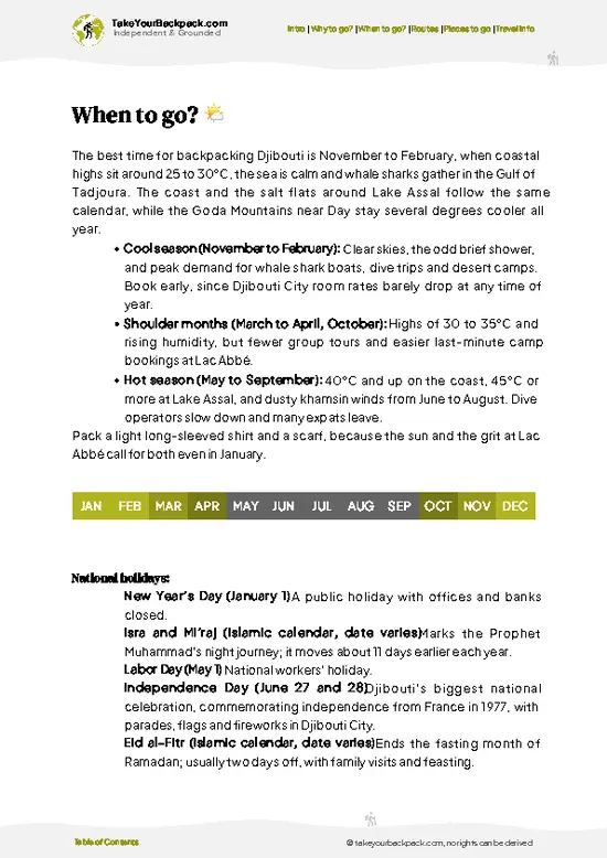
  • Cool Season (October to March): Goda Mountains is most workable for hiking from November through February, with highland mornings around 15 to 22°C (59 to 72°F) and afternoons of 25 to 30°C (77 to 86°F). The Day Forest at around 1,500 meters stays noticeably cooler than the coast.
  • Hot Season (May to September): Lowland approaches reach 38 to 45°C (100 to 113°F), and the highlands still hit 28 to 34°C (82 to 93°F) by midday. Trekking is limited to dawn hours, and the hot khamsin wind dries out the trails.
  • Rains (March to April, with brief showers in July and August): Rainfall is low and erratic, but sudden downpours can flood wadis and make dirt tracks impassable for a day.
  • Daylight and Crowds: Daylight is close to 12 hours all year. Visitors are few in any month, and lodging prices barely move,
… read more 👉
  • Cool Season (October to March): Goda Mountains is most workable for hiking from November through February, with highland mornings around 15 to 22°C (59 to 72°F) and afternoons of 25 to 30°C (77 to 86°F). The Day Forest at around 1,500 meters stays noticeably cooler than the coast.
  • Hot Season (May to September): Lowland approaches reach 38 to 45°C (100 to 113°F), and the highlands still hit 28 to 34°C (82 to 93°F) by midday. Trekking is limited to dawn hours, and the hot khamsin wind dries out the trails.
  • Rains (March to April, with brief showers in July and August): Rainfall is low and erratic, but sudden downpours can flood wadis and make dirt tracks impassable for a day.
  • Daylight and Crowds: Daylight is close to 12 hours all year. Visitors are few in any month, and lodging prices barely move, though 4x4 hire and guide fees climb a bit around December holidays.
Plan your hike for the first three hours after dawn, whatever the month.


source: climatestotravel.comJANJanuary: excellent for travelingFEBFebruary: excellent for travelingMARMarch: good for travelingAPRApril: fair for travelingMAYMay: fair for travelingJUNJune: below average for travelingJULJuly: below average for travelingAUGAugust: below average for travelingSEPSeptember: fair for travelingOCTOctober: good for travelingNOVNovember: highly recommended for travelingDECDecember: excellent for traveling
djibouti-national-park-goda-mountains
© Google |

✈️ The backpacker research shortcutDjibouti Travel Guide

An offline-friendly backpacking guide with optimized travel routes, ranked highlights, transport advice, and the best areas to stay.
example page 0 from our offline Travel Guide for Djibouti
example page 1 from our offline Travel Guide for Djibouti
example page 2 from our offline Travel Guide for Djibouti
example page 3 from our offline Travel Guide for Djibouti
example page 4 from our offline Travel Guide for Djibouti
example page 5 from our offline Travel Guide for Djibouti
example page 6 from our offline Travel Guide for Djibouti
example page 7 from our offline Travel Guide for Djibouti
The digital guide (186 pages) contains:
✅ 44 highlights, ranked by travel appeal
✅ Optimized 2, 3 & 5-day travel routes
✅ Cities, national parks, landmarks, beaches
✅ How to get around
✅ Offline-friendly for travel without Wi-Fi
👉 Click to see all 30+ guide features

📅 Plan smarter in minutes, not weeks
✅ Month by month travel advice
✅ Festivals & national holidays
✅ Budget expectations

🗺️ Go to the right places, skip the overrated ones
✅ Honest pros & cons of destinations
✅ Top hikes, parks & viewpoints
✅ Lesser-known places most travelers miss
✅ Clear “worth it vs skip it” guidance

🛏️ Travel smoothly without rookie mistakes
✅ Best areas to stay
✅ Transport systems explained simply
✅ Common scams & safety advice
✅ SIM cards, money & practical tips

🌍 Understand the country, not just visit it
✅ Culture & traditions
✅ 52 Essential phrases & customs
✅ Festivals worth planning around
✅ Traveler-friendly historical context
✅ Insights that make places more meaningful

📱 Built for real travel conditions
✅ Fully downloadable PDF
✅ Works completely offline
✅ Optimized for phone use
✅ Useful in remote areas & buses
✅ Everything in one place
Stop searching, start planning
Get instant access to your full guide. 30‑day money-back guarantee.
+ Add another guide for just

By proceeding you agree to our terms.
Sent to your inbox immediately after payment • 100% Secure Checkout
Best Backpacking Travel Advisor 2025 tourism awardBest Backpacking
Travel Advisor
2025
What others say about Take Your Backpack Guides:
⭐⭐⭐⭐⭐
Fantastic, amazing amount of information!
⭐⭐⭐⭐⭐
My goodness this is amazing, it's what I've been looking for hats off too you!
⭐⭐⭐⭐⭐
I think this is absolutely BRILLIANT
⭐⭐⭐⭐
Very complete and informative. It's still missing places, but I gotta to commend you
⭐⭐⭐⭐⭐
This is truly amazing, thank you, can't wait to explore it with my kids!
⭐⭐⭐⭐⭐
Awesome resource, thank you!
⭐⭐⭐⭐⭐
This is amazing! Can't wait to explore the ones I haven't seen
⭐⭐⭐⭐
I love this! Well done, great idea.
⭐⭐⭐⭐⭐
Thanks for taking the time to make this gem!
⭐⭐⭐⭐⭐
This might be the best website I've ever seen.
⭐⭐⭐⭐⭐
Congratulations, and thank you so much for your work; it's incredibly valuable.
⭐⭐⭐⭐
In all seriousness I think you did a great job pointing out the important spots
⭐⭐⭐⭐⭐
10/10 very good
⭐⭐⭐⭐⭐
As someone who's only just starting to visit regularly this is awesome, thank you.
⭐⭐⭐⭐
Thank you very much! I'm going to visit my dad, it's going to be very useful!
⭐⭐⭐⭐⭐
This is really cool! We'll be travelling for the first time and this definitely come in handy.
⭐⭐⭐⭐⭐
You are now our minister of culture, congratulations 👨‍💼
⭐⭐⭐⭐⭐
Just wanted to tell you that this is a pearl! Going to follow your recommendations.
⭐⭐⭐⭐⭐
This is so cool. I'll definitely be using the resource for my travels soon.
⭐⭐⭐⭐⭐
This is very impressive! Good work.
⭐⭐⭐⭐⭐
This is an amazing and informative site. Very well done!

🛏️ Where to stay?Best areas and accommodation options

The best base for Goda Mountains is Tadjoura, a small coastal town on the Gulf of Tadjoura, with the nearest real alternative being Djibouti City. Inside the Day Forest National Park area there are no hotels, but basic eco-lodge style stays and village homestays exist around Day and Bankoualé, plus simple camping if you arrange it with a local guide.

Tadjoura has a handful of modest guesthouses and small hotels near the old whitewashed center and waterfront, with rooms at roughly US$25 to 60 a night. Most are simple, with fans or air conditioning and a basic breakfast. From here you can organize … read more 👉
The best base for Goda Mountains is Tadjoura, a small coastal town on the Gulf of Tadjoura, with the nearest real alternative being Djibouti City. Inside the Day Forest National Park area there are no hotels, but basic eco-lodge style stays and village homestays exist around Day and Bankoualé, plus simple camping if you arrange it with a local guide.

Tadjoura has a handful of modest guesthouses and small hotels near the old whitewashed center and waterfront, with rooms at roughly US$25 to 60 a night. Most are simple, with fans or air conditioning and a basic breakfast. From here you can organize a 4x4 and guide up to the highlands, usually a few hours on rough tracks.

Djibouti City has the widest choice, from hostel-style guesthouses and budget hotels at around US$30 to 70 to pricier options. It makes sense if you are arriving by air or want to compare tour operators before heading north. The trip to Tadjoura combines a road drive with a ferry option across the gulf.

If you want a night in the mountains, ask your guide about sleeping in a village house or camping near the forest. Bring your own sleeping bag, because nights at altitude can turn cool.

👛 Costs (as of 22 October 2026)How expensive it really is

Goda Mountains costs roughly US$80 to 190 a day for a backpacker, with a guide and transport making up most of that. Prices are for the high (cool) season.
CategoryBudget RangeLocal Reality
Entrance and PermitsUS$0 to 10Formal fees are small or collected informally through your guide, so ask when booking.
GuideUS$25 to 50Strongly advisable for navigation and village access, often cheaper when split in a group.
Accommodation (high season)US$25 to 50Tadjoura guesthouses are simple but adequate. Village stays or camping cost less.
Accommodation (low season)US$20 to 40Slightly lower rates in the hot months, with fewer visitors.
Local TransportUS$20 to 60Shared taxis run to Tadjoura, but reaching the highlands usually needs a chartered 4x4, shared among passengers.
Food and WaterUS$10 to 20Fish, rice,
… read more 👉
Goda Mountains costs roughly US$80 to 190 a day for a backpacker, with a guide and transport making up most of that. Prices are for the high (cool) season.
CategoryBudget RangeLocal Reality
Entrance and PermitsUS$0 to 10Formal fees are small or collected informally through your guide, so ask when booking.
GuideUS$25 to 50Strongly advisable for navigation and village access, often cheaper when split in a group.
Accommodation (high season)US$25 to 50Tadjoura guesthouses are simple but adequate. Village stays or camping cost less.
Accommodation (low season)US$20 to 40Slightly lower rates in the hot months, with fewer visitors.
Local TransportUS$20 to 60Shared taxis run to Tadjoura, but reaching the highlands usually needs a chartered 4x4, shared among passengers.
Food and WaterUS$10 to 20Fish, rice, flatbread and stews in local restaurants. Carry bottled water, which is pricey.
Total Daily BudgetUS$80 to 190Costs fall noticeably when you split guide and vehicle with others.
⚠️ Prices can change and everyone travels differently, so take this as a rough guide. Hope it helps you plan your adventure!

🥾 TrailsExploring Goda Mountains: trails, terrain, and views

Goda Mountains offer walking that is more about wandering than ticking off numbered routes, and terrain ranges from soft forest floor to loose rock and steep, dry gullies. Walkers here follow herder paths, so what you do depends on your driver, your guide and your legs.
  • Forest loop: Most people start near the Day Forest edge and wander a loop through the junipers. It is easy to moderate, usually two to four hours depending on how long you linger, on shaded, uneven ground with some gentle climbs.
  • Summit ridge walk: A longer, moderate to demanding day on exposed ground, with loose stones and little
… read more 👉
Goda Mountains offer walking that is more about wandering than ticking off numbered routes, and terrain ranges from soft forest floor to loose rock and steep, dry gullies. Walkers here follow herder paths, so what you do depends on your driver, your guide and your legs.
  • Forest loop: Most people start near the Day Forest edge and wander a loop through the junipers. It is easy to moderate, usually two to four hours depending on how long you linger, on shaded, uneven ground with some gentle climbs.
  • Summit ridge walk: A longer, moderate to demanding day on exposed ground, with loose stones and little shade. Views open up toward the gulf and the lowlands. Start early and allow most of a day.
  • Valley walks: Paths drop into Bankoualé and neighboring ravines. Descents are steep and the climb back is tiring. Expect one to three hours, with palm groves and rock walls as the main interest.
  • Wildlife: Listen for the Djibouti francolin at dawn. Baboons and small antelope may appear in quiet spots, and birdlife is richer in the forest than anywhere else nearby.
  • Difficulty: Fitness needs are modest for the forest and high for the ridge. Altitude is mild, but the sun and dry air are tiring, so carry water and food for the whole outing.
Getting there is the hard part. No scheduled public transport climbs into the massif, so most travelers hire a 4x4 and driver in Tadjoura or arrange a guide in advance. The tracks are rough and can be washed out after rain. Crowds are minimal, and you may meet only herders and a few birders. Carry a paper or offline map, cash for villages and some food, since village shops are basic.
⚠️ Hiking info can sometimes be outdated or inaccurate. Before you hit the trail, check the latest conditions with locals. If you do spot anything that's off, I'd love to hear from you, so I can update it for fellow travelers.

🛡️ SafetyStaying Safe: What Travelers Should Know

Goda Mountains is generally calm for hikers, and the main hazards are heat, dehydration and getting lost, not people or wildlife. Go with a local guide, which is effectively standard here. Trails are lightly marked, tracks fork often, and phone signal is patchy. Footing is rocky and loose on steep sections, so wear sturdy shoes with grip and carry trekking poles if your knees complain on descents.

Heat builds fast, even in the highlands, so start at dawn, finish before midday, and carry more water than seems reasonable, at least 3 liters per person for a full day. Add a hat, sun protection and electrolytes. Flash floods can fill dry riverbeds after rain, so avoid camping in wadis.

Wildlife encounters are uncommon. Baboons may approach for food, so keep snacks sealed, and watch for scorpions … read more 👉
Goda Mountains is generally calm for hikers, and the main hazards are heat, dehydration and getting lost, not people or wildlife. Go with a local guide, which is effectively standard here. Trails are lightly marked, tracks fork often, and phone signal is patchy. Footing is rocky and loose on steep sections, so wear sturdy shoes with grip and carry trekking poles if your knees complain on descents.

Heat builds fast, even in the highlands, so start at dawn, finish before midday, and carry more water than seems reasonable, at least 3 liters per person for a full day. Add a hat, sun protection and electrolytes. Flash floods can fill dry riverbeds after rain, so avoid camping in wadis.

Wildlife encounters are uncommon. Baboons may approach for food, so keep snacks sealed, and watch for scorpions and snakes by checking shoes and not putting hands under rocks. Tell someone your route, and stay clear of the Eritrean and Ethiopian border zones as advised locally.

FAQFrequently asked questions about Goda Mountains

Plan two to three days for Goda Mountains, which gives you one full day of hiking and travel time from Tadjoura. A one-night stay in the highlands near Day lets you hike at dawn before the heat builds. Add a day if you want to include the Day Forest and surrounding villages at an easy pace.
Without a car, Goda Mountains is difficult but possible with local help. Shared taxis and minibuses link Djibouti City and Tadjoura, but the final highland tracks need a 4x4. Most backpackers hire a vehicle and guide in Tadjoura for roughly US$40 to 100 a day, shared among passengers.
Goda Mountains has no strict permit system for most hikers, and any fees are small, typically US$0 to 10, often arranged through your guide. Hiring a local guide is effectively expected and costs about US$25 to 50 a day. Carry your passport and keep a copy, since checkpoints exist on roads toward the north.
⚠️ Things can change over time, so always validate details locally before you go.

Other Djiboutian national parks near Goda Mountains

Explore more nearby:


💡 Not sure where to go next?
Create a personalized itinerary for Djibouti including Goda Mountains and the places that fit your trip.

Generate my itinerary

👉 Discover all national parks

Or checkout all Djibouti has to offer (think cities, towns, villages, national parks, hikes, beaches, festivals)
Country photo of Djibouti

We 💚 feedbackWhat to keep in mind

Goda Mountains are at their best at dawn, when the juniper forest is cold, wet with mist and loud with birds. I would go in winter, between roughly November and March, when the ridges are comfortable for long walks. Bring a warm layer for the early start, because it can feel chilly up there, and hire a driver who knows the tracks.

✍️ Help improve this page!
The information on this page is based on in-depth research, insights shared by experienced travelers, and feedback from the local travel community in Djibouti. While every effort is made to keep the information accurate and current, conditions can change — so if you spot anything incorrect or outdated, please get in touch.


🙋‍♂️ Give feedback

👋 Meet the founderWho’s Behind Take Your Backpack?

Johan, backpacker and founder of TakeYourBackpackHi, I’m Johan (Netherlands 🇳🇱), the creator of TakeYourBackpack. Over the past 3 decades, I’ve backpacked through 90+ countries across six continents, gaining extensive experience with independent travel, long-term trips, and overland routes.

This site is built on a combination of firsthand travel experience and carefully curated insights from other backpackers. Many guides are based on places I’ve personally visited, while others bring together tips, observations, and practical advice shared by trusted travelers I’ve met along the way.

The goal is to provide realistic, experience-driven guidance — not generic itineraries — so you can explore destinations with better context, clearer expectations, and more confidence.