×

The Netherlands🇳🇱 | hikesPieterpadWadden Sea marsh, Groningen, Drenthe heath, Sint Pietersberg | things to do and best time to go

Explore NS Walk VeluwezoomExplore Sprengenberg Route (Sallandse Heuvelrug)

Backpacking in Pieterpad
🏆 Top pickhike ranked #1
By Johan Kruseman 🇳🇱 | Updated October 15, 2026

Steam lifts off a slice of warm apple pie in a Pieterburen café, the first fork cracks through a sugary crust, and the sea wind outside smells of mud and salt. The bill for pie and coffee was about €7.50, which is a decent guide to prices along the whole route. Pieterburen sits on the Wadden Sea coast in Groningen province, in the far north of the Netherlands, and the Pieterpad runs about 498 km south from here to Sint Pietersberg by Maastricht. The pattern is simple. The north is flat, open and quiet, Drenthe adds heath and forest, and the south brings real hills. The downsides are long stretches of farm lanes and some asphalt, plus a thin choice of lodging in rural gaps. Trains and buses reach most stage ends, and Groningen to the start is one regional bus. It is gentler and better waymarked than the Dutch coastal trails.

Discover everything you want to know in the 📖 The Netherlands Travel Guide.


example page 0 from our offline Travel Guide for Netherlands
example page 1 from our offline Travel Guide for Netherlands
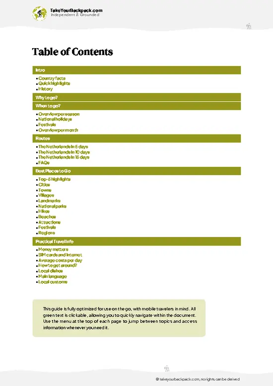
example page 2 from our offline Travel Guide for Netherlands
example page 3 from our offline Travel Guide for Netherlands
example page 4 from our offline Travel Guide for Netherlands
example page 5 from our offline Travel Guide for Netherlands
example page 6 from our offline Travel Guide for Netherlands
example page 7 from our offline Travel Guide for Netherlands
Loading the map 🌍
CLICK TO FILTER
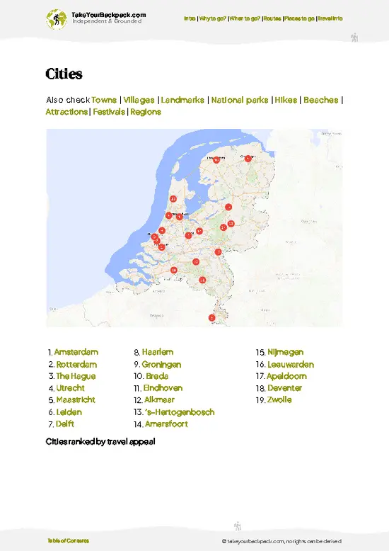
cities
towns
villages
landmarks
national parks
hikes
beaches
attractions
festivals
regions
SHOW COUNTRY’S BESTSHOW ALL

✨ Why go?
Ranked #1 hike in The Netherlands
What sets this place apart

Backpackers choose the Pieterpad because the Netherlands changes more along this line than its size suggests. In a few weeks you pass from the Wadden Sea mudflats at Pieterburen through heath, river valleys and the Sallandse Heuvelrug, and finish above the Maas on Sint Pietersberg. That gradual shift makes the walk feel like a real crossing of a country.

The second reason is flexibility. The trail is split into 26 stages, nearly all ending at a train or bus stop, so you can walk a weekend, a week, or the full route over several trips. Daily distances of 15 to 25 km let you stretch or shorten as legs and weather allow.

The third reason is ease. Red and white waymarks, detailed guidebooks and apps, and plenty of B&Bs, campsites and cafés mean a first long-distance hiker can manage it without … read more 👉
Backpackers choose the Pieterpad because the Netherlands changes more along this line than its size suggests. In a few weeks you pass from the Wadden Sea mudflats at Pieterburen through heath, river valleys and the Sallandse Heuvelrug, and finish above the Maas on Sint Pietersberg. That gradual shift makes the walk feel like a real crossing of a country.

The second reason is flexibility. The trail is split into 26 stages, nearly all ending at a train or bus stop, so you can walk a weekend, a week, or the full route over several trips. Daily distances of 15 to 25 km let you stretch or shorten as legs and weather allow.

The third reason is ease. Red and white waymarks, detailed guidebooks and apps, and plenty of B&Bs, campsites and cafés mean a first long-distance hiker can manage it without special gear. Experienced walkers use it as a calm warm-up for tougher routes.

💡 HighlightsWhat this place is best known for

  1. Wadden Sea salt marshes at Pieterburen: The trail begins beside the Wadden Sea, with kwelder (salt marsh) grazed by sheep and a huge sky over the mudflats. At low tide you can see why the area is a UNESCO World Heritage site.
  2. Zeehondencentrum Pieterburen: The seal rehabilitation center near the start cares for injured and orphaned seals, and it gives you a nice reason to linger before setting off.
  3. Groningen city: The route passes through a lively university city, with canals, cafés and a large food market. It is a practical rest day with banks, shops and trains.
  4. Drenthe heath and forest: South of Groningen the path crosses heath, woodland and quiet villages. The landscape is quieter and more varied than the arable north, with sandy paths underfoot.
  5. Sint Pietersberg above Maastricht: The finish
… read more 👉
  1. Wadden Sea salt marshes at Pieterburen: The trail begins beside the Wadden Sea, with kwelder (salt marsh) grazed by sheep and a huge sky over the mudflats. At low tide you can see why the area is a UNESCO World Heritage site.
  2. Zeehondencentrum Pieterburen: The seal rehabilitation center near the start cares for injured and orphaned seals, and it gives you a nice reason to linger before setting off.
  3. Groningen city: The route passes through a lively university city, with canals, cafés and a large food market. It is a practical rest day with banks, shops and trains.
  4. Drenthe heath and forest: South of Groningen the path crosses heath, woodland and quiet villages. The landscape is quieter and more varied than the arable north, with sandy paths underfoot.
  5. Sint Pietersberg above Maastricht: The finish lies on a limestone plateau above the Maas, with old quarry tunnels beneath and a view toward Belgium. After weeks of flat ground, the climb and the sense of arriving are memorable.
For a first visit, the Wadden Sea salt marshes at Pieterburen are the best choice, since they set the scale of the whole walk and need no more than the first morning.
Spotted a mistake or missing something? Contact us.

Things to do near Pieterpad

Ratings based on Tripadvisor reviews. When you book through this link, you support our work at no extra cost to you.

🌤️ When to go?Weather, crowds, and seasonal trade-offs

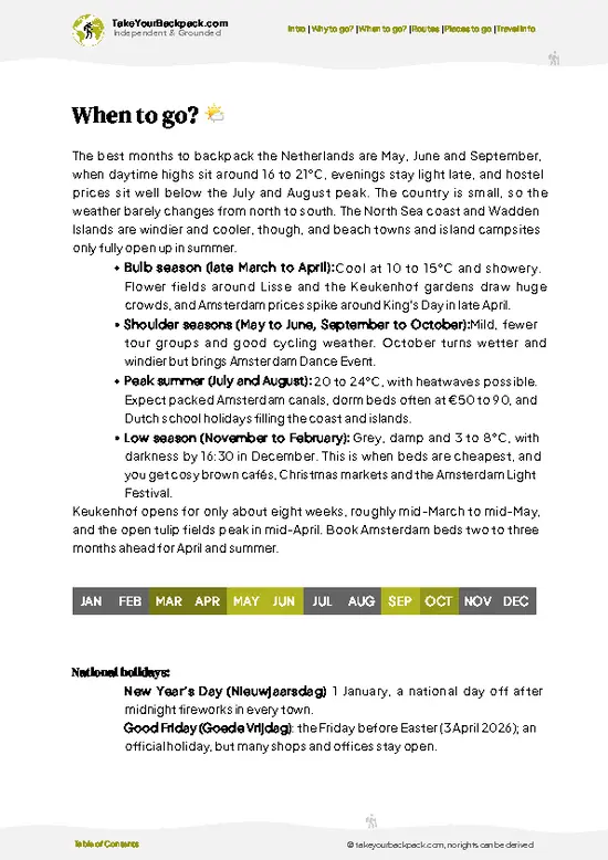
  • Spring (April to May): The best window for the Pieterpad, which runs about 485 km from Pieterburen to Mount Saint Peter near Maastricht. Days run 8 to 15°C (46 to 59°F) early on and reach 18 to 20°C (64 to 68°F) by late May, with 13 to 16 hours of daylight. Fields are green, lambs are out, and the Groningen coast has few walkers.
  • Summer (June to August): Highs of 20 to 25°C (68 to 77°F), with occasional heat waves above 30°C (86°F). Daylight lasts 16 to 17 hours. Showers are common, and accommodation near Maastricht and in Limburg costs more and fills up on weekends.
  • Autumn (September to October): Temperatures of 10 to 18°C (50 to 64°F), softer light, and fewer walkers. Daylight shrinks from 13 to 10 hours, and rain becomes more frequent. Prices ease after mid-September.
  • Winter (November to March):
… read more 👉
  • Spring (April to May): The best window for the Pieterpad, which runs about 485 km from Pieterburen to Mount Saint Peter near Maastricht. Days run 8 to 15°C (46 to 59°F) early on and reach 18 to 20°C (64 to 68°F) by late May, with 13 to 16 hours of daylight. Fields are green, lambs are out, and the Groningen coast has few walkers.
  • Summer (June to August): Highs of 20 to 25°C (68 to 77°F), with occasional heat waves above 30°C (86°F). Daylight lasts 16 to 17 hours. Showers are common, and accommodation near Maastricht and in Limburg costs more and fills up on weekends.
  • Autumn (September to October): Temperatures of 10 to 18°C (50 to 64°F), softer light, and fewer walkers. Daylight shrinks from 13 to 10 hours, and rain becomes more frequent. Prices ease after mid-September.
  • Winter (November to March): Temperatures of 0 to 6°C (32 to 43°F), with 8 hours of daylight in December. Wind is raw on the open northern polders, paths turn muddy, and some B&Bs and cafes close, so beds are harder to find.
Book beds early for May and June weekends, or go in late April for the quietest spring walking.


source: climatestotravel.comJANJanuary: below average for travelingFEBFebruary: below average for travelingMARMarch: good for travelingAPRApril: highly recommended for travelingMAYMay: excellent for travelingJUNJune: highly recommended for travelingJULJuly: good for travelingAUGAugust: good for travelingSEPSeptember: excellent for travelingOCTOctober: highly recommended for travelingNOVNovember: fair for travelingDECDecember: below average for traveling
netherlands-hike-pieterpad v1
© Google |

✈️ The backpacker research shortcutThe Netherlands Travel Guide

An offline-friendly backpacking guide with optimized travel routes, ranked highlights, transport advice, and the best areas to stay.
example page 0 from our offline Travel Guide for Netherlands
example page 1 from our offline Travel Guide for Netherlands
example page 2 from our offline Travel Guide for Netherlands
example page 3 from our offline Travel Guide for Netherlands
example page 4 from our offline Travel Guide for Netherlands
example page 5 from our offline Travel Guide for Netherlands
example page 6 from our offline Travel Guide for Netherlands
example page 7 from our offline Travel Guide for Netherlands
The digital guide (373 pages) contains:
✅ 127 highlights, ranked by travel appeal
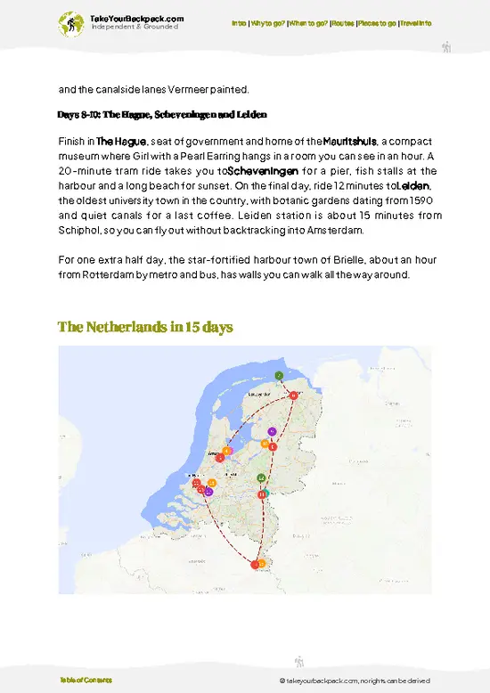
✅ Optimized 5, 10 & 15-day travel routes
✅ Cities, national parks, landmarks, beaches
✅ How to get around
✅ Offline-friendly for travel without Wi-Fi
👉 Click to see all 30+ guide features

📅 Plan smarter in minutes, not weeks
✅ Month by month travel advice
✅ Festivals & national holidays
✅ Budget expectations

🗺️ Go to the right places, skip the overrated ones
✅ Honest pros & cons of destinations
✅ Top hikes, parks & viewpoints
✅ Lesser-known places most travelers miss
✅ Clear “worth it vs skip it” guidance

🛏️ Travel smoothly without rookie mistakes
✅ Best areas to stay
✅ Transport systems explained simply
✅ Common scams & safety advice
✅ SIM cards, money & practical tips

🌍 Understand the country, not just visit it
✅ Culture & traditions
✅ 52 Essential phrases & customs
✅ Festivals worth planning around
✅ Traveler-friendly historical context
✅ Insights that make places more meaningful

📱 Built for real travel conditions
✅ Fully downloadable PDF
✅ Works completely offline
✅ Optimized for phone use
✅ Useful in remote areas & buses
✅ Everything in one place
Stop searching, start planning
Get instant access to your full guide. 30‑day money-back guarantee.
+ Add another guide for just

By proceeding you agree to our terms.
Sent to your inbox immediately after payment • 100% Secure Checkout
Best Backpacking Travel Advisor 2025 tourism awardBest Backpacking
Travel Advisor
2025
What others say about Take Your Backpack Guides:
⭐⭐⭐⭐⭐
Fantastic, amazing amount of information!
⭐⭐⭐⭐⭐
My goodness this is amazing, it's what I've been looking for hats off too you!
⭐⭐⭐⭐⭐
I think this is absolutely BRILLIANT
⭐⭐⭐⭐
Very complete and informative. It's still missing places, but I gotta to commend you
⭐⭐⭐⭐⭐
This is truly amazing, thank you, can't wait to explore it with my kids!
⭐⭐⭐⭐⭐
Awesome resource, thank you!
⭐⭐⭐⭐⭐
This is amazing! Can't wait to explore the ones I haven't seen
⭐⭐⭐⭐
I love this! Well done, great idea.
⭐⭐⭐⭐⭐
Thanks for taking the time to make this gem!
⭐⭐⭐⭐⭐
This might be the best website I've ever seen.
⭐⭐⭐⭐⭐
Congratulations, and thank you so much for your work; it's incredibly valuable.
⭐⭐⭐⭐
In all seriousness I think you did a great job pointing out the important spots
⭐⭐⭐⭐⭐
10/10 very good
⭐⭐⭐⭐⭐
As someone who's only just starting to visit regularly this is awesome, thank you.
⭐⭐⭐⭐
Thank you very much! I'm going to visit my dad, it's going to be very useful!
⭐⭐⭐⭐⭐
This is really cool! We'll be travelling for the first time and this definitely come in handy.
⭐⭐⭐⭐⭐
You are now our minister of culture, congratulations 👨‍💼
⭐⭐⭐⭐⭐
Just wanted to tell you that this is a pearl! Going to follow your recommendations.
⭐⭐⭐⭐⭐
This is so cool. I'll definitely be using the resource for my travels soon.
⭐⭐⭐⭐⭐
This is very impressive! Good work.
⭐⭐⭐⭐⭐
This is an amazing and informative site. Very well done!

🛏️ Where to stay?Best areas and accommodation options

If you enjoy meeting fellow travelers, consider choosing hostels with high ratings for atmosphere. On the other hand, if you prefer having your own space, a hotel might be a better option.

🥾 Hike detailsHike details: route, duration, and difficulty of Pieterpad

Total Distance: About 498 km from Pieterburen to Sint Pietersberg, divided into 26 official stages.
Estimated Duration: Roughly 20 to 26 walking days at 18 to 25 km a day. Many people spread it over several trips.
Difficulty: Easy to moderate. Navigation is straightforward and climbs are rare, but the daily distances and the surfaces add up.
Starting Point: Pieterburen, on the Wadden Sea coast.
  • Public Transport: Take a train to Groningen, then a regional bus to Pieterburen. The ride takes under an hour.
  • Finish: Sint Pietersberg, reached from Maastricht station, with onward trains from there.
Major Landmarks:
  • Pieterburen:
… read more 👉
Total Distance: About 498 km from Pieterburen to Sint Pietersberg, divided into 26 official stages.
Estimated Duration: Roughly 20 to 26 walking days at 18 to 25 km a day. Many people spread it over several trips.
Difficulty: Easy to moderate. Navigation is straightforward and climbs are rare, but the daily distances and the surfaces add up.
Starting Point: Pieterburen, on the Wadden Sea coast.
  • Public Transport: Take a train to Groningen, then a regional bus to Pieterburen. The ride takes under an hour.
  • Finish: Sint Pietersberg, reached from Maastricht station, with onward trains from there.
Major Landmarks:
  • Pieterburen: Wadden coast, salt marshes and the seal center.
  • Groningen: The main city of the north.
  • Drenthe: Heath, forest and small villages.
  • Sallandse Heuvelrug: Wooded hills in the east.
  • Maas and Limburg: River crossings and the final hills.
Terrain and Scenery: Mostly flat in the north and center, on farm tracks, dikes, forest paths and some paved roads. Hills appear in the east and south, and the route finishes with rolling Limburg countryside.
Vegetation: Salt marsh grasses on the coast, then pasture and arable fields, pine and mixed forest, purple heather in late summer, and river meadows.
Wildlife: Seals on the Wadden Sea, geese and wading birds on the mudflats and fields, deer in forests, and many small farmland birds.
Waymarking: Red and white markers. A guidebook or app helps in towns.
Permits and Fees: None needed.
⚠️ Hiking info can sometimes be outdated or inaccurate. Before you hit the trail, check the latest conditions with locals. If you do spot anything that's off, I'd love to hear from you, so I can update it for fellow travelers.

🛡️ SafetyStaying Safe: What Travelers Should Know

The Pieterpad is a safe, well-marked path with red-and-white waymarks, so most trouble comes from weather and blisters rather than danger. Wind and rain sweep the open northern farmland with no shelter, so carry a proper rain jacket and layers even in summer. Clay paths in Groningen and Drenthe turn slick and heavy after rain, and trail shoes with decent grip help more than stiff boots. Much of the route crosses fields with livestock, and cows with calves can be protective, so give them space and keep dogs leashed. In the Limburg hills, wet descents and sunken lanes need slower steps. Ticks live in heathland and tall grass from spring to autumn, so wear long trousers and check your skin each evening. Villages are spaced closely, but shops and cafes can be shut on Sundays and Mondays, so carry … read more 👉
The Pieterpad is a safe, well-marked path with red-and-white waymarks, so most trouble comes from weather and blisters rather than danger. Wind and rain sweep the open northern farmland with no shelter, so carry a proper rain jacket and layers even in summer. Clay paths in Groningen and Drenthe turn slick and heavy after rain, and trail shoes with decent grip help more than stiff boots. Much of the route crosses fields with livestock, and cows with calves can be protective, so give them space and keep dogs leashed. In the Limburg hills, wet descents and sunken lanes need slower steps. Ticks live in heathland and tall grass from spring to autumn, so wear long trousers and check your skin each evening. Villages are spaced closely, but shops and cafes can be shut on Sundays and Mondays, so carry water and snacks. Bring a GPS app or the official guide as backup. Emergency number: 112.

FAQCommon questions from travelers

Walking the whole Pieterpad takes roughly 20 to 26 days at 18 to 25 km a day. The route covers about 498 km from Pieterburen to Sint Pietersberg near Maastricht, in 26 official stages. Many hikers walk it in sections over several seasons, and a single stage is easily done in a day.
The Pieterpad is easy to moderate. Terrain is mostly flat and waymarking is clear in red and white, but the daily distances of 15 to 25 km and paved sections tire the feet over weeks. The only real hills come in the east and in Limburg near Maastricht.
No guide and no permit are needed for the Pieterpad, and there is no fee for walking it. The path is waymarked with red and white markers and covered by guidebooks and apps. Book accommodation ahead in busy months, as small villages may have only a few B&Bs.
⚠️ Things can change over time, so always validate details locally before you go.

Other Dutch hikes near Pieterpad

Explore more nearby:


💡 Not sure where to go next?
Create a personalized itinerary for The Netherlands including Pieterpad and the places that fit your trip.

Generate my itinerary

👉 Discover all hikes

Or checkout all The Netherlands has to offer (think cities, towns, villages, national parks, hikes, beaches, festivals)
Country photo of The Netherlands

We 💚 feedbackKey takeaways before you go

The Pieterpad suits people who like steady walking, small-town cafés and slow changes in landscape more than dramatic peaks. It is excellent for first-time long-distance hikers, retirees, and anyone who wants to cross a country in sections. If you want alpine drama, look elsewhere. The north can feel flat and windy, and some road sections are dull. Come for the rhythm and the pie stops.

✈️ When did I visit The Netherlands?
Netherlands is my home base, so whenever I don’t travel, you can find me in this tiny spot on the globe. When friends from abroad visit me, it’s the time to actually explore my own country as a traveler.

✍️ Help improve this page!
The information on this page is based on my own backpacking experience in The Netherlands, supplemented with up-to-date research and feedback from other travelers. Travel details can change, so if you notice anything outdated or incomplete, feel free to let me know.


🙋‍♂️ Give feedback

👋 Meet the founderWho’s Behind Take Your Backpack?

Johan, backpacker and founder of TakeYourBackpackHi, I’m Johan (Netherlands 🇳🇱), the creator of TakeYourBackpack. Over the past 3 decades, I’ve backpacked through 90+ countries across six continents, gaining extensive experience with independent travel, long-term trips, and overland routes.

This site is built on a combination of firsthand travel experience and carefully curated insights from other backpackers. Many guides are based on places I’ve personally visited, while others bring together tips, observations, and practical advice shared by trusted travelers I’ve met along the way.

The goal is to provide realistic, experience-driven guidance — not generic itineraries — so you can explore destinations with better context, clearer expectations, and more confidence.