×

Réunion🇷🇪 | hikesSentier ScoutSun-baked ascent, Mafate overlook, Îlet à Malheur, Aurère gîtes | things to do and best time to go

Explore Piton des NeigesExplore Cirque de Cilaos

Backpacking in Sentier Scout
👌 Worth visitinghike ranked #3
By Johan Kruseman 🇳🇱 | Updated October 22, 2026

Sentier Scout is open to every hiker, and you don’t need any scouting link to walk it. It runs through the Cirque de Mafate in the west of Réunion, a roadless basin you enter only on foot. Expect a long climb up dry, sun-baked slopes where the air smells of hot rock and dust, then cooler ridges with wind in the tamarind and casuarina. The views are big and the footing is rough, with loose gravel on the steep sections and a hard, shadeless first stretch. Public transport reaches the lower valley, but the last stretch to the trailhead is yours to sort out, so check the last bus before you set off. Start early, carry more water than looks sensible (at least 2 liters), and book mountain huts ahead, because Mafate beds fill and there’s no road out. Unlike the busier Col des Bœufs approach, Sentier Scout is quieter and tougher.

Discover everything you want to know in the 📖 Réunion Travel Guide.
Best time to go: April - December
Duration: 6 hours
Distance: 11 kilometers
Total ascent: 1200 meters


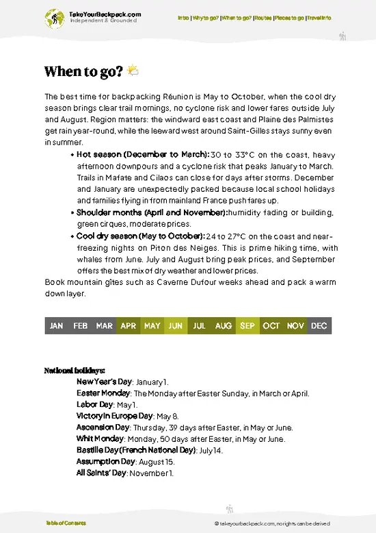
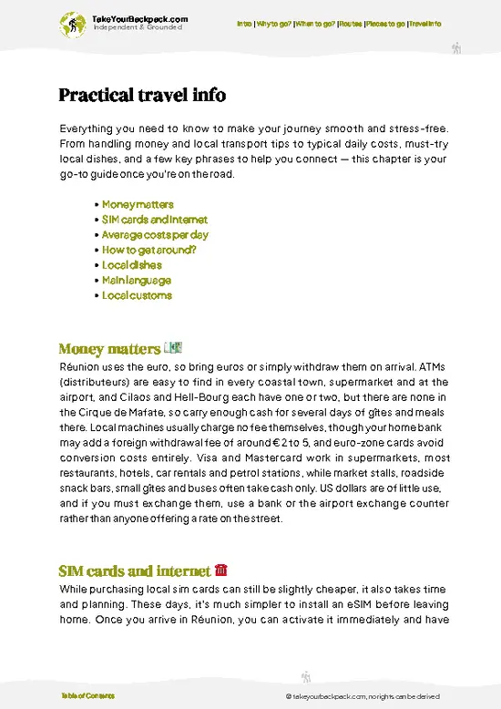
example page 0 from our offline Travel Guide for Réunion
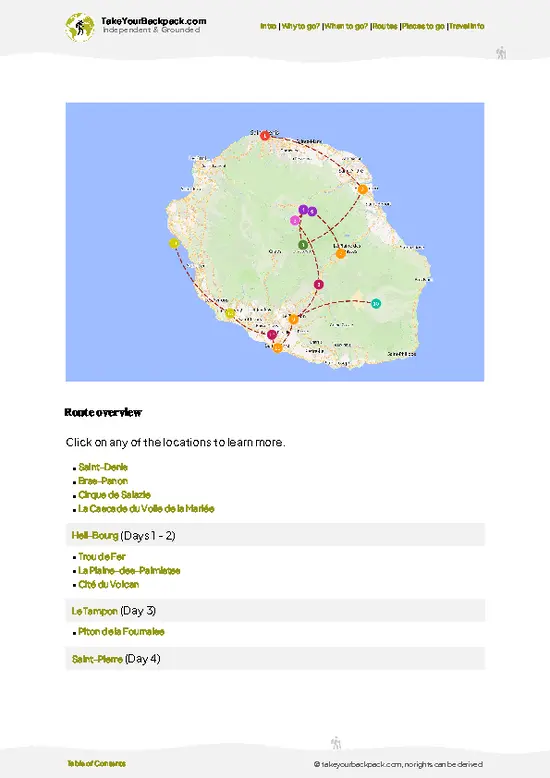
example page 1 from our offline Travel Guide for Réunion
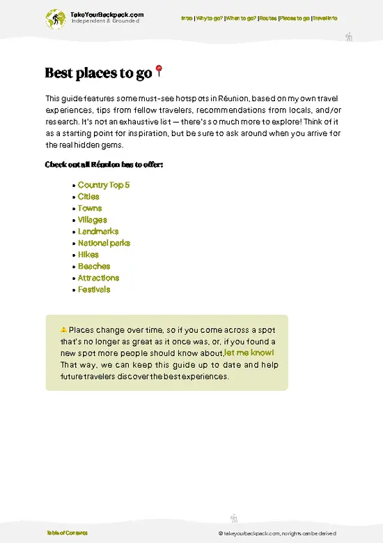
example page 2 from our offline Travel Guide for Réunion
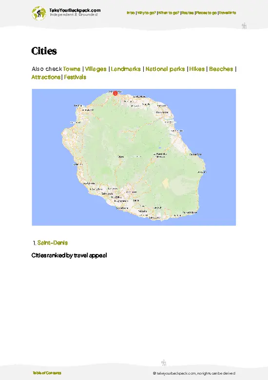
example page 3 from our offline Travel Guide for Réunion
example page 4 from our offline Travel Guide for Réunion
example page 5 from our offline Travel Guide for Réunion
example page 6 from our offline Travel Guide for Réunion
example page 7 from our offline Travel Guide for Réunion
Loading the map 🌍
CLICK TO FILTER
cities
towns
villages
landmarks
national parks
hikes
beaches
attractions
festivals
SHOW COUNTRY’S BESTSHOW ALL

✨ Why go?
Ranked #3 hike in Réunion
Why visitors keep coming back

Sentier Scout gives you a back door into Mafate that most visitors never use, and that is the main reason hikers seek it out. The climb is steep, around 1,200 meters of ascent, so you earn the cirque rather than reach it by a short, popular path. Because you arrive from the Rivière des Galets side, you see the landscape change from dry lowland scrub to cooler, greener ridges as you gain height, and you share the path with far fewer people than on the better-known entries. It also fits neatly into a longer route. Once you’re in the cirque, you can link on to Aurère and the Îlet à Malheur area, overnight in a mountain hut, and walk out by another trail the next day. Distances are flexible, so you can stop early at a village or push on. Everything beyond the trailhead is on foot, which gives … read more 👉
Sentier Scout gives you a back door into Mafate that most visitors never use, and that is the main reason hikers seek it out. The climb is steep, around 1,200 meters of ascent, so you earn the cirque rather than reach it by a short, popular path. Because you arrive from the Rivière des Galets side, you see the landscape change from dry lowland scrub to cooler, greener ridges as you gain height, and you share the path with far fewer people than on the better-known entries. It also fits neatly into a longer route. Once you’re in the cirque, you can link on to Aurère and the Îlet à Malheur area, overnight in a mountain hut, and walk out by another trail the next day. Distances are flexible, so you can stop early at a village or push on. Everything beyond the trailhead is on foot, which gives the trip a proper expedition feel without needing a vehicle or a guide.

💡 HighlightsThe experiences that define the visit

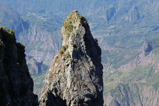
  1. Cirque de Mafate panorama: The reason most people come. Once the climb levels out, the cirque opens up below you, a bowl of knife-edged ridges, deep ravines and tiny settlements with no road in sight. Morning light is clearest, before cloud fills the basin.
  2. Rivière des Galets valley: The opening stretch follows the dry, stony valley, where heat bounces off the rock and the vegetation is sparse. Looking back down the valley as you climb shows how much height you’ve gained, and the sea shows in the distance.
  3. Îlet à Malheur: One of Mafate’s small hamlets, with scattered houses, vegetable plots and a quiet, unhurried feel. It’s a good place to rest, refill water and see how people live without roads, with all supplies carried in on foot or by helicopter.
  4. Aurère: A small settlement in the cirque that
… read more 👉
  1. Cirque de Mafate panorama: The reason most people come. Once the climb levels out, the cirque opens up below you, a bowl of knife-edged ridges, deep ravines and tiny settlements with no road in sight. Morning light is clearest, before cloud fills the basin.
  2. Rivière des Galets valley: The opening stretch follows the dry, stony valley, where heat bounces off the rock and the vegetation is sparse. Looking back down the valley as you climb shows how much height you’ve gained, and the sea shows in the distance.
  3. Îlet à Malheur: One of Mafate’s small hamlets, with scattered houses, vegetable plots and a quiet, unhurried feel. It’s a good place to rest, refill water and see how people live without roads, with all supplies carried in on foot or by helicopter.
  4. Aurère: A small settlement in the cirque that makes a natural stop or overnight. Gîtes serve hearty Creole meals, usually rice with a slow-cooked rougail, which taste far better after a day of climbing.
Sentier Scout is best started at dawn with the Rivière des Galets valley, since the lower slopes are exposed and the first hours are the only comfortable ones.
Spotted a mistake or missing something? Contact us.

🌤️ When to go?Best time to hike the Sentier Scout

  • Austral Winter (May to October): Clear mornings, low humidity and the most stable trail conditions. Days run about 18 to 24°C (64 to 75°F) at lower elevations, and nights drop to 8 to 13°C (46 to 55°F) higher up. Daylight lasts roughly 11 hours, so start early.
  • Summer (November to April): Hot and humid at 26 to 32°C (79 to 90°F), with afternoon storms building over the cirque. Cyclone risk peaks January to March, and trails or river crossings can close with little notice.
  • School Holidays (July to August, mid-December to early January): Mafate gîtes and weekend trails fill up, and half-board beds run about €45 to 65. Book weeks ahead.
  • Shoulder Months (May, June, September, October): Quieter paths, easier booking and comfortable walking temperatures.
Walk on a weekday in September or October and … read more 👉
  • Austral Winter (May to October): Clear mornings, low humidity and the most stable trail conditions. Days run about 18 to 24°C (64 to 75°F) at lower elevations, and nights drop to 8 to 13°C (46 to 55°F) higher up. Daylight lasts roughly 11 hours, so start early.
  • Summer (November to April): Hot and humid at 26 to 32°C (79 to 90°F), with afternoon storms building over the cirque. Cyclone risk peaks January to March, and trails or river crossings can close with little notice.
  • School Holidays (July to August, mid-December to early January): Mafate gîtes and weekend trails fill up, and half-board beds run about €45 to 65. Book weeks ahead.
  • Shoulder Months (May, June, September, October): Quieter paths, easier booking and comfortable walking temperatures.
Walk on a weekday in September or October and you get the best mix of dry trail, space in the gîtes and long enough light.


source: climatestotravel.comJANJanuary: fair for travelingFEBFebruary: fair for travelingMARMarch: fair for travelingAPRApril: good for travelingMAYMay: excellent for travelingJUNJune: excellent for travelingJULJuly: highly recommended for travelingAUGAugust: highly recommended for travelingSEPSeptember: excellent for travelingOCTOctober: excellent for travelingNOVNovember: excellent for travelingDECDecember: good for traveling
reunion-hike-sentier-scout v1
© Google |

✈️ The backpacker research shortcutRéunion Travel Guide

An offline-friendly backpacking guide with optimized travel routes, ranked highlights, transport advice, and the best areas to stay.
example page 0 from our offline Travel Guide for Réunion
example page 1 from our offline Travel Guide for Réunion
example page 2 from our offline Travel Guide for Réunion
example page 3 from our offline Travel Guide for Réunion
example page 4 from our offline Travel Guide for Réunion
example page 5 from our offline Travel Guide for Réunion
example page 6 from our offline Travel Guide for Réunion
example page 7 from our offline Travel Guide for Réunion
The digital guide (232 pages) contains:
✅ 64 highlights, ranked by travel appeal
✅ Optimized 2, 3 & 5-day travel routes
✅ Cities, national parks, landmarks, beaches
✅ How to get around
✅ Offline-friendly for travel without Wi-Fi
👉 Click to see all 30+ guide features

📅 Plan smarter in minutes, not weeks
✅ Month by month travel advice
✅ Festivals & national holidays
✅ Budget expectations

🗺️ Go to the right places, skip the overrated ones
✅ Honest pros & cons of destinations
✅ Top hikes, parks & viewpoints
✅ Lesser-known places most travelers miss
✅ Clear “worth it vs skip it” guidance

🛏️ Travel smoothly without rookie mistakes
✅ Best areas to stay
✅ Transport systems explained simply
✅ Common scams & safety advice
✅ SIM cards, money & practical tips

🌍 Understand the country, not just visit it
✅ Culture & traditions
✅ 52 Essential phrases & customs
✅ Festivals worth planning around
✅ Traveler-friendly historical context
✅ Insights that make places more meaningful

📱 Built for real travel conditions
✅ Fully downloadable PDF
✅ Works completely offline
✅ Optimized for phone use
✅ Useful in remote areas & buses
✅ Everything in one place
Stop searching, start planning
Get instant access to your full guide. 30‑day money-back guarantee.
+ Add another guide for just

By proceeding you agree to our terms.
Sent to your inbox immediately after payment • 100% Secure Checkout
Best Backpacking Travel Advisor 2025 tourism awardBest Backpacking
Travel Advisor
2025
What others say about Take Your Backpack Guides:
⭐⭐⭐⭐⭐
Fantastic, amazing amount of information!
⭐⭐⭐⭐⭐
My goodness this is amazing, it's what I've been looking for hats off too you!
⭐⭐⭐⭐⭐
I think this is absolutely BRILLIANT
⭐⭐⭐⭐
Very complete and informative. It's still missing places, but I gotta to commend you
⭐⭐⭐⭐⭐
This is truly amazing, thank you, can't wait to explore it with my kids!
⭐⭐⭐⭐⭐
Awesome resource, thank you!
⭐⭐⭐⭐⭐
This is amazing! Can't wait to explore the ones I haven't seen
⭐⭐⭐⭐
I love this! Well done, great idea.
⭐⭐⭐⭐⭐
Thanks for taking the time to make this gem!
⭐⭐⭐⭐⭐
This might be the best website I've ever seen.
⭐⭐⭐⭐⭐
Congratulations, and thank you so much for your work; it's incredibly valuable.
⭐⭐⭐⭐
In all seriousness I think you did a great job pointing out the important spots
⭐⭐⭐⭐⭐
10/10 very good
⭐⭐⭐⭐⭐
As someone who's only just starting to visit regularly this is awesome, thank you.
⭐⭐⭐⭐
Thank you very much! I'm going to visit my dad, it's going to be very useful!
⭐⭐⭐⭐⭐
This is really cool! We'll be travelling for the first time and this definitely come in handy.
⭐⭐⭐⭐⭐
You are now our minister of culture, congratulations 👨‍💼
⭐⭐⭐⭐⭐
Just wanted to tell you that this is a pearl! Going to follow your recommendations.
⭐⭐⭐⭐⭐
This is so cool. I'll definitely be using the resource for my travels soon.
⭐⭐⭐⭐⭐
This is very impressive! Good work.
⭐⭐⭐⭐⭐
This is an amazing and informative site. Very well done!

🛏️ Where to stay?Best areas and accommodation options

If you enjoy meeting fellow travelers, consider choosing hostels with high ratings for atmosphere. On the other hand, if you prefer having your own space, a hotel might be a better option.

🥾 Hike detailsHike details: route, duration, and difficulty of Sentier Scout

Total Distance: Sentier Scout covers roughly 11 kilometers one way, with variations depending on where you finish in the cirque.
Estimated Duration: About 6 hours of walking one way at a steady pace, longer with heavy packs and photo stops.
Difficulty: Demanding. The ascent is around 1,200 meters, much of it steep and exposed. Good boots and fitness are needed.
Starting Point: The trail begins on the Rivière des Galets side, in the Sans-Souci area of La Possession. Urban buses serve the lower valley, but you may have to walk or take a taxi for the last stretch to the start.
Major Landmarks:
  • Rivière
… read more 👉
Total Distance: Sentier Scout covers roughly 11 kilometers one way, with variations depending on where you finish in the cirque.
Estimated Duration: About 6 hours of walking one way at a steady pace, longer with heavy packs and photo stops.
Difficulty: Demanding. The ascent is around 1,200 meters, much of it steep and exposed. Good boots and fitness are needed.
Starting Point: The trail begins on the Rivière des Galets side, in the Sans-Souci area of La Possession. Urban buses serve the lower valley, but you may have to walk or take a taxi for the last stretch to the start.
Major Landmarks:
  • Rivière des Galets valley: The dry, rocky start with long views down toward the coast.
  • Mafate rim: The point where the cirque appears below you.
  • Îlet à Malheur and Aurère: Hamlets with gîtes, meals and water.
Terrain and Scenery: Stony path, loose gravel, rock steps and narrow ledges, with big views across ridges and ravines.
Vegetation: Dry scrub and grasses on the lower slopes, then tamarind, casuarina and greener forest on the higher ground.
Wildlife: Mostly birds, including the white-tailed tropicbird gliding along cliff faces. Mafate has no dangerous large animals, but wasps and mosquitoes can be a nuisance.
Practical Notes: Carry plenty of water for the lower section, wear a hat and sun protection, and start early. Reserve gîtes in advance and bring cash, as there are no shops on the route and the cirque has no road access.
⚠️ Hiking info can sometimes be outdated or inaccurate. Before you hit the trail, check the latest conditions with locals. If you do spot anything that's off, I'd love to hear from you, so I can update it for fellow travelers.

🛡️ SafetySafety Tips and Common Scams in Sentier Scout

Sentier Scout is a steep, well-trodden mountain path, and most problems come from heat, sun and underestimating the climbing. Much of the route is exposed, so start early, carry at least 2 to 3 liters of water, and wear a hat and sunscreen. Footing is loose on dry gravel sections and slick after rain, so trail shoes with real grip and trekking poles help on the descents. Afternoon cloud and showers roll in fast, especially in summer. Skip the route when heavy rain is forecast, since ravines flood quickly and cell signal is patchy in the cirque. Paths are marked, but fog can hide junctions, so download an offline map. No dangerous wildlife lives on the island. Take your trash out, stay on the path and leave plants alone. Book gîtes ahead, because there are no shops along the trail, and bring … read more 👉
Sentier Scout is a steep, well-trodden mountain path, and most problems come from heat, sun and underestimating the climbing. Much of the route is exposed, so start early, carry at least 2 to 3 liters of water, and wear a hat and sunscreen. Footing is loose on dry gravel sections and slick after rain, so trail shoes with real grip and trekking poles help on the descents. Afternoon cloud and showers roll in fast, especially in summer. Skip the route when heavy rain is forecast, since ravines flood quickly and cell signal is patchy in the cirque. Paths are marked, but fog can hide junctions, so download an offline map. No dangerous wildlife lives on the island. Take your trash out, stay on the path and leave plants alone. Book gîtes ahead, because there are no shops along the trail, and bring cash since cards often don’t work in remote spots.

FAQFrequently asked questions about Sentier Scout

Sentier Scout usually takes 5 to 7 hours one way at a steady pace, depending on where you start and finish. Many hikers split it into two days with a night in a Mafate gîte, where half board costs roughly €45 to 65. Stops for views and lunch add an hour or so, so leave early to finish in daylight.
Sentier Scout is moderate to demanding, mainly because of steep climbs and descents of roughly 800 to 1,000 meters of elevation change. The path is clearly marked and there are no technical sections, but loose gravel and sun exposure tire legs fast. Fit first-timers can manage it with an early start, trekking poles and plenty of water.
Sentier Scout needs neither a permit nor a guide, and walking it is free. The trail is marked and well used, so most independent hikers go without help. If you plan to sleep in Mafate, reserve a gîte in advance, as beds fill quickly in July, August and around Christmas. A local guide costs roughly €150 to 250 a day for a group, in case you want company or cultural context.
⚠️ Things can change over time, so always validate details locally before you go.

Other Réunionnais hikes near Sentier Scout

Explore more nearby:

  • Piton des Neiges—highest summit, alpine terrain, crater rim, overnight refuges| 7 km away
  • Grand Bassin—Steep descent, remote hamlet, waterfalls, terraced gardens| 18 km away
  • Piton de la Fournaise—Volcanic crater, lava fields, barren plateau, active eruption zone| 35 km away

💡 Not sure where to go next?
Create a personalized itinerary for Réunion including Sentier Scout and the places that fit your trip.

Generate my itinerary

👉 Discover all hikes

Or checkout all Réunion has to offer (think cities, towns, villages, national parks, hikes, beaches, festivals)
Country photo of Réunion

We 💚 feedbackIs it worth it?

Sentier Scout works best as a two-day trip: climb on day one, sleep in Mafate, and walk out the next morning when your legs have recovered. A day trip would waste the best part, which is the cirque at dawn. I would bring cash for the gîte and a light rain layer, because the cloud can drop in by afternoon.

✍️ Help improve this page!
The information on this page is based on in-depth research, insights shared by experienced travelers, and feedback from the local travel community in Réunion. While every effort is made to keep the information accurate and current, conditions can change — so if you spot anything incorrect or outdated, please get in touch.


🙋‍♂️ Give feedback

👋 Meet the founderWho’s Behind Take Your Backpack?

Johan, backpacker and founder of TakeYourBackpackHi, I’m Johan (Netherlands 🇳🇱), the creator of TakeYourBackpack. Over the past 3 decades, I’ve backpacked through 90+ countries across six continents, gaining extensive experience with independent travel, long-term trips, and overland routes.

This site is built on a combination of firsthand travel experience and carefully curated insights from other backpackers. Many guides are based on places I’ve personally visited, while others bring together tips, observations, and practical advice shared by trusted travelers I’ve met along the way.

The goal is to provide realistic, experience-driven guidance — not generic itineraries — so you can explore destinations with better context, clearer expectations, and more confidence.