
×

South Sudan🇸🇸 | hikesDongotona Mountainsgranite peaks, remote villages, montane forest | things to do and best time to go

Explore Bentiu Cultural FestivalExplore Imatong Mountains

Backpacking in Dongotona Mountains
🌟 Highlighthike ranked #2
By Johan Kruseman 🇳🇱 | Updated September 4, 2026

Most guides gloss over this, but here’s the twist: the Dongotona Mountains aren’t just a scenic backdrop—they’re a living, breathing crossroads where South Sudan’s highland farmers and lowland cattle herders actually meet, trade, and sometimes clash. You’ll find the range in Eastern Equatoria, not far from the border with Uganda, rising abruptly from the plains like a fortress wall. The hike itself is a raw, sweat-soaked grind—expect steep, red-dirt switchbacks, thorny undergrowth that’ll scratch your shins, and the kind of humidity that makes every liter of water taste like gold. But the payoff? Panoramic views over the Imatong foothills, the distant shimmer of the Nile, and villages where you’re more likely to be offered roasted sorghum than a selfie. Getting to the trailhead by public transport is a logistical headache—think battered minibuses and unpredictable schedules—so it’s tougher than the more accessible Imatong hikes, but the solitude and sense of discovery here are on another level.

Discover everything you want to know in the 📖 South Sudan Travel Guide.
Best time to go: November - April
Duration: 5 to 7 days
Distance: 50 kilometers
Total ascent: 1,200 meters
Safety warning

The current risk level for South Sudan is high. Check the advice before going.


Get your South Sudan guide
68 ranked highlights, routes & tips, works offline (270 pages)
Loading the map 🌍
CLICK TO FILTER
cities
towns
landmarks
national parks
hikes
attractions
festivals
regions
SHOW COUNTRY’S BESTSHOW ALL

✨ Why go?
Ranked #2 hike in South Sudan
The unique appeal for travelers

The Dongotona Mountains in South Sudan are a backpacker’s playground, where the grit of the trails meets the reward of breathtaking views. This isn’t just a hike; it’s a test of endurance that pays off with every step. The scenery-to-effort ratio is off the charts. You’ll climb rugged paths that lead to stunning panoramas of rolling hills and valleys, each vista more rewarding than the last.

Getting there is a breeze. Public transport options are surprisingly accessible, making it easy to hop on a bus or shared taxi from Juba. Once you’re on the trail, you can choose your own adventure with flexible distances—whether you’re up for a quick day hike or a multi-day trek, it all fits seamlessly into your journey.

And let’s talk cost: this hike won’t break the bank. You’ll find that the low read more 👉
The Dongotona Mountains in South Sudan are a backpacker’s playground, where the grit of the trails meets the reward of breathtaking views. This isn’t just a hike; it’s a test of endurance that pays off with every step. The scenery-to-effort ratio is off the charts. You’ll climb rugged paths that lead to stunning panoramas of rolling hills and valleys, each vista more rewarding than the last.

Getting there is a breeze. Public transport options are surprisingly accessible, making it easy to hop on a bus or shared taxi from Juba. Once you’re on the trail, you can choose your own adventure with flexible distances—whether you’re up for a quick day hike or a multi-day trek, it all fits seamlessly into your journey.

And let’s talk cost: this hike won’t break the bank. You’ll find that the low cost of entry allows you to splurge on a cold beer at the end, savoring the moment as you soak in the hard-earned beauty around you. This is where the journey transforms into a celebration of nature and self-discovery.
Want to include Dongotona Mountains in your South Sudan route?
Create a personalized South Sudan itinerary that includes Dongotona Mountains and the places that fit your trip — based on your travel style, budget, and available time. Get your route in seconds.

Generate my trip

💡 HighlightsWhat this place is best known for

  • Granite inselberg summit — steep, polished granite domes you scramble up for a roughly 360° panorama. The climb is short but sharp, and the exposed rock gives you a sensation of being on a lone island above the plains — excellent at sunrise when the light flattens the valleys below. Bring good shoes; loose slabs are a thing here.
  • Ridge viewpoints over seasonal floodplain — long ridgelines drop away to wide, watery plains that swell with the rains. The contrast between the dry red slopes and the gleaming floodplain is dramatic and changes week to week, so photographers and landscape lovers will be in heaven. Best seen after the rains when reflections and birdlife spike.
  • Cliffside raptors and montane birds — sheer cliffs and scrubby thickets host nesting raptors and an unusually rich mix
read more 👉
  • Granite inselberg summit — steep, polished granite domes you scramble up for a roughly 360° panorama. The climb is short but sharp, and the exposed rock gives you a sensation of being on a lone island above the plains — excellent at sunrise when the light flattens the valleys below. Bring good shoes; loose slabs are a thing here.
  • Ridge viewpoints over seasonal floodplain — long ridgelines drop away to wide, watery plains that swell with the rains. The contrast between the dry red slopes and the gleaming floodplain is dramatic and changes week to week, so photographers and landscape lovers will be in heaven. Best seen after the rains when reflections and birdlife spike.
  • Cliffside raptors and montane birds — sheer cliffs and scrubby thickets host nesting raptors and an unusually rich mix of upland birds compared with the surrounding lowlands. Early mornings can bring close sightings and the sky full of falcons or kites. Binoculars + patience = reward.
  • Seasonal wildflower carpets and honey-gathering spots — during and right after the rainy season the slopes burst with grasses and wildflowers; locals harvest wild honey from the cliffs and will sometimes show you the spots. It’s a sensory treat — color, scent, and the faint musical hum of bees — and a nice cultural exchange if you ask politely.
  • Rock art panels and village trail encounters — scattered rock shelters with ancient markings and nearby villages make for the hike’s human side. Trails that connect to small settlements offer chances to meet local guides, hear stories about the land, and learn simple trail etiquette. Always ask before photographing people or private sites.
Spotted a mistake or missing something? Contact us.

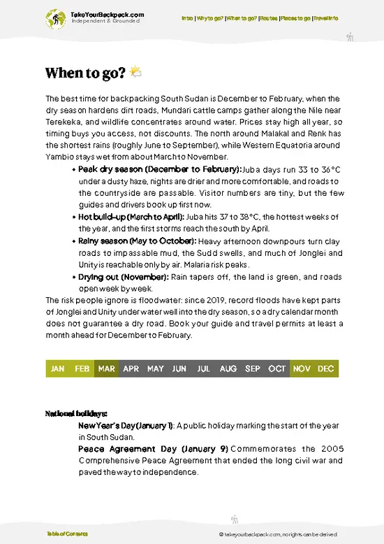
🌤️ When to go?When to go for the best experience


  • Weather: The Dongotona Mountains demand respect during the rainy season, roughly May to October. Trails turn slick, rivers swell, and the risk of landslides spikes. Dry months from November to April offer firm ground and clearer skies, making every step count without slipping.

  • Temperature: Daytime highs in the dry season hover around 28-32°C (82-90°F), perfect for pushing your limits without overheating. Nights drop to a cool 15-18°C (59-64°F), ideal for camping under stars without shivering or sweating.

  • Daylight Hours: South Sudan’s equatorial position means consistent daylight year-round—about 11 to 12 hours daily. This steady rhythm lets you plan long treks without racing the sun, but start early to avoid afternoon heat spikes.

  • Crowds: The Dongotona Mountains remain off most tourist
read more 👉

  • Weather: The Dongotona Mountains demand respect during the rainy season, roughly May to October. Trails turn slick, rivers swell, and the risk of landslides spikes. Dry months from November to April offer firm ground and clearer skies, making every step count without slipping.

  • Temperature: Daytime highs in the dry season hover around 28-32°C (82-90°F), perfect for pushing your limits without overheating. Nights drop to a cool 15-18°C (59-64°F), ideal for camping under stars without shivering or sweating.

  • Daylight Hours: South Sudan’s equatorial position means consistent daylight year-round—about 11 to 12 hours daily. This steady rhythm lets you plan long treks without racing the sun, but start early to avoid afternoon heat spikes.

  • Crowds: The Dongotona Mountains remain off most tourist radars. Dry season sees a handful of local hikers and occasional researchers, so expect solitude rather than company. Peak isolation means you own the trails and the silence.

  • Seasonal Activities: Dry months align with local festivals and market days in nearby villages, adding cultural spice to your trek. Rainy season shuts down most outdoor activities, turning the region quiet and inaccessible.

  • Price Fluctuations: Expect better deals on guides and lodging during the shoulder months (November and April) when the weather is stable but demand is low. Peak dry season can push prices up slightly, but the trade-off is trail reliability and safety.


Pro-tip: Aim for late November to early March—dry trails, manageable temps, and a chance to sync your hike with local life without the hassle of crowds or mud.


source: climatestotravel.comJANJanuary: excellent for travelingFEBFebruary: excellent for travelingMARMarch: excellent for travelingAPRApril: highly recommended for travelingMAYMay: fair for travelingJUNJune: fair for travelingJULJuly: below average for travelingAUGAugust: below average for travelingSEPSeptember: fair for travelingOCTOctober: fair for travelingNOVNovember: highly recommended for travelingDECDecember: excellent for traveling
when-to-go

✈️ The backpacker research shortcutSouth Sudan Travel Guide

An offline-friendly backpacking guide with optimized travel routes, ranked highlights, transport advice, and the best areas to stay.
example page 0 from our offline Travel Guide for South Sudan
example page 1 from our offline Travel Guide for South Sudan
example page 2 from our offline Travel Guide for South Sudan
example page 3 from our offline Travel Guide for South Sudan
example page 4 from our offline Travel Guide for South Sudan
example page 5 from our offline Travel Guide for South Sudan
example page 6 from our offline Travel Guide for South Sudan
example page 7 from our offline Travel Guide for South Sudan
The digital guide (270 pages) contains:
68 highlights, ranked by travel appeal
Optimized 5, 10 & 15-day travel routes
Cities, national parks, landmarks, beaches
How to get around
Offline-friendly for travel without Wi-Fi
👉 Click to see all 30+ guide features

📅 Plan smarter in minutes, not weeks
Month by month travel advice
Festivals & national holidays
Budget expectations

🗺️ Go to the right places, skip the overrated ones
Honest pros & cons of destinations
Top hikes, parks & viewpoints
Lesser-known places most travelers miss
Clear “worth it vs skip it” guidance

🛏️ Travel smoothly without rookie mistakes
Best areas to stay
Transport systems explained simply
Common scams & safety advice
SIM cards, money & practical tips

🌍 Understand the country, not just visit it
Culture & traditions
52 Essential phrases & customs
Festivals worth planning around
Traveler-friendly historical context
Insights that make places more meaningful

📱 Built for real travel conditions
Fully downloadable PDF
Works completely offline
Optimized for phone use
Useful in remote areas & buses
Everything in one place
Save weeks of stressful planning
Get instant access to your full guide. 30‑day money-back guarantee.
+ Add another guide for just US$7.80

By proceeding you agree to our terms.
Sent to your inbox immediately after payment • 100% Secure Checkout
Best Backpacking Travel Advisor 2025 tourism awardBest Backpacking
Travel Advisor
2025
What others say about Take Your Backpack Guides:
⭐⭐⭐⭐⭐
Fantastic, amazing amount of information!
⭐⭐⭐⭐⭐
My goodness this is amazing, it's what I've been looking for hats off too you!
⭐⭐⭐⭐⭐
I think this is absolutely BRILLIANT
⭐⭐⭐⭐
Very complete and informative. It's still missing places, but I gotta to commend you
⭐⭐⭐⭐⭐
This is truly amazing, thank you, can't wait to explore it with my kids!
⭐⭐⭐⭐⭐
Awesome resource, thank you!
⭐⭐⭐⭐⭐
This is amazing! Can't wait to explore the ones I haven't seen
⭐⭐⭐⭐
I love this! Well done, great idea.
⭐⭐⭐⭐⭐
Thanks for taking the time to make this gem!
⭐⭐⭐⭐⭐
This might be the best website I've ever seen.
⭐⭐⭐⭐⭐
Congratulations, and thank you so much for your work; it's incredibly valuable.
⭐⭐⭐⭐
In all seriousness I think you did a great job pointing out the important spots
⭐⭐⭐⭐⭐
10/10 very good
⭐⭐⭐⭐⭐
As someone who's only just starting to visit regularly this is awesome, thank you.
⭐⭐⭐⭐
Thank you very much! I'm going to visit my dad, it's going to be very useful!
⭐⭐⭐⭐⭐
This is really cool! We'll be travelling for the first time and this definitely come in handy.
⭐⭐⭐⭐⭐
You are now our minister of culture, congratulations 👨‍💼
⭐⭐⭐⭐⭐
Just wanted to tell you that this is a pearl! Going to follow your recommendations.
⭐⭐⭐⭐⭐
This is so cool. I'll definitely be using the resource for my travels soon.
⭐⭐⭐⭐⭐
This is very impressive! Good work.
⭐⭐⭐⭐⭐
This is an amazing and informative site. Very well done!

🛏️ Where to stay?Choosing the right base

If you enjoy meeting fellow travelers, consider choosing hostels with high ratings for atmosphere. On the other hand, if you prefer having your own space, a hotel might be a better option.

🥾 Hike detailsTrail overview: what to expect on the hike

Total Distance: The Dongotona Mountains trail stretches about 15 kilometers (roughly 9 miles) one way, making for a solid round trip if you’re up for it.

Estimated Duration: Expect to spend around 6 to 8 hours on the trail, depending on your pace and how often you stop to take in the views or snap some photos.

Difficulty Level: This trail is considered moderate to challenging. You’ll encounter some steep sections and rocky terrain, so a decent level of fitness is recommended.

Starting Point: The trailhead is accessible from the town of Yei. To get there by public transport, catch a minibus … read more 👉
Total Distance: The Dongotona Mountains trail stretches about 15 kilometers (roughly 9 miles) one way, making for a solid round trip if you’re up for it.

Estimated Duration: Expect to spend around 6 to 8 hours on the trail, depending on your pace and how often you stop to take in the views or snap some photos.

Difficulty Level: This trail is considered moderate to challenging. You’ll encounter some steep sections and rocky terrain, so a decent level of fitness is recommended.

Starting Point: The trailhead is accessible from the town of Yei. To get there by public transport, catch a minibus or shared taxi from Juba to Yei. The ride takes about 2 to 3 hours. Once in Yei, you can hire a local guide or find directions to the trailhead, as signage might be limited.

Major Landmarks Along the Route:
  • First Peak: A stunning viewpoint that offers panoramic vistas of the surrounding landscape.
  • Waterfall: A small but picturesque waterfall about halfway through the hike, perfect for a break.
  • Local Villages: You’ll pass by a few villages where you can interact with locals and get a taste of daily life.

Type of Terrain and Scenery: The trail features a mix of rocky paths, dirt trails, and some steep inclines. The scenery is breathtaking, with rolling hills, dense forests, and occasional clearings that reveal expansive views of the surrounding countryside.

Typical Vegetation and Wildlife:
  • Vegetation: Expect to see a variety of trees, shrubs, and grasses, with some areas thickly forested.
  • Wildlife: Keep an eye out for birds, small mammals, and maybe even some monkeys. The area is rich in biodiversity, so you might spot something interesting if you’re lucky.

Overall, the Dongotona Mountains trail offers a unique experience for independent hikers looking to explore South Sudan’s natural beauty. Just remember to pack plenty of water and snacks, and maybe a little patience for the occasional detour!
⚠️ Hiking info can sometimes be outdated or inaccurate. Before you hit the trail, check the latest conditions with locals. If you do spot anything that's off, I'd love to hear from you, so I can update it for fellow travelers.

🛡️ SafetySafety Tips and Common Scams in Dongotona Mountains

The Dongotona Mountains offer a thrilling challenge, but preparation is key. Weather can shift quickly; sunny skies can turn to rain in a heartbeat. Dress in layers and pack a reliable rain jacket. The trails are rugged, with steep ascents that will test your legs and lungs. Navigation can be tricky, so a good map and compass are essential—don’t rely solely on your phone.

Wildlife is part of the experience. You might spot monkeys or various birds, but keep your distance. Respect their space; they’re not here for selfies.

Footing can be uneven, especially after rain, so sturdy hiking boots are a must. Timing your hike is crucial; early mornings are cooler and less humid.

Stay hydrated and pace yourself. The views from the top are worth every drop of sweat. When you finally reach that summit, … read more 👉
The Dongotona Mountains offer a thrilling challenge, but preparation is key. Weather can shift quickly; sunny skies can turn to rain in a heartbeat. Dress in layers and pack a reliable rain jacket. The trails are rugged, with steep ascents that will test your legs and lungs. Navigation can be tricky, so a good map and compass are essential—don’t rely solely on your phone.

Wildlife is part of the experience. You might spot monkeys or various birds, but keep your distance. Respect their space; they’re not here for selfies.

Footing can be uneven, especially after rain, so sturdy hiking boots are a must. Timing your hike is crucial; early mornings are cooler and less humid.

Stay hydrated and pace yourself. The views from the top are worth every drop of sweat. When you finally reach that summit, take a moment to breathe it all in—this is why you came.

FAQTraveler FAQ

The Dongotona Mountains hike typically takes 2 to 3 days to complete, covering around 30 to 40 kilometers depending on the chosen route. The terrain includes steep ascents and descents, so plan accordingly for a multi-day trek.
The hike is considered moderately difficult due to rugged terrain, variable weather, and limited established trails. Hikers should be in good physical condition and prepared for uneven paths and potential altitude changes up to 1,200 meters.
Yes, you need a local guide and a permit to hike in the Dongotona Mountains. Permits are usually arranged through local authorities or tour operators, and guides are mandatory for safety and navigation in this remote area.
⚠️ Things can change over time, so always validate details locally before you go.

Other South Sudanese hikes near Dongotona Mountains

Explore more nearby:


💡 Not sure where to go next?
Create a personalized itinerary for South Sudan including Dongotona Mountains and the places that fit your trip.

Generate my itinerary

👉 Discover all hikes

Or checkout all South Sudan has to offer (think cities, towns, villages, national parks, hikes, beaches, festivals)
Country photo of South Sudan

We 💚 feedbackFinal thoughts on hiking the Dongotona Mountains

The Dongotona Mountains pulse with raw energy. You’ll feel the grit under your boots as you tackle those steep trails. The surprise? The locals are genuinely welcoming, eager to share stories over a fire. But don’t underestimate the sun; it’s relentless. Pack plenty of water and sunscreen. When you finally reach that summit, the view is a breathtaking reward—vast, untouched landscapes stretching endlessly. It’s a place that demands effort but gives back tenfold. Embrace the challenge; it’s worth every drop of sweat.

✍️ Help improve this page!
The information on this page is based on in-depth research, insights shared by experienced travelers, and feedback from the local travel community in South Sudan. While every effort is made to keep the information accurate and current, conditions can change — so if you spot anything incorrect or outdated, please get in touch.


🙋‍♂️ Give feedback

👋 Meet the founderWho’s Behind Take Your Backpack?

Johan, backpacker and founder of TakeYourBackpackHi, I’m Johan (Netherlands 🇳🇱), the creator of TakeYourBackpack. Over the past decade, I’ve backpacked through 80+ countries across six continents, gaining extensive experience with independent travel, long-term trips, and overland routes.

This site is built on a combination of firsthand travel experience and carefully curated insights from other backpackers. Many guides are based on places I’ve personally visited, while others bring together tips, observations, and practical advice shared by trusted travelers I’ve met along the way.

The goal is to provide realistic, experience-driven guidance — not generic itineraries — so you can explore destinations with better context, clearer expectations, and more confidence.

Get full country guide •
Instant download • 68 highlights • Full Offline guide