×

South Sudan🇸🇸 | hikesImatong Mountainsrainforest slopes, Mount Kinyeti summit, endemic flora | things to do and best time to go

Explore Dongotona MountainsExplore Boma Plateau Trail

Backpacking in Imatong Mountains
🏆 Top pickhike ranked #1
By Johan Kruseman 🇳🇱 | Updated September 4, 2026

Forget what you’ve read about the Imatong Mountains being just another “lush escape”—the real surprise is how cold it gets at night, even this close to the Equator. You’ll find the Imatongs in South Sudan’s southeastern corner, brushing the border with Uganda, where the land heaves up into cloud-wrapped ridges and the air smells like wet earth and woodsmoke. The hike itself is a test of patience and legs: steep, muddy, and tangled with roots, with every switchback offering a new view—sometimes a sudden waterfall, sometimes a gap in the trees that throws the whole green sweep of the plains at your feet. Getting to the trailhead is its own mini-expedition; public transport is unreliable and slow, and you’ll probably end up hitching with locals or squeezing into a battered minibus. Compared to the easier, drier hills near Juba, the Imatongs demand more sweat but pay you back with true mountain solitude and the kind of sunrise that makes you forget your blisters.

Discover everything you want to know in the 📖 South Sudan Travel Guide.
Best time to go: November - February
Duration: 3 to 5 days
Distance: 10 to 20 kilometers
Total ascent: 2,200 meters
Safety warning

The current risk level for South Sudan is high. Check the advice before going.


Get your South Sudan guide
68 ranked highlights, routes & tips, works offline (270 pages)
Loading the map 🌍
CLICK TO FILTER
cities
towns
landmarks
national parks
hikes
attractions
festivals
regions
SHOW COUNTRY’S BESTSHOW ALL

✨ Why go?
Ranked #1 hike in South Sudan
What makes this hike worth hiking

The Imatong Mountains in South Sudan draw backpackers for a reason: they offer a scenery-to-effort ratio that’s hard to beat. Picture this: jagged peaks piercing the sky, lush valleys teeming with life, and the thrill of standing atop a summit that feels like your own private kingdom. The public transport access is surprisingly straightforward, with local buses and shared taxis whisking you to the trailheads without breaking the bank.

You can tailor your adventure to fit your vibe—whether you’re up for a quick day hike or a multi-day trek, the flexible distances cater to all levels. Each step on the rugged trails is a dance with nature, where the burn in your legs is met with the reward of breathtaking views.

Plus, the low cost of trekking here means you can splurge on that first cold … read more 👉
The Imatong Mountains in South Sudan draw backpackers for a reason: they offer a scenery-to-effort ratio that’s hard to beat. Picture this: jagged peaks piercing the sky, lush valleys teeming with life, and the thrill of standing atop a summit that feels like your own private kingdom. The public transport access is surprisingly straightforward, with local buses and shared taxis whisking you to the trailheads without breaking the bank.

You can tailor your adventure to fit your vibe—whether you’re up for a quick day hike or a multi-day trek, the flexible distances cater to all levels. Each step on the rugged trails is a dance with nature, where the burn in your legs is met with the reward of breathtaking views.

Plus, the low cost of trekking here means you can splurge on that first cold beer at a local spot afterward, savoring the taste of victory. The Imatong Mountains seamlessly fit into a longer backpacking route through South Sudan, making them a must-stop for those chasing both challenge and beauty. Embrace the grit, and let the mountains transform your journey.
Want to include Imatong Mountains in your South Sudan route?
Create a personalized South Sudan itinerary that includes Imatong Mountains and the places that fit your trip — based on your travel style, budget, and available time. Get your route in seconds.

Generate my trip

💡 HighlightsPlaces and moments you shouldn't skip

  1. Mount Kinyeti summit — The highest point in the range (about 3,100+ m) and the obvious goal: steep, hands-on scrambling, thin-air views over South Sudan into Uganda and Kenya, and a real sense of being on a remote East African highland rather than a tame park trail.
  2. Kinyeti River waterfalls and pools — A string of cascades and clear plunge pools cut into the mountain slopes; perfect mid-hike breaks, lush riparian vegetation and a dramatic contrast to the dry lowlands below.
  3. Afromontane cloud forest — Moss-draped trees, dense understory and weird, slow-growing highland plants you don’t see in the savanna; the microclimate feels almost temperate and supports lots of insects and specialized plants.
  4. Ridge and escarpment viewpoints — Long, exposed ridgelines that give wide, dramatic panoramas
read more 👉
  1. Mount Kinyeti summit — The highest point in the range (about 3,100+ m) and the obvious goal: steep, hands-on scrambling, thin-air views over South Sudan into Uganda and Kenya, and a real sense of being on a remote East African highland rather than a tame park trail.
  2. Kinyeti River waterfalls and pools — A string of cascades and clear plunge pools cut into the mountain slopes; perfect mid-hike breaks, lush riparian vegetation and a dramatic contrast to the dry lowlands below.
  3. Afromontane cloud forest — Moss-draped trees, dense understory and weird, slow-growing highland plants you don’t see in the savanna; the microclimate feels almost temperate and supports lots of insects and specialized plants.
  4. Ridge and escarpment viewpoints — Long, exposed ridgelines that give wide, dramatic panoramas at sunrise/sunset — layers of valleys, distant peaks and sudden drops that make the whole walk feel cinematic compared with flatter regional hikes.
  5. Lotuko villages and cultural trails — Small, friendly farming communities tucked into the hills; hiking here often includes meeting local guides, seeing traditional terraces and crafts, and the chance for an authentic homestay or village meal that turns a hike into a cultural exchange.
Spotted a mistake or missing something? Contact us.

🌤️ When to go?Seasonal considerations and timing


  • Weather: The dry season from November to February is your best bet. Trails firm up, and the relentless mud of the rainy months gives way to solid footing. Avoid April to October when heavy rains turn paths into slippery traps and visibility drops.

  • Temperature: Daytime highs hover around 25-30°C (77-86°F) during the dry season, perfect for sustained trekking without overheating. Nights can dip to 10-15°C (50-59°F), so pack layers for chilly evenings at altitude.

  • Daylight Hours: Expect roughly 11 to 12 hours of daylight year-round near the equator. This steady light window lets you plan long, uninterrupted hikes without racing the sunset.

  • Crowds: The Imatong Mountains remain off most travelers’ radars. Even in peak dry season, you’ll find solitude rather than crowds, making every step
read more 👉

  • Weather: The dry season from November to February is your best bet. Trails firm up, and the relentless mud of the rainy months gives way to solid footing. Avoid April to October when heavy rains turn paths into slippery traps and visibility drops.

  • Temperature: Daytime highs hover around 25-30°C (77-86°F) during the dry season, perfect for sustained trekking without overheating. Nights can dip to 10-15°C (50-59°F), so pack layers for chilly evenings at altitude.

  • Daylight Hours: Expect roughly 11 to 12 hours of daylight year-round near the equator. This steady light window lets you plan long, uninterrupted hikes without racing the sunset.

  • Crowds: The Imatong Mountains remain off most travelers’ radars. Even in peak dry season, you’ll find solitude rather than crowds, making every step feel like a personal conquest.

  • Seasonal Activities: Dry months align with local farming cycles, so you might catch vibrant village life and traditional ceremonies, adding cultural depth to your trek.

  • Price Fluctuations: Costs stay relatively stable year-round due to limited tourism infrastructure. However, travel logistics can get pricier and more complicated during the rainy season, so plan accordingly.


Pro-tip: Aim for late November or early December—trails are firm, temperatures are comfortable, and the local communities are gearing up for harvest celebrations, giving your hike a rich backdrop beyond the landscape.


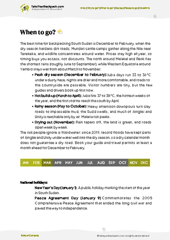
source: climatestotravel.comJANJanuary: excellent for travelingFEBFebruary: excellent for travelingMARMarch: fair for travelingAPRApril: below average for travelingMAYMay: below average for travelingJUNJune: below average for travelingJULJuly: below average for travelingAUGAugust: below average for travelingSEPSeptember: below average for travelingOCTOctober: fair for travelingNOVNovember: highly recommended for travelingDECDecember: excellent for traveling
when-to-go

✈️ The backpacker research shortcutSouth Sudan Travel Guide

An offline-friendly backpacking guide with optimized travel routes, ranked highlights, transport advice, and the best areas to stay.
example page 0 from our offline Travel Guide for South Sudan
example page 1 from our offline Travel Guide for South Sudan
example page 2 from our offline Travel Guide for South Sudan
example page 3 from our offline Travel Guide for South Sudan
example page 4 from our offline Travel Guide for South Sudan
example page 5 from our offline Travel Guide for South Sudan
example page 6 from our offline Travel Guide for South Sudan
example page 7 from our offline Travel Guide for South Sudan
The digital guide (270 pages) contains:
68 highlights, ranked by travel appeal
Optimized 5, 10 & 15-day travel routes
Cities, national parks, landmarks, beaches
How to get around
Offline-friendly for travel without Wi-Fi
👉 Click to see all 30+ guide features

📅 Plan smarter in minutes, not weeks
Month by month travel advice
Festivals & national holidays
Budget expectations

🗺️ Go to the right places, skip the overrated ones
Honest pros & cons of destinations
Top hikes, parks & viewpoints
Lesser-known places most travelers miss
Clear “worth it vs skip it” guidance

🛏️ Travel smoothly without rookie mistakes
Best areas to stay
Transport systems explained simply
Common scams & safety advice
SIM cards, money & practical tips

🌍 Understand the country, not just visit it
Culture & traditions
52 Essential phrases & customs
Festivals worth planning around
Traveler-friendly historical context
Insights that make places more meaningful

📱 Built for real travel conditions
Fully downloadable PDF
Works completely offline
Optimized for phone use
Useful in remote areas & buses
Everything in one place
Save weeks of stressful planning
Get instant access to your full guide. 30‑day money-back guarantee.
+ Add another guide for just US$7.80

By proceeding you agree to our terms.
Sent to your inbox immediately after payment • 100% Secure Checkout
Best Backpacking Travel Advisor 2025 tourism awardBest Backpacking
Travel Advisor
2025
What others say about Take Your Backpack Guides:
⭐⭐⭐⭐⭐
Fantastic, amazing amount of information!
⭐⭐⭐⭐⭐
My goodness this is amazing, it's what I've been looking for hats off too you!
⭐⭐⭐⭐⭐
I think this is absolutely BRILLIANT
⭐⭐⭐⭐
Very complete and informative. It's still missing places, but I gotta to commend you
⭐⭐⭐⭐⭐
This is truly amazing, thank you, can't wait to explore it with my kids!
⭐⭐⭐⭐⭐
Awesome resource, thank you!
⭐⭐⭐⭐⭐
This is amazing! Can't wait to explore the ones I haven't seen
⭐⭐⭐⭐
I love this! Well done, great idea.
⭐⭐⭐⭐⭐
Thanks for taking the time to make this gem!
⭐⭐⭐⭐⭐
This might be the best website I've ever seen.
⭐⭐⭐⭐⭐
Congratulations, and thank you so much for your work; it's incredibly valuable.
⭐⭐⭐⭐
In all seriousness I think you did a great job pointing out the important spots
⭐⭐⭐⭐⭐
10/10 very good
⭐⭐⭐⭐⭐
As someone who's only just starting to visit regularly this is awesome, thank you.
⭐⭐⭐⭐
Thank you very much! I'm going to visit my dad, it's going to be very useful!
⭐⭐⭐⭐⭐
This is really cool! We'll be travelling for the first time and this definitely come in handy.
⭐⭐⭐⭐⭐
You are now our minister of culture, congratulations 👨‍💼
⭐⭐⭐⭐⭐
Just wanted to tell you that this is a pearl! Going to follow your recommendations.
⭐⭐⭐⭐⭐
This is so cool. I'll definitely be using the resource for my travels soon.
⭐⭐⭐⭐⭐
This is very impressive! Good work.
⭐⭐⭐⭐⭐
This is an amazing and informative site. Very well done!

🛏️ Where to stay?Best areas to stay in South Sudan

If you enjoy meeting fellow travelers, consider choosing hostels with high ratings for atmosphere. On the other hand, if you prefer having your own space, a hotel might be a better option.

🥾 Hike detailsHike details: route, duration, and difficulty of Imatong Mountains

Total Distance: The trail through the Imatong Mountains covers approximately 40 kilometers (about 25 miles) if you take the main route, which can vary depending on detours and side paths you might explore.

Estimated Duration: Plan for around 3 to 5 days to fully enjoy the hike, allowing time for breaks, exploration, and soaking in the views. It’s not a race, so pace yourself.

Difficulty Level: This trail is generally considered moderate to challenging. You’ll encounter steep ascents, rocky paths, and some slippery sections, especially during rainy seasons. Good fitness will help, but determination … read more 👉
Total Distance: The trail through the Imatong Mountains covers approximately 40 kilometers (about 25 miles) if you take the main route, which can vary depending on detours and side paths you might explore.

Estimated Duration: Plan for around 3 to 5 days to fully enjoy the hike, allowing time for breaks, exploration, and soaking in the views. It’s not a race, so pace yourself.

Difficulty Level: This trail is generally considered moderate to challenging. You’ll encounter steep ascents, rocky paths, and some slippery sections, especially during rainy seasons. Good fitness will help, but determination counts for a lot, too.

Starting Point: The trailhead is near the town of Torit, which you can reach by public transport. From Juba, take a bus or shared taxi to Torit. The ride takes about 3 to 4 hours, depending on road conditions. Once in Torit, you can hire a local guide or join a small group to navigate the trail.

Major Landmarks Along the Route:
  • Mount Kinyeti: The highest peak in South Sudan, offering breathtaking views from the summit.
  • Lake Kinyeti: A serene spot to rest and take in the tranquil waters, perfect for a lunch break.
  • Local Villages: You’ll pass through small communities where you can experience local culture and possibly find a place to camp.

Type of Terrain and Scenery: Expect a mix of rocky paths, grassy meadows, and forested areas. The higher you go, the more stunning the vistas become, with sweeping views of valleys and distant hills. The terrain can be rugged, so sturdy boots are a must.

Typical Vegetation and Wildlife: The Imatong Mountains are home to diverse flora, including montane forests and grasslands. You might spot acacia trees, wildflowers, and various shrubs. As for wildlife, keep an eye out for birds like the African grey parrot, and if you’re lucky, you might catch a glimpse of monkeys or other small mammals. Just remember, the wildlife can be shy, so patience is key.

This trail is a gem for those looking to escape the usual tourist paths and embrace the beauty of South Sudan’s landscape. Just be sure to prepare well and respect the local customs along the way!
⚠️ Hiking info can sometimes be outdated or inaccurate. Before you hit the trail, check the latest conditions with locals. If you do spot anything that's off, I'd love to hear from you, so I can update it for fellow travelers.

🛡️ SafetyStaying Safe: What Travelers Should Know

The Imatong Mountains offer a rugged beauty that demands respect but rewards effort. Weather can shift quickly; expect sun one moment and rain the next. Dress in layers and pack a waterproof jacket. The trails are steep and rocky, so good hiking boots are essential. Navigation can be tricky; a reliable map or GPS is your best friend here.

Watch your footing on the narrow paths, especially after rain when mud can turn the trail into a slip-and-slide. River crossings are rare but can be challenging; scout for the safest spots before you leap.

Wildlife is present, but encounters are generally low-key. If you spot a baboon or a bushbuck, keep your distance and enjoy the moment without intruding.

Preparation is key. Hydration is crucial, so carry enough water and a filter for refills. Start … read more 👉
The Imatong Mountains offer a rugged beauty that demands respect but rewards effort. Weather can shift quickly; expect sun one moment and rain the next. Dress in layers and pack a waterproof jacket. The trails are steep and rocky, so good hiking boots are essential. Navigation can be tricky; a reliable map or GPS is your best friend here.

Watch your footing on the narrow paths, especially after rain when mud can turn the trail into a slip-and-slide. River crossings are rare but can be challenging; scout for the safest spots before you leap.

Wildlife is present, but encounters are generally low-key. If you spot a baboon or a bushbuck, keep your distance and enjoy the moment without intruding.

Preparation is key. Hydration is crucial, so carry enough water and a filter for refills. Start early to avoid the midday heat, and don’t rush—take time to soak in the views. The effort will pay off when you reach a summit and feel that cool breeze on your face.

FAQFrequently asked questions about Imatong Mountains

The Imatong Mountains hike typically takes 3 to 5 days depending on the route and pace. The main trek to Mount Kinyeti, the highest peak, covers about 40 kilometers round trip. Plan for full days of hiking with overnight camping.
The hike is moderately difficult due to steep ascents, uneven terrain, and variable weather conditions. Elevation gain can reach over 2,000 meters, requiring good fitness and hiking experience. Trails are not well-marked, adding to the challenge.
Yes, a guide is strongly recommended for safety and navigation, as the area is remote and local knowledge is essential. A permit is required from South Sudanese authorities, usually arranged through local tour operators or government offices, with fees varying but generally around $50.
⚠️ Things can change over time, so always validate details locally before you go.

Other South Sudanese hikes near Imatong Mountains

Explore more nearby:


💡 Not sure where to go next?
Create a personalized itinerary for South Sudan including Imatong Mountains and the places that fit your trip.

Generate my itinerary

👉 Discover all hikes

Or checkout all South Sudan has to offer (think cities, towns, villages, national parks, hikes, beaches, festivals)
Country photo of South Sudan

We 💚 feedbackIs it worth it?

The Imatong Mountains are raw and rugged, a real test of grit. The trails can be steep and unforgiving, but when you reach the summit, the view opens up like a secret you’ve earned. Expect to sweat and maybe curse a little, but that first cold beer at the village afterward? Pure bliss. Just be ready for the locals; their warmth is genuine, but their curiosity can be overwhelming. Embrace it. This place isn’t polished, but that’s what makes it unforgettable.

✍️ Help improve this page!
The information on this page is based on in-depth research, insights shared by experienced travelers, and feedback from the local travel community in South Sudan. While every effort is made to keep the information accurate and current, conditions can change — so if you spot anything incorrect or outdated, please get in touch.


🙋‍♂️ Give feedback

👋 Meet the founderWho’s Behind Take Your Backpack?

Johan, backpacker and founder of TakeYourBackpackHi, I’m Johan (Netherlands 🇳🇱), the creator of TakeYourBackpack. Over the past decade, I’ve backpacked through 80+ countries across six continents, gaining extensive experience with independent travel, long-term trips, and overland routes.

This site is built on a combination of firsthand travel experience and carefully curated insights from other backpackers. Many guides are based on places I’ve personally visited, while others bring together tips, observations, and practical advice shared by trusted travelers I’ve met along the way.

The goal is to provide realistic, experience-driven guidance — not generic itineraries — so you can explore destinations with better context, clearer expectations, and more confidence.

Get full country guide •
Instant download • 68 highlights • Full Offline guide