


- Matafao Peak Summit: The island’s highest point, at about 653 meters (2,142 feet), and the reason for the trek. On a clear morning the view runs down to the harbor and out to open ocean on both coasts. When cloud rolls in, the top becomes a damp, green, quiet clearing, so go early.
- Fagasa Pass Trailhead: The road crossing where the climb begins, with the first glimpses of the north coast and the harbor behind you. Expect a steady uphill start through plantation edges before the forest closes in.
- The Ridge Climb: The middle stretch is the hard part, steep and often slick, with roots and clay doing the work of steps. Allow roughly 4 to 6 hours round trip, and carry more water than seems sensible.
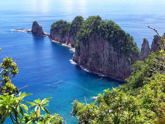
- Pago Pago Harbor from Above: One of the best ways to understand why this inlet is so deep and sheltered.
- Matafao Peak Summit: The island’s highest point, at about 653 meters (2,142 feet), and the reason for the trek. On a clear morning the view runs down to the harbor and out to open ocean on both coasts. When cloud rolls in, the top becomes a damp, green, quiet clearing, so go early.
- Fagasa Pass Trailhead: The road crossing where the climb begins, with the first glimpses of the north coast and the harbor behind you. Expect a steady uphill start through plantation edges before the forest closes in.
- The Ridge Climb: The middle stretch is the hard part, steep and often slick, with roots and clay doing the work of steps. Allow roughly 4 to 6 hours round trip, and carry more water than seems sensible.
- Pago Pago Harbor from Above: One of the best ways to understand why this inlet is so deep and sheltered. The harbor is the drowned crater of an old volcano, and from up here the shape makes sense in a way it never does from the road.
- Rainmaker Mountain (Mount Pioa): Seen from the heights across the water, this blunt peak catches the clouds and explains its nickname. It is a good landmark for working out where you are and which way the weather is heading.
- Upland Rainforest: The climb passes through damp, dense native forest with tree ferns, vines and bird calls. Flying foxes, the large fruit bats of the islands, are most often seen gliding over the canopy toward evening.
- Fagasa Bay Views: Looking north from the ridge, the cliffs and the small bay below Fagasa village show the wilder, less visited side of Tutuila, a sharp contrast with the busy harbor to the south.
Spotted a mistake or missing something? Contact us.

 Best Backpacking
 Hi, I’m Johan (Netherlands 🇳🇱), the creator of TakeYourBackpack. Over the past 3 decades, I’ve backpacked through 90+ countries across six continents, gaining extensive experience with independent travel, long-term trips, and overland routes.