×

Réunion🇷🇪 | landmarksLa Roche Écrite2,277 m summit, Mare Longue trailhead, tamarind roots, Mafate overlook | things to do and best time to go

Explore La Cascade du Voile de la MariéeExplore La Roche Merveilleuse

Backpacking in La Roche Écrite
👍 Recommendedunique site ranked #5
By Johan Kruseman 🇳🇱 | Updated October 22, 2026

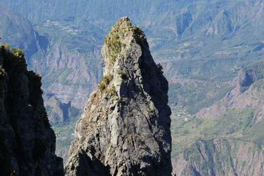
The summit of La Roche Écrite, at 2,277 meters, is the highest point you can reach on Réunion without a guide or special gear, and the trail starts from a road end at Mare Longue, not from a town. The mountain stands above the Plaine des Palmistes and Saint-Denis, in the north of Réunion. The path climbs through damp tamarind forest, with roots like stairs, then breaks into open heath where the wind smells of wet moss and tree heather. Expect mud, cold fingers and cloud that can swallow the view at 8 a.m. Clear mornings give you the cirque of Mafate laid out below, sharp ridges and tiny orange roofs, which is worth every slippery step. Fit hikers who like early starts will love it. Anyone wanting a sure view or a gentle stroll won't.

Discover everything you want to know in the 📖 Réunion Travel Guide.


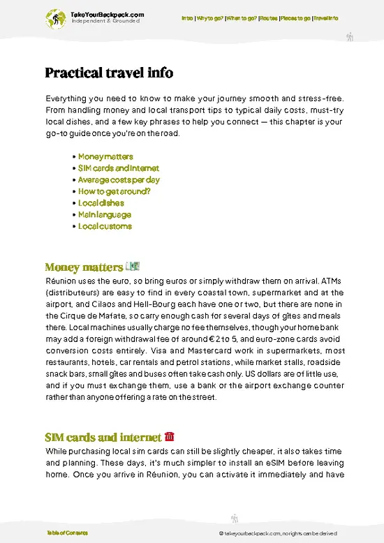
example page 0 from our offline Travel Guide for Réunion
example page 1 from our offline Travel Guide for Réunion
example page 2 from our offline Travel Guide for Réunion
example page 3 from our offline Travel Guide for Réunion
example page 4 from our offline Travel Guide for Réunion
example page 5 from our offline Travel Guide for Réunion
example page 6 from our offline Travel Guide for Réunion
example page 7 from our offline Travel Guide for Réunion
Loading the map 🌍
CLICK TO FILTER
cities
towns
villages
landmarks
national parks
hikes
beaches
attractions
festivals
SHOW COUNTRY’S BESTSHOW ALL

✨ Why go?
Ranked #5 unique site in Réunion
Why La Roche Écrite should be on your travel list

La Roche Écrite gives you a Mafate panorama for the price of a half-day hike, with no hut booking, no guide and no multi-day commitment. That is rare on an island where the biggest views usually demand a long haul. The trail is steep but well marked, and the effort is clear: roughly 3 to 4 hours up and a similar time down from the trailhead at Col du Boeuf, with about 600 meters of climb. The summit also carries the lore of the Tamarins, the cliff-hugging heath of Réunion's highlands, and the endemic birds that live there, including the Tec-Tec, a small bird you may hear before you see. It also fits a wider route easily. Combine it with the Plaine des Palmistes, the Bélouve forest and Saint-Denis, or follow it with Mafate cirque hiking, since the summit gives you a preview of those valleys and ridges before you commit to them.

💡 HighlightsDon't-miss highlights and experiences

  1. The summit viewpoint: the 2,277-meter top looks straight down into Mafate, with Le Grand Bénare and the Piton des Neiges ridge lined up behind on clear mornings.
  2. Mare Longue and Col du Boeuf trailhead: the start of the climb, a quiet forest road end where the air turns cool and smells of damp earth.
  3. Tamarind forest section: tall, flat-topped tamarinds with moss-covered trunks and roots that form natural steps in the early part of the trail.
  4. Heath and tree heather plateau: the open upper slopes where wind-bent shrubs, lichens and low cloud make the landscape feel like the Scottish highlands.
  5. Tec-Tec and endemic birdlife: the Réunion stonechat is common on the heath, and its ticking call is the soundtrack of the upper trail.
  6. Mafate cirque overlook: the ridge edge where the drop opens up, with the
… read more 👉
  1. The summit viewpoint: the 2,277-meter top looks straight down into Mafate, with Le Grand Bénare and the Piton des Neiges ridge lined up behind on clear mornings.
  2. Mare Longue and Col du Boeuf trailhead: the start of the climb, a quiet forest road end where the air turns cool and smells of damp earth.
  3. Tamarind forest section: tall, flat-topped tamarinds with moss-covered trunks and roots that form natural steps in the early part of the trail.
  4. Heath and tree heather plateau: the open upper slopes where wind-bent shrubs, lichens and low cloud make the landscape feel like the Scottish highlands.
  5. Tec-Tec and endemic birdlife: the Réunion stonechat is common on the heath, and its ticking call is the soundtrack of the upper trail.
  6. Mafate cirque overlook: the ridge edge where the drop opens up, with the isolated hamlet of Roche Plate visible far below.
  7. Plaine des Palmistes views: on the descent, glimpses toward the highland plain and its farms and forest give a sense of how high you have climbed.
Every item here is free, since the trail and its views cost nothing to enter.
Spotted a mistake or missing something? Contact us.

🌤️ When to go?Seasonal considerations and timing

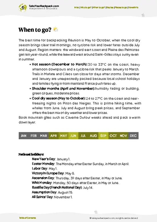
  • Austral winter (May to October): Clear, dry mornings make this the safest window for the summit. Days run 18 to 24°C (64 to 75°F) at the trailhead, but the 2,277 m (7,470 ft) top can drop to 2 to 8°C (36 to 46°F) at dawn. Daylight lasts roughly 11 to 12 hours, so start early. Weekends fill the Mare Longue parking area, and the Plaine des Palmistes gîtes book up in July and August school holidays.
  • Summer (November to April): Hot, humid, and wetter, with 25 to 30°C (77 to 86°F) in the lowlands and cloud rolling in by late morning. Cyclones can close the trail, mainly January to March. Trails get slick, but crowds thin and lodging costs drop.
  • Shoulder weeks (April, May, November): Mild temperatures and fewer hikers.
Leave the trailhead before 7 am, because the view over the Cirque de Mafate is usually gone behind cloud by midday.

source: climatestotravel.comJANJanuary: fair for travelingFEBFebruary: fair for travelingMARMarch: fair for travelingAPRApril: fair for travelingMAYMay: highly recommended for travelingJUNJune: excellent for travelingJULJuly: excellent for travelingAUGAugust: excellent for travelingSEPSeptember: excellent for travelingOCTOctober: highly recommended for travelingNOVNovember: highly recommended for travelingDECDecember: fair for traveling
reunion-unique-site-la-roche-ecrite v1
© Google |

✈️ The backpacker research shortcutRéunion Travel Guide

An offline-friendly backpacking guide with optimized travel routes, ranked highlights, transport advice, and the best areas to stay.
example page 0 from our offline Travel Guide for Réunion
example page 1 from our offline Travel Guide for Réunion
example page 2 from our offline Travel Guide for Réunion
example page 3 from our offline Travel Guide for Réunion
example page 4 from our offline Travel Guide for Réunion
example page 5 from our offline Travel Guide for Réunion
example page 6 from our offline Travel Guide for Réunion
example page 7 from our offline Travel Guide for Réunion
The digital guide (232 pages) contains:
✅ 64 highlights, ranked by travel appeal
✅ Optimized 2, 3 & 5-day travel routes
✅ Cities, national parks, landmarks, beaches
✅ How to get around
✅ Offline-friendly for travel without Wi-Fi
👉 Click to see all 30+ guide features

📅 Plan smarter in minutes, not weeks
✅ Month by month travel advice
✅ Festivals & national holidays
✅ Budget expectations

🗺️ Go to the right places, skip the overrated ones
✅ Honest pros & cons of destinations
✅ Top hikes, parks & viewpoints
✅ Lesser-known places most travelers miss
✅ Clear “worth it vs skip it” guidance

🛏️ Travel smoothly without rookie mistakes
✅ Best areas to stay
✅ Transport systems explained simply
✅ Common scams & safety advice
✅ SIM cards, money & practical tips

🌍 Understand the country, not just visit it
✅ Culture & traditions
✅ 52 Essential phrases & customs
✅ Festivals worth planning around
✅ Traveler-friendly historical context
✅ Insights that make places more meaningful

📱 Built for real travel conditions
✅ Fully downloadable PDF
✅ Works completely offline
✅ Optimized for phone use
✅ Useful in remote areas & buses
✅ Everything in one place
Stop searching, start planning
Get instant access to your full guide. 30‑day money-back guarantee.
+ Add another guide for just

By proceeding you agree to our terms.
Sent to your inbox immediately after payment • 100% Secure Checkout
Best Backpacking Travel Advisor 2025 tourism awardBest Backpacking
Travel Advisor
2025
What others say about Take Your Backpack Guides:
⭐⭐⭐⭐⭐
Fantastic, amazing amount of information!
⭐⭐⭐⭐⭐
My goodness this is amazing, it's what I've been looking for hats off too you!
⭐⭐⭐⭐⭐
I think this is absolutely BRILLIANT
⭐⭐⭐⭐
Very complete and informative. It's still missing places, but I gotta to commend you
⭐⭐⭐⭐⭐
This is truly amazing, thank you, can't wait to explore it with my kids!
⭐⭐⭐⭐⭐
Awesome resource, thank you!
⭐⭐⭐⭐⭐
This is amazing! Can't wait to explore the ones I haven't seen
⭐⭐⭐⭐
I love this! Well done, great idea.
⭐⭐⭐⭐⭐
Thanks for taking the time to make this gem!
⭐⭐⭐⭐⭐
This might be the best website I've ever seen.
⭐⭐⭐⭐⭐
Congratulations, and thank you so much for your work; it's incredibly valuable.
⭐⭐⭐⭐
In all seriousness I think you did a great job pointing out the important spots
⭐⭐⭐⭐⭐
10/10 very good
⭐⭐⭐⭐⭐
As someone who's only just starting to visit regularly this is awesome, thank you.
⭐⭐⭐⭐
Thank you very much! I'm going to visit my dad, it's going to be very useful!
⭐⭐⭐⭐⭐
This is really cool! We'll be travelling for the first time and this definitely come in handy.
⭐⭐⭐⭐⭐
You are now our minister of culture, congratulations 👨‍💼
⭐⭐⭐⭐⭐
Just wanted to tell you that this is a pearl! Going to follow your recommendations.
⭐⭐⭐⭐⭐
This is so cool. I'll definitely be using the resource for my travels soon.
⭐⭐⭐⭐⭐
This is very impressive! Good work.
⭐⭐⭐⭐⭐
This is an amazing and informative site. Very well done!

🛏️ Where to stay?Choosing the right base

Plaine des Palmistes is the smartest base, since the trailhead sits a short drive up the forest road from the village. It is a quiet highland town with a bakery, a supermarket, and a handful of gîtes and guesthouses, so you sleep at about 1,000 m (3,300 ft) and wake cool and rested. It is safe, walkable, and full of hikers, which makes sharing a rental car or a lift to the trailhead easy. Expect early nights and little nightlife.
Saint-Denis suits those who want hostels, cheap eats, and a social scene. Rooms there are more affordable, and you can meet other trekkers in the center, but you face … read more 👉
Plaine des Palmistes is the smartest base, since the trailhead sits a short drive up the forest road from the village. It is a quiet highland town with a bakery, a supermarket, and a handful of gîtes and guesthouses, so you sleep at about 1,000 m (3,300 ft) and wake cool and rested. It is safe, walkable, and full of hikers, which makes sharing a rental car or a lift to the trailhead easy. Expect early nights and little nightlife.
Saint-Denis suits those who want hostels, cheap eats, and a social scene. Rooms there are more affordable, and you can meet other trekkers in the center, but you face a drive of about an hour each way on winding roads to reach the start.
Saint-Benoît on the east coast is a lower, warmer option with guesthouses and market stalls, and it works if you pair the hike with the Rivière des Marsouins area. Bring your own transport, because buses are sparse and slow. For a hiker-only crowd, the gîtes of Bras-Panon and Plaine des Palmistes offer shared dinners where trail talk flows freely.

👛 Costs (as of 22 October 2026)Money, prices, and spending tips

A day on La Roche Écrite costs about €62 for a backpacker, and the hike itself is free. Your main expenses are getting to the trailhead and a bed in a highland village. Payments are in euros.
CategoryBudget RangeLocal Reality
Trail access€0No permit or ticket is needed for the marked path.
Accommodation (high season)€25 to 40Dorm beds and simple gîte rooms; in July and August they sell out early. Low season runs €20 to 32.
Transport€10 to 25Buses reach Plaine des Palmistes, but the trailhead needs a taxi or rental car. Fuel and parking are small costs.
Food€15 to 25Bakery sandwiches, supermarket supplies, and a creole plate of rice, lentils, and sausage at a local table.
Gear and extras€0 to 8Pack a warm layer, rain jacket, and 2 liters of water. Hot drinks at the village cost €2 to 3.
Total Daily
… read more 👉
A day on La Roche Écrite costs about €62 for a backpacker, and the hike itself is free. Your main expenses are getting to the trailhead and a bed in a highland village. Payments are in euros.
CategoryBudget RangeLocal Reality
Trail access€0No permit or ticket is needed for the marked path.
Accommodation (high season)€25 to 40Dorm beds and simple gîte rooms; in July and August they sell out early. Low season runs €20 to 32.
Transport€10 to 25Buses reach Plaine des Palmistes, but the trailhead needs a taxi or rental car. Fuel and parking are small costs.
Food€15 to 25Bakery sandwiches, supermarket supplies, and a creole plate of rice, lentils, and sausage at a local table.
Gear and extras€0 to 8Pack a warm layer, rain jacket, and 2 liters of water. Hot drinks at the village cost €2 to 3.
Total Daily Budget€50 to 98Roughly €62 is a realistic day with a shared ride.


source: reunion.fr
⚠️ Prices can change and everyone travels differently, so take this as a rough guide. Hope it helps you plan your adventure!

FAQTraveler FAQ

La Roche Écrite is a 2,277 m (7,470 ft) summit in the Réunion National Park, overlooking the Cirque de Mafate and the Cirque de Salazie. It is the island’s most popular day hike after the volcano. The trail climbs through tamarind forest and open heath, where you may spot the endemic Réunion marsh harrier or the tuit-tuit.
Plan on a full day, roughly 5 to 7 hours for the round trip from the trailhead at Mare Longue. The climb is about 4 km (2.5 mi) each way with roughly 900 m (2,950 ft) of ascent. Start by 7 am to reach the summit before clouds fill in, and allow extra time if you want to linger at the viewpoint.
La Roche Écrite is reached by road from Plaine des Palmistes, about 45 minutes to 1 hour from Saint-Denis or Saint-Benoît by car. Public buses reach Plaine des Palmistes, but the last stretch of forest road to the Mare Longue trailhead needs a rental car or taxi, costing roughly €20 to 40. Parking at the trailhead is free but fills early on weekends.
⚠️ Things can change over time, so always validate details locally before you go.

Other Réunionnais landmarks near La Roche Écrite

Explore more nearby:


💡 Not sure where to go next?
Create a personalized itinerary for Réunion including La Roche Écrite and the places that fit your trip.

Generate my itinerary

👉 Discover all landmarks

Or checkout all Réunion has to offer (think cities, towns, villages, national parks, hikes, beaches, festivals)
Country photo of Réunion

We 💚 feedbackFinal thoughts on visiting La Roche Écrite

La Roche Écrite punishes travelers who start at midday, because cloud usually rolls in by late morning and hides the one thing you climbed for. Begin at first light, carry a rain layer and warm gloves, and treat any clear view as a bonus rather than a promise.

✍️ Help improve this page!
The information on this page is based on in-depth research, insights shared by experienced travelers, and feedback from the local travel community in Réunion. While every effort is made to keep the information accurate and current, conditions can change — so if you spot anything incorrect or outdated, please get in touch.


🙋‍♂️ Give feedback

👋 Meet the founderWho’s Behind Take Your Backpack?

Johan, backpacker and founder of TakeYourBackpackHi, I’m Johan (Netherlands 🇳🇱), the creator of TakeYourBackpack. Over the past 3 decades, I’ve backpacked through 90+ countries across six continents, gaining extensive experience with independent travel, long-term trips, and overland routes.

This site is built on a combination of firsthand travel experience and carefully curated insights from other backpackers. Many guides are based on places I’ve personally visited, while others bring together tips, observations, and practical advice shared by trusted travelers I’ve met along the way.

The goal is to provide realistic, experience-driven guidance — not generic itineraries — so you can explore destinations with better context, clearer expectations, and more confidence.