
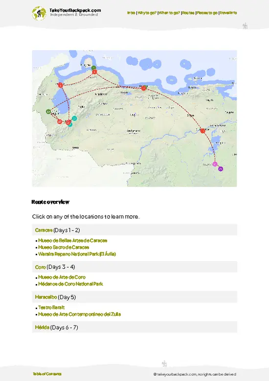
- Upper Tocuyo river basin: the park’s reason for existing, with streams that start in mossy forest and feed the valleys below.
- Cloud forest belt: trees draped in moss, bromeliads and orchids, dripping and cold, with tree ferns along the shaded trails.
- High ridgelines above 3,000 m: open, windy ground where the forest thins and the views run across several Andean ranges.
- Chabasquén approach: the Portuguesa side, where farm tracks climb past small plots and give a first look at the park’s edge.
- El Tocuyo gateway: a colonial town, one of the oldest in Venezuela, handy for supplies before heading uphill.
- Birdlife of the forest: mixed flocks of tanagers and hummingbirds work the mid-elevation trees, best heard at dawn.
- Coffee-farm foothills: shaded plantations around 1,200 m where the walk begins among
- Upper Tocuyo river basin: the park’s reason for existing, with streams that start in mossy forest and feed the valleys below.
- Cloud forest belt: trees draped in moss, bromeliads and orchids, dripping and cold, with tree ferns along the shaded trails.
- High ridgelines above 3,000 m: open, windy ground where the forest thins and the views run across several Andean ranges.
- Chabasquén approach: the Portuguesa side, where farm tracks climb past small plots and give a first look at the park’s edge.
- El Tocuyo gateway: a colonial town, one of the oldest in Venezuela, handy for supplies before heading uphill.
- Birdlife of the forest: mixed flocks of tanagers and hummingbirds work the mid-elevation trees, best heard at dawn.
- Coffee-farm foothills: shaded plantations around 1,200 m where the walk begins among drying beans and banana trees.
Spotted a mistake or missing something? Contact us.

 Best Backpacking
 Hi, I’m Johan (Netherlands 🇳🇱), the creator of TakeYourBackpack. Over the past 3 decades, I’ve backpacked through 90+ countries across six continents, gaining extensive experience with independent travel, long-term trips, and overland routes.