×

Indonesia🇮🇩 | hikesMount Rinjanihigh-altitude crater lake, steep ascent, hot springs | things to do and best time to go

Explore Mount BromoExplore Gunung Agung

Backpacking in Mount Rinjani
🏆 Top pickhike ranked #1
By Johan Kruseman 🇳🇱 | Updated October 15, 2026

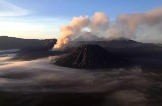
Volcanic grit crunches under your boots at 3 a.m. while a line of headlamps zigzags above you, and every second step slides half a step back. That is the summit push on Mount Rinjani, the 3,726 meter volcano on the northern half of Lombok island in West Nusa Tenggara, Indonesia. The trek runs 2 to 4 days, with 2D1N (the crater rim and back) the most common. It is steep, dusty and physically demanding, but you get a turquoise crater lake, hot springs and a sunrise above the clouds. The cons are real: crowds on the rim, trash on the lower slopes and a punishing final ascent. Getting to the start is easy. Public minibuses and ojeks run from Mataram to Senaru and Sembalun, which is simpler than reaching most Indonesian volcanoes such as Semeru. I sat on the rim at dawn with sweet black coffee burning my fingers while Gunung Agung floated on the far horizon, and every sliding step of that climb felt paid for.

Discover everything you want to know in the 📖 Indonesia Travel Guide.
Best time to go: April - October
Duration: 2 to 3 days
Distance: 26 kilometers
Total ascent: 2,600 meters


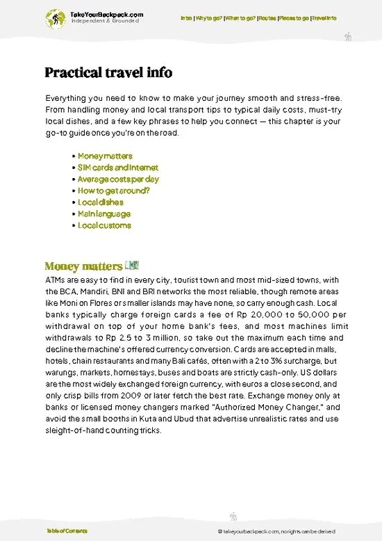
example page 0 from our offline Travel Guide for Indonesia
example page 1 from our offline Travel Guide for Indonesia
example page 2 from our offline Travel Guide for Indonesia
example page 3 from our offline Travel Guide for Indonesia
example page 4 from our offline Travel Guide for Indonesia
example page 5 from our offline Travel Guide for Indonesia
example page 6 from our offline Travel Guide for Indonesia
example page 7 from our offline Travel Guide for Indonesia
Loading the map 🌍
CLICK TO FILTER
cities
towns
villages
landmarks
national parks
hikes
beaches
attractions
festivals
regions
SHOW COUNTRY’S BESTSHOW ALL

✨ Why go?
Ranked #1 hike in Indonesia
What makes this hike worth hiking

Backpackers chase Mount Rinjani because the scenery per day of effort is hard to match in Southeast Asia. In two to three days you cross savanna, cloud forest, a crater rim, a caldera lake and steaming hot springs. Public transport reaches both trailheads: bemo and minibuses from Mataram to Senaru or Sembalun, and tourist shuttles from Senggigi and the Gili Islands. The cost is moderate. Group treks including permits, porters, food and tents typically run about US$100 to 250 depending on length and operator. Flexible distances let you choose a 2D1N rim trek, a 3D2N loop that adds the lake and hot springs, or a 4D3N trip with a slower pace. It also fits an overland route neatly: arrive from Bali by ferry, finish with beach days in the Gilis or Kuta Lombok, then move on east toward Flores and … read more 👉
Backpackers chase Mount Rinjani because the scenery per day of effort is hard to match in Southeast Asia. In two to three days you cross savanna, cloud forest, a crater rim, a caldera lake and steaming hot springs. Public transport reaches both trailheads: bemo and minibuses from Mataram to Senaru or Sembalun, and tourist shuttles from Senggigi and the Gili Islands. The cost is moderate. Group treks including permits, porters, food and tents typically run about US$100 to 250 depending on length and operator. Flexible distances let you choose a 2D1N rim trek, a 3D2N loop that adds the lake and hot springs, or a 4D3N trip with a slower pace. It also fits an overland route neatly: arrive from Bali by ferry, finish with beach days in the Gilis or Kuta Lombok, then move on east toward Flores and Komodo. Porters carry your gear, so even a first-time hiker can manage it.

💡 HighlightsTop highlights of Mount Rinjani

  1. Segara Anak Crater Lake: A deep blue caldera lake at roughly 2,000 meters, about 200 meters deep, and the visual centerpiece of the loop. Local anglers cast lines from the shore, and the water changes from teal to dark navy as clouds pass.
  2. Summit Sunrise: At 3,726 meters, the top of Indonesia’s second-highest volcano gives a sunrise view across Lombok and, on clear mornings, to Bali’s Gunung Agung and Sumbawa’s Tambora region. The climb starts around 2 to 3 a.m. across loose scree.
  3. Sembalun Crater Rim: The campsite at roughly 2,600 meters sits on a grassy ridge with views down into the caldera. Sunset here turns the lake orange and the clouds pool below your tent.
  4. Hot Springs: Sulfur-rich natural pools near the lake, fed by volcanic activity, soak tired legs after the steep descent from the rim.
… read more 👉
  1. Segara Anak Crater Lake: A deep blue caldera lake at roughly 2,000 meters, about 200 meters deep, and the visual centerpiece of the loop. Local anglers cast lines from the shore, and the water changes from teal to dark navy as clouds pass.
  2. Summit Sunrise: At 3,726 meters, the top of Indonesia’s second-highest volcano gives a sunrise view across Lombok and, on clear mornings, to Bali’s Gunung Agung and Sumbawa’s Tambora region. The climb starts around 2 to 3 a.m. across loose scree.
  3. Sembalun Crater Rim: The campsite at roughly 2,600 meters sits on a grassy ridge with views down into the caldera. Sunset here turns the lake orange and the clouds pool below your tent.
  4. Hot Springs: Sulfur-rich natural pools near the lake, fed by volcanic activity, soak tired legs after the steep descent from the rim. They are a welcome treat on a 3D2N trek.
  5. Sembalun Savanna: The first day crosses open golden grassland with the cone rising ahead, a very different landscape from the forested Senaru route. The wide views make it an easy section to photograph.
I would pick the summit sunrise first. Nothing else on Rinjani rewards you so directly for a miserable, sliding, freezing hour of pre-dawn climbing, and the light across the island is worth every step.
Spotted a mistake or missing something? Contact us.

Things to do around Mount Rinjani

Ratings based on Tripadvisor reviews. When you book through this link, you support our work at no extra cost to you.

🌤️ When to go?When to go for the best experience

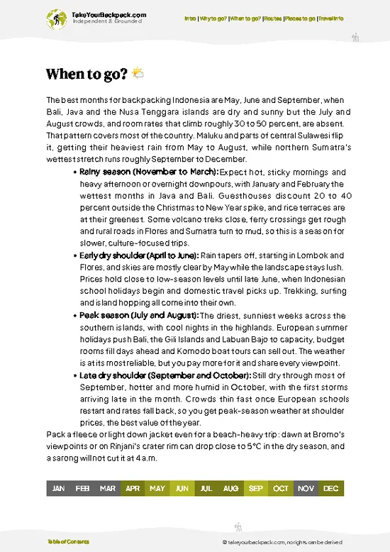
  • Dry Season (May to September): This is the best window, with clear mornings and mostly stable trails. Summit temperatures drop to roughly 0 to 5°C (32 to 41°F), while the lower slopes sit around 20 to 28°C (68 to 82°F). Daylight runs about 6 a.m. to 6 p.m.
  • Peak Crowds (July and August): Expect full campsites on the crater rim and higher prices from operators.
  • Shoulder Months (April and October): Fewer people, mostly good weather and occasional afternoon cloud. Rates are often negotiable.
  • Wet Season (November to March): Heavy rain makes the trail slippery and the summit dangerous. The national park closes the trail from early January to March, typically, so check ahead.
Book your trek for June or early September to get dry weather without the heaviest crowds.

source: climatestotravel.comJANJanuary: below average for travelingFEBFebruary: below average for travelingMARMarch: fair for travelingAPRApril: highly recommended for travelingMAYMay: excellent for travelingJUNJune: excellent for travelingJULJuly: highly recommended for travelingAUGAugust: highly recommended for travelingSEPSeptember: excellent for travelingOCTOctober: highly recommended for travelingNOVNovember: below average for travelingDECDecember: below average for traveling
when-to-go

✈️ The backpacker research shortcutIndonesia Travel Guide

An offline-friendly backpacking guide with optimized travel routes, ranked highlights, transport advice, and the best areas to stay.
example page 0 from our offline Travel Guide for Indonesia
example page 1 from our offline Travel Guide for Indonesia
example page 2 from our offline Travel Guide for Indonesia
example page 3 from our offline Travel Guide for Indonesia
example page 4 from our offline Travel Guide for Indonesia
example page 5 from our offline Travel Guide for Indonesia
example page 6 from our offline Travel Guide for Indonesia
example page 7 from our offline Travel Guide for Indonesia
The digital guide (460 pages) contains:
✅ 153 highlights, ranked by travel appeal
✅ Optimized 14, 21 & 30-day travel routes
✅ Cities, national parks, landmarks, beaches
✅ How to get around
✅ Offline-friendly for travel without Wi-Fi
👉 Click to see all 30+ guide features

📅 Plan smarter in minutes, not weeks
✅ Month by month travel advice
✅ Festivals & national holidays
✅ Budget expectations

🗺️ Go to the right places, skip the overrated ones
✅ Honest pros & cons of destinations
✅ Top hikes, parks & viewpoints
✅ Lesser-known places most travelers miss
✅ Clear “worth it vs skip it” guidance

🛏️ Travel smoothly without rookie mistakes
✅ Best areas to stay
✅ Transport systems explained simply
✅ Common scams & safety advice
✅ SIM cards, money & practical tips

🌍 Understand the country, not just visit it
✅ Culture & traditions
✅ 52 Essential phrases & customs
✅ Festivals worth planning around
✅ Traveler-friendly historical context
✅ Insights that make places more meaningful

📱 Built for real travel conditions
✅ Fully downloadable PDF
✅ Works completely offline
✅ Optimized for phone use
✅ Useful in remote areas & buses
✅ Everything in one place
Stop searching, start planning
Get instant access to your full guide. 30‑day money-back guarantee.
+ Add another guide for just

By proceeding you agree to our terms.
Sent to your inbox immediately after payment • 100% Secure Checkout
Best Backpacking Travel Advisor 2025 tourism awardBest Backpacking
Travel Advisor
2025
What others say about Take Your Backpack Guides:
⭐⭐⭐⭐⭐
Fantastic, amazing amount of information!
⭐⭐⭐⭐⭐
My goodness this is amazing, it's what I've been looking for hats off too you!
⭐⭐⭐⭐⭐
I think this is absolutely BRILLIANT
⭐⭐⭐⭐
Very complete and informative. It's still missing places, but I gotta to commend you
⭐⭐⭐⭐⭐
This is truly amazing, thank you, can't wait to explore it with my kids!
⭐⭐⭐⭐⭐
Awesome resource, thank you!
⭐⭐⭐⭐⭐
This is amazing! Can't wait to explore the ones I haven't seen
⭐⭐⭐⭐
I love this! Well done, great idea.
⭐⭐⭐⭐⭐
Thanks for taking the time to make this gem!
⭐⭐⭐⭐⭐
This might be the best website I've ever seen.
⭐⭐⭐⭐⭐
Congratulations, and thank you so much for your work; it's incredibly valuable.
⭐⭐⭐⭐
In all seriousness I think you did a great job pointing out the important spots
⭐⭐⭐⭐⭐
10/10 very good
⭐⭐⭐⭐⭐
As someone who's only just starting to visit regularly this is awesome, thank you.
⭐⭐⭐⭐
Thank you very much! I'm going to visit my dad, it's going to be very useful!
⭐⭐⭐⭐⭐
This is really cool! We'll be travelling for the first time and this definitely come in handy.
⭐⭐⭐⭐⭐
You are now our minister of culture, congratulations 👨‍💼
⭐⭐⭐⭐⭐
Just wanted to tell you that this is a pearl! Going to follow your recommendations.
⭐⭐⭐⭐⭐
This is so cool. I'll definitely be using the resource for my travels soon.
⭐⭐⭐⭐⭐
This is very impressive! Good work.
⭐⭐⭐⭐⭐
This is an amazing and informative site. Very well done!

🛏️ Where to stay?How to pick the right area

If you enjoy meeting fellow travelers, consider choosing hostels with high ratings for atmosphere. On the other hand, if you prefer having your own space, a hotel might be a better option.

🥾 Hike detailsRoute, distance, and difficulty explained

Total Distance: Roughly 30 to 40 kilometers depending on route (Sembalun to Senaru loop with lake and summit).
Estimated Duration: 2 to 4 days; 3 days and 2 nights is the most balanced.
Difficulty: Hard. The summit day involves about 1,100 meters of steep ascent on loose scree, and the descent to the lake is rocky and long.
Starting Point: Sembalun (about 1,150 meters) or Senaru (about 600 meters).
  • Public Transport to Sembalun: Minibus or bemo from Mataram or Aikmel, with onward ojek or shared car; allow 2.5 to 3 hours from Mataram.
  • Public Transport to Senaru: Bemo from Mataram via Bayan, about 2.5
… read more 👉
Total Distance: Roughly 30 to 40 kilometers depending on route (Sembalun to Senaru loop with lake and summit).
Estimated Duration: 2 to 4 days; 3 days and 2 nights is the most balanced.
Difficulty: Hard. The summit day involves about 1,100 meters of steep ascent on loose scree, and the descent to the lake is rocky and long.
Starting Point: Sembalun (about 1,150 meters) or Senaru (about 600 meters).
  • Public Transport to Sembalun: Minibus or bemo from Mataram or Aikmel, with onward ojek or shared car; allow 2.5 to 3 hours from Mataram.
  • Public Transport to Senaru: Bemo from Mataram via Bayan, about 2.5 to 3 hours, or shuttle from Senggigi.
Major Landmarks:
  • Sembalun Crater Rim: Main campsite and summit base.
  • Segara Anak Lake: Caldera lake with a campsite on its shore.
  • Hot Springs: Natural pools near the lake.
  • Summit: 3,726 meters, with a pre-dawn ascent.
Terrain and Scenery: Open savanna, steep ridges, loose volcanic sand and scree, rocky descents and a caldera floor.
Vegetation: Dry grassland at the Sembalun base, tropical rainforest around Senaru, and sparse alpine shrubs near the summit.
Wildlife: Long-tailed macaques around Senaru, plus deer, birds and occasional wild boar. Monkeys will steal unattended food.
⚠️ Hiking info can sometimes be outdated or inaccurate. Before you hit the trail, check the latest conditions with locals. If you do spot anything that's off, I'd love to hear from you, so I can update it for fellow travelers.

🛡️ SafetySafety Tips and Common Scams in Mount Rinjani

The biggest risk on Rinjani is the summit push, where loose scree, cold winds and fatigue cause most injuries and turnarounds. Start by about 2 a.m. in good headlamp light, use trekking poles, and take small steps with frequent breaks rather than racing the group. Temperatures can fall near freezing on the rim, so carry a warm jacket, gloves and a windproof layer. Altitude is moderate but can cause headaches, so drink water steadily. Heavy rain makes the trail slippery and has led to landslides, so avoid the wet season and follow park closures. Choose a licensed operator with proper porters, tents and food, and ask about their group size and rescue plan. Keep food sealed because macaques are persistent around Senaru. Carry out all your trash, as the lower slopes have suffered from litter.

FAQFrequently asked questions about Mount Rinjani

Most people complete Rinjani in 2 to 3 days. A 2D1N trek runs from Sembalun to the crater rim and back, while a 3D2N trek adds Segara Anak Lake and finishes at Senaru. Four-day options exist for slower, quieter trips, and the summit push typically starts around 2 a.m.
Rinjani is hard, mainly because of the steep, loose scree on summit day, which gains about 1,100 meters from the rim camp. The descent into the crater and back out is also tiring. Reasonably fit first-timers can manage it with trekking poles, warm layers and porter support, though the climb itself is slow, taking 3 to 4 hours up.
You cannot trek the national park without a permit, and in practice nearly everyone goes with a licensed guide and porters, since most trekking is sold through agencies. Group packages usually cost about US$100 to 250 and include park fees, food, tents and transport from Senggigi, Mataram or the Gilis. Entry fees for foreigners are paid through the operator or at the park office in Senaru or Sembalun.
⚠️ Things can change over time, so always validate details locally before you go.

Other Indonesian hikes near Mount Rinjani

Explore more nearby:

  • Sendang Gile Waterfall—tall waterfall, jungle gorge, easy trail| 13 km away
  • Benang Stokel—Twin waterfalls, Mount Semeru foothills, short forest trail| 19 km away
  • Gunung Agung—Bali's highest peak, sacred volcano, night ascent, Besakih route| 105 km away

💡 Not sure where to go next?
Create a personalized itinerary for Indonesia including Mount Rinjani and the places that fit your trip.

Generate my itinerary

👉 Discover all hikes

Or checkout all Indonesia has to offer (think cities, towns, villages, national parks, hikes, beaches, festivals)
Country photo of Indonesia

We 💚 feedbackWhat to keep in mind

Rinjani gave me one of the best sunrises of my life, and the lake and hot springs made the long days feel like a proper adventure. The catch is that the summit climb is brutal and the trail can be crowded and littered in high season. Go prepared, pick a responsible operator, and carry your own trash down.

✈️ When did I visit Indonesia?
As part of my 1.5 year travel around the world trip, I visited Indonesia twice (and it was worth it): first in September 2015 and a bit later again in January and February 2016.

✍️ Help improve this page!
The information on this page is based on my own backpacking experience in Indonesia, supplemented with up-to-date research and feedback from other travelers. Travel details can change, so if you notice anything outdated or incomplete, feel free to let me know.


🙋‍♂️ Give feedback

👋 Meet the founderWho’s Behind Take Your Backpack?

Johan, backpacker and founder of TakeYourBackpackHi, I’m Johan (Netherlands 🇳🇱), the creator of TakeYourBackpack. Over the past 3 decades, I’ve backpacked through 90+ countries across six continents, gaining extensive experience with independent travel, long-term trips, and overland routes.

This site is built on a combination of firsthand travel experience and carefully curated insights from other backpackers. Many guides are based on places I’ve personally visited, while others bring together tips, observations, and practical advice shared by trusted travelers I’ve met along the way.

The goal is to provide realistic, experience-driven guidance — not generic itineraries — so you can explore destinations with better context, clearer expectations, and more confidence.