×
Pacific Crest Trail

the USA🇺🇸 | hikesPacific Crest TrailLong-distance route, varied ecosystems, border-to-border | things to do and best time to go

Explore Muliwai TrailExplore Sawtooth Wilderness

Backpacking in Pacific Crest Trail
🌟 Highlighthike ranked #5
By Johan Kruseman 🇳🇱 | Updated September 4, 2026

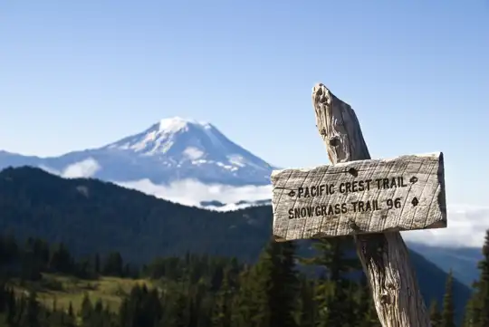
Your heel scrapes granite, trekking pole bites dust, and a gust of dry, high-desert wind slaps sweat into your eyes while Mount Shasta floats on the horizon like a mirage. Pine sap sticks to your fingers. Your pack digs into your hips. Somewhere below, a creek roars just out of reach. This is the Pacific Crest Trail, a 2,600‑plus mile spine of singletrack running from Mexico to Canada along the western edge of the USA. It’s big, brutal, and beautiful in rotating chapters: scorched SoCal desert, Sierra snow, Oregon’s green tunnel, Washington’s jagged drama. The length and logistics are punishing, resupplies can be awkward, and public transport to trailheads is patchy compared with shorter USA classics like the John Muir Trail. But when the light goes pink over a ridge you clawed your way up all day, the scale feels worth the suffering.

Discover everything you want to know in the 📖 the USA Travel Guide.
Best time to go: April - July, September - October
Duration: 120 to 180 days
Distance: 4,265 kilometers
Total ascent: 41,000 meters


Get your USA guide
161 ranked highlights, routes & tips, works offline (586 pages)
Loading the map 🌍
CLICK TO FILTER
cities
towns
villages
landmarks
national parks
hikes
beaches
attractions
festivals
regions
SHOW COUNTRY’S BESTSHOW ALL

✨ Why go?
Ranked #5 hike in the USA
Reasons people choose to hike the here

The Pacific Crest Trail (PCT) is a magnet for backpackers, and for good reason. It’s a grueling yet rewarding trek that spans 2,650 miles from Mexico to Canada, offering a scenery-to-effort ratio that’s hard to beat. You’ll traverse majestic mountains, lush forests, and breathtaking deserts, each step revealing a new vista that makes the sweat worthwhile.

Access is a breeze with public transport options connecting trailheads, allowing you to hop on and off as you please. The low cost of camping and hiking gear makes it accessible for all budgets, and the flexibility in distances means you can tackle it in sections or go all in.

Whether you’re looking for a weekend escape or a multi-month adventure, the PCT fits seamlessly into a longer backpacking route across the USA. The moment you reach … read more 👉
The Pacific Crest Trail (PCT) is a magnet for backpackers, and for good reason. It’s a grueling yet rewarding trek that spans 2,650 miles from Mexico to Canada, offering a scenery-to-effort ratio that’s hard to beat. You’ll traverse majestic mountains, lush forests, and breathtaking deserts, each step revealing a new vista that makes the sweat worthwhile.

Access is a breeze with public transport options connecting trailheads, allowing you to hop on and off as you please. The low cost of camping and hiking gear makes it accessible for all budgets, and the flexibility in distances means you can tackle it in sections or go all in.

Whether you’re looking for a weekend escape or a multi-month adventure, the PCT fits seamlessly into a longer backpacking route across the USA. The moment you reach a summit and take in the view, or crack open that first cold beer at the end of a long day, you’ll understand why this trail calls to so many.
Want to include Pacific Crest Trail in your the USA route?
Create a personalized the USA itinerary that includes Pacific Crest Trail and the places that fit your trip — based on your travel style, budget, and available time. Get your route in seconds.

Generate my trip

💡 HighlightsPlaces and moments you shouldn't skip

  1. Southern California desert to mountain transition — The PCT starts by throwing you into the stark, beautiful Mojave/Colorado Desert: wide washes, ocotillo, and Joshua trees, then climbs out into pine-scented foothills. It’s special because of the extreme contrast in a short distance (and the constant, sobering reminder to plan water carefully). Expect desert wildlife, palm oases, and dramatic elevation gain that makes the rest of the hike feel earned.
  2. High Sierra / John Muir Wilderness (including Forester Pass) — Towering granite, mirror-flat alpine lakes, massive talus fields and snowfields dominate here. Forester Pass is the highest point on the PCT and gives that classic “you’re up in the roof of the world” feeling: knife-edge granite, glacial views and long, strenuous passes. This alpine
read more 👉
  1. Southern California desert to mountain transition — The PCT starts by throwing you into the stark, beautiful Mojave/Colorado Desert: wide washes, ocotillo, and Joshua trees, then climbs out into pine-scented foothills. It’s special because of the extreme contrast in a short distance (and the constant, sobering reminder to plan water carefully). Expect desert wildlife, palm oases, and dramatic elevation gain that makes the rest of the hike feel earned.
  2. High Sierra / John Muir Wilderness (including Forester Pass) — Towering granite, mirror-flat alpine lakes, massive talus fields and snowfields dominate here. Forester Pass is the highest point on the PCT and gives that classic “you’re up in the roof of the world” feeling: knife-edge granite, glacial views and long, strenuous passes. This alpine zone is why many people say the PCT is a pilgrimage—high drama scenery, abundant water (compared to the desert) and some of the trail’s most photogenic nights under the stars. (personal favorite)
  3. Mt. Shasta and Northern California volcanic landscape — Shasta’s perfect volcanic cone looms across the horizon for miles and the surrounding trails cross lava fields, meadows and old-growth forest. It stands out because of the raw volcanic scale—you can do short side trips for huge payoff views, and the sense of wilderness here feels wild and empty compared with the busy parts of the Sierra.
  4. Oregon Cascades: Three Sisters and Mt. Jefferson corridor — A chain of volcanoes, crater lakes, and wildflower-strewn meadows: the Cascades feel younger and greener than the Sierra. The volcanic peaks are dramatic, trail sections cut through lava and pumice, and summer brings insane wildflower displays and alpine lakes that’re perfect for a mid-hike soak or photography stop.
  5. Goat Rocks to the North Cascades (Washington) — Rugged volcanic ridgelines, glaciers in the distance, and wildflower-filled basins define this stretch. Goat Rocks is famous for actual goats (and close-to-the-trail sighting chances), panoramic views of Mount Rainier and Mount Adams, and a sense of remoteness that ramps up as you head north toward the Canadian border. It’s rocky, wild, and ridiculously scenic in a very different—more northern—way than the Sierra.
Spotted a mistake or missing something? Contact us.

🌤️ When to go?Weather, crowds, and seasonal trade-offs


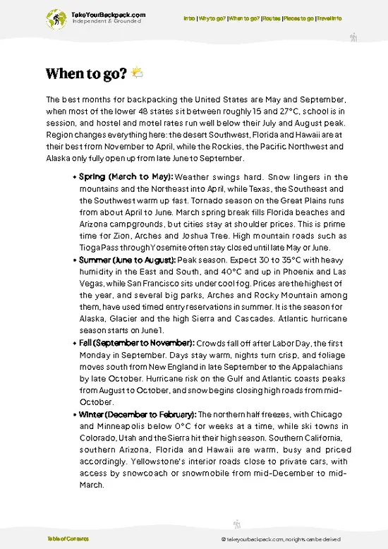
  • Weather: The PCT’s weather swings wildly. Start too early, and you’ll slog through snowdrifts and icy streams. Too late, and the southern sections bake under relentless sun. Late May to early July strikes the balance—snow melts enough to clear the trail, but the heat hasn’t yet turned the desert into a furnace.

  • Temperature: Expect chilly nights around 0°C (32°F) in the northern stretches early on, warming to comfortable 15-25°C (59-77°F) days by mid-summer. Southern California scorches above 30°C (86°F) by late summer, so timing your hike to avoid that is crucial.

  • Daylight Hours: Long summer days mean more hiking time. June and July offer 15+ hours of daylight in the northern sections, letting you push farther without rushing.

  • Crowds: The trail fills up in late spring and early summer.
read more 👉

  • Weather: The PCT’s weather swings wildly. Start too early, and you’ll slog through snowdrifts and icy streams. Too late, and the southern sections bake under relentless sun. Late May to early July strikes the balance—snow melts enough to clear the trail, but the heat hasn’t yet turned the desert into a furnace.

  • Temperature: Expect chilly nights around 0°C (32°F) in the northern stretches early on, warming to comfortable 15-25°C (59-77°F) days by mid-summer. Southern California scorches above 30°C (86°F) by late summer, so timing your hike to avoid that is crucial.

  • Daylight Hours: Long summer days mean more hiking time. June and July offer 15+ hours of daylight in the northern sections, letting you push farther without rushing.

  • Crowds: The trail fills up in late spring and early summer. If you want solitude, start earlier or later, but be ready for tougher conditions or heat.

  • Seasonal Activities: Wildflower blooms peak in late spring, adding bursts of color. Early summer also brings manageable river crossings before snowmelt swells them dangerously.

  • Price Fluctuations: Resupply towns see prices spike in peak season due to demand. Planning your timing can save you cash on food and gear replacements.


Pro-tip: Kick off your hike in late May to catch melting snow, blooming wildflowers, and long days—this window nails the sweet spot between challenge and reward.


source: climatestotravel.comJANJanuary: below average for travelingFEBFebruary: below average for travelingMARMarch: fair for travelingAPRApril: good for travelingMAYMay: excellent for travelingJUNJune: excellent for travelingJULJuly: highly recommended for travelingAUGAugust: fair for travelingSEPSeptember: good for travelingOCTOctober: good for travelingNOVNovember: fair for travelingDECDecember: below average for traveling
United States - the Pacific Crest Trail

✈️ The backpacker research shortcutthe USA Travel Guide

An offline-friendly backpacking guide with optimized travel routes, ranked highlights, transport advice, and the best areas to stay.
example page 0 from our offline Travel Guide for United States
example page 1 from our offline Travel Guide for United States
example page 2 from our offline Travel Guide for United States
example page 3 from our offline Travel Guide for United States
example page 4 from our offline Travel Guide for United States
example page 5 from our offline Travel Guide for United States
example page 6 from our offline Travel Guide for United States
example page 7 from our offline Travel Guide for United States
The digital guide (586 pages) contains:
161 highlights, ranked by travel appeal
Optimized 14, 21 & 30-day travel routes
Cities, national parks, landmarks, beaches
How to get around
Offline-friendly for travel without Wi-Fi
👉 Click to see all 30+ guide features

📅 Plan smarter in minutes, not weeks
Month by month travel advice
Festivals & national holidays
Budget expectations

🗺️ Go to the right places, skip the overrated ones
Honest pros & cons of destinations
Top hikes, parks & viewpoints
Lesser-known places most travelers miss
Clear “worth it vs skip it” guidance

🛏️ Travel smoothly without rookie mistakes
Best areas to stay
Transport systems explained simply
Common scams & safety advice
SIM cards, money & practical tips

🌍 Understand the country, not just visit it
Culture & traditions
Local customs
Festivals worth planning around
Traveler-friendly historical context
Insights that make places more meaningful

📱 Built for real travel conditions
Fully downloadable PDF
Works completely offline
Optimized for phone use
Useful in remote areas & buses
Everything in one place
Save weeks of stressful planning
Get instant access to your full guide. 30‑day money-back guarantee.
+ Add another guide for just US$7.80

By proceeding you agree to our terms.
Sent to your inbox immediately after payment • 100% Secure Checkout
Best Backpacking Travel Advisor 2025 tourism awardBest Backpacking
Travel Advisor
2025
What others say about Take Your Backpack Guides:
⭐⭐⭐⭐⭐
Fantastic, amazing amount of information!
⭐⭐⭐⭐⭐
My goodness this is amazing, it's what I've been looking for hats off too you!
⭐⭐⭐⭐⭐
I think this is absolutely BRILLIANT
⭐⭐⭐⭐
Very complete and informative. It's still missing places, but I gotta to commend you
⭐⭐⭐⭐⭐
This is truly amazing, thank you, can't wait to explore it with my kids!
⭐⭐⭐⭐⭐
Awesome resource, thank you!
⭐⭐⭐⭐⭐
This is amazing! Can't wait to explore the ones I haven't seen
⭐⭐⭐⭐
I love this! Well done, great idea.
⭐⭐⭐⭐⭐
Thanks for taking the time to make this gem!
⭐⭐⭐⭐⭐
This might be the best website I've ever seen.
⭐⭐⭐⭐⭐
Congratulations, and thank you so much for your work; it's incredibly valuable.
⭐⭐⭐⭐
In all seriousness I think you did a great job pointing out the important spots
⭐⭐⭐⭐⭐
10/10 very good
⭐⭐⭐⭐⭐
As someone who's only just starting to visit regularly this is awesome, thank you.
⭐⭐⭐⭐
Thank you very much! I'm going to visit my dad, it's going to be very useful!
⭐⭐⭐⭐⭐
This is really cool! We'll be travelling for the first time and this definitely come in handy.
⭐⭐⭐⭐⭐
You are now our minister of culture, congratulations 👨‍💼
⭐⭐⭐⭐⭐
Just wanted to tell you that this is a pearl! Going to follow your recommendations.
⭐⭐⭐⭐⭐
This is so cool. I'll definitely be using the resource for my travels soon.
⭐⭐⭐⭐⭐
This is very impressive! Good work.
⭐⭐⭐⭐⭐
This is an amazing and informative site. Very well done!

🛏️ Where to stay?Best areas to stay in the USA

If you enjoy meeting fellow travelers, consider choosing hostels with high ratings for atmosphere. On the other hand, if you prefer having your own space, a hotel might be a better option.

🥾 Hike detailsA practical overview of the hike

Total Distance: The Pacific Crest Trail (PCT) stretches about 2,650 miles from the Mexican border in California to the Canadian border in Washington.

Estimated Duration: Most hikers take around 4 to 6 months to complete the trail, depending on their pace and the sections they choose to tackle.

Difficulty Level: This trail is generally considered challenging. It varies from moderate sections to tough climbs and rugged terrain, so it’s not for the faint of heart.

Starting Point: The southern terminus is at the Campo, California border.
  • Public Transport: To get there, you can take a Greyhound
read more 👉
Total Distance: The Pacific Crest Trail (PCT) stretches about 2,650 miles from the Mexican border in California to the Canadian border in Washington.

Estimated Duration: Most hikers take around 4 to 6 months to complete the trail, depending on their pace and the sections they choose to tackle.

Difficulty Level: This trail is generally considered challenging. It varies from moderate sections to tough climbs and rugged terrain, so it’s not for the faint of heart.

Starting Point: The southern terminus is at the Campo, California border.
  • Public Transport: To get there, you can take a Greyhound or Amtrak bus to San Diego, then catch a local bus or rideshare to Campo. It’s about an hour’s drive from downtown San Diego.

Major Landmarks: Along the PCT, you’ll encounter several notable spots:
  • Lake Tahoe: A stunning alpine lake perfect for a rest day.
  • Mount Shasta: An iconic volcano that’s hard to miss.
  • Crater Lake: Known for its deep blue waters, it’s a must-see.
  • North Cascades: A breathtaking range with jagged peaks and lush valleys.

Type of Terrain and Scenery: The PCT offers a mix of terrains:
  • Desert: The southern sections are arid and hot, with sandy trails.
  • Forest: As you move north, you’ll find dense forests and cooler temperatures.
  • Mountain Passes: Expect steep climbs and breathtaking vistas, especially in the Sierra Nevada and Cascades.

Typical Vegetation: The flora changes significantly along the trail:
  • Desert Plants: Cacti and sagebrush dominate the southern stretches.
  • Conifers: Pine, fir, and cedar trees become common as you head north.
  • Wildflowers: In spring and summer, vibrant blooms can be spotted, especially in the Sierra.

Wildlife: You might encounter a variety of animals:
  • Deer: Common in forested areas, they’re often seen grazing.
  • Bears: Black bears are present, especially in the Sierra; proper food storage is crucial.
  • Birds: Look out for eagles, hawks, and many songbirds along the way.

The PCT is a serious commitment, but the diverse landscapes and experiences make it worth every step. Just be prepared, respect the trail, and enjoy the journey!
⚠️ Hiking info can sometimes be outdated or inaccurate. Before you hit the trail, check the latest conditions with locals. If you do spot anything that's off, I'd love to hear from you, so I can update it for fellow travelers.

🛡️ SafetyTraveler Safety Guide

The Pacific Crest Trail (PCT) is a wild ride, but it’s manageable with the right mindset. Weather can shift quickly, especially in the Sierra Nevada. Be ready for sunburn one moment and a sudden downpour the next. Layer up and pack a solid rain jacket.

The terrain varies from smooth stretches to steep climbs that’ll test your legs. Navigation is straightforward, but pay attention to trail markers, especially in foggy conditions. River crossings can be tricky; scout your route and don’t rush.

Wildlife is part of the experience. Spotting a deer or a curious bear can be thrilling, but keep your distance. Make noise to avoid surprises, and store food properly to minimize encounters.

Prepare for altitude changes, especially if you’re not acclimated. Hydration is key. Pace yourself, enjoy the … read more 👉
The Pacific Crest Trail (PCT) is a wild ride, but it’s manageable with the right mindset. Weather can shift quickly, especially in the Sierra Nevada. Be ready for sunburn one moment and a sudden downpour the next. Layer up and pack a solid rain jacket.

The terrain varies from smooth stretches to steep climbs that’ll test your legs. Navigation is straightforward, but pay attention to trail markers, especially in foggy conditions. River crossings can be tricky; scout your route and don’t rush.

Wildlife is part of the experience. Spotting a deer or a curious bear can be thrilling, but keep your distance. Make noise to avoid surprises, and store food properly to minimize encounters.

Prepare for altitude changes, especially if you’re not acclimated. Hydration is key. Pace yourself, enjoy the journey, and savor that first cold beer at the end. The effort pays off in views that’ll stick with you long after the hike.

FAQTraveler FAQ

The Pacific Crest Trail hike typically takes about 4 to 6 months to complete, covering approximately 2,650 miles from Mexico to Canada. Most thru-hikers start in late April to early May to finish before winter. Daily mileage varies but averages around 15 to 20 miles per day.
The Pacific Crest Trail is considered a strenuous hike due to its length, elevation changes, and remote sections. Hikers face diverse terrain including deserts, mountains, and forests, with elevation gains often exceeding 10,000 feet in some segments. Physical fitness and experience with long-distance hiking are essential.
Yes, a permit is required for thru-hiking the Pacific Crest Trail, specifically the PCT Long-distance Permit, which costs around $30 and is issued by the Pacific Crest Trail Association. A guide is not necessary, but many hikers use guidebooks, maps, and GPS apps for navigation.
⚠️ Things can change over time, so always validate details locally before you go.

Other American hikes near Pacific Crest Trail

Explore more nearby:


💡 Not sure where to go next?
Create a personalized itinerary for the USA including Pacific Crest Trail and the places that fit your trip.

Generate my itinerary

👉 Discover all hikes

Or checkout all the USA has to offer (think cities, towns, villages, national parks, hikes, beaches, festivals)
Country photo of the USA

We 💚 feedbackSumming up the experience

The Pacific Crest Trail is a wild symphony of landscapes, where every step reveals a new chapter of the USA’s beauty. You’ll feel the burn in your legs, but that first view of the Sierra Nevada? Worth every ounce of sweat. Just know, the isolation can be intense. You might crave a hot shower and a burger after days in the wild. Embrace the grit; it makes the reward that much sweeter.

✈️ When did I visit the USA?
In January 2023 I visited New York. Many years before, before digital cameras existed, I discovered most of the national parks in the West.

✍️ Help improve this page!
The information on this page is based on my own backpacking experience in the USA, supplemented with up-to-date research and feedback from other travelers. Travel details can change, so if you notice anything outdated or incomplete, feel free to let me know.


🙋‍♂️ Give feedback

👋 Meet the founderWho’s Behind Take Your Backpack?

Johan, backpacker and founder of TakeYourBackpackHi, I’m Johan (Netherlands 🇳🇱), the creator of TakeYourBackpack. Over the past decade, I’ve backpacked through 80+ countries across six continents, gaining extensive experience with independent travel, long-term trips, and overland routes.

This site is built on a combination of firsthand travel experience and carefully curated insights from other backpackers. Many guides are based on places I’ve personally visited, while others bring together tips, observations, and practical advice shared by trusted travelers I’ve met along the way.

The goal is to provide realistic, experience-driven guidance — not generic itineraries — so you can explore destinations with better context, clearer expectations, and more confidence.

Get full USA guide •
Instant download • 161 highlights • Full Offline guide