×

Indonesia🇮🇩 | hikesGunung Semeruactive volcano, ash plain, summit crater | things to do and best time to go

Explore Gunung LawuExplore Gunung Gede Pangrango

Backpacking in Gunung Semeru
🏆 Top pickhike ranked #5
By Johan Kruseman 🇳🇱 | Updated May 30, 2026

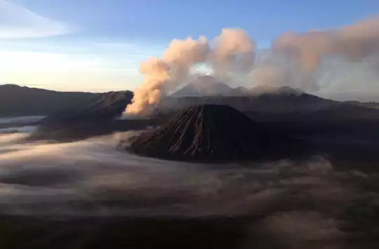
Most people hear “Semeru” and assume it’s just another Bromo-style sunrise lookout. It isn’t. Gunung Semeru, in East Java inside Bromo-Tengger-Semeru National Park, is a full-body commitment: long, dusty, and absolutely not a casual volcano stroll. The hike runs over two days for most people, with a punishing pre-dawn summit push up loose scree that feels like walking on ball bearings. In return, you get raw drama: constant ash puffs from the crater, sea-of-cloud views, and that surreal moment when you’re higher than every other peak in Java. It’s easier to reach than it looks—Malang and Probolinggo have public transport and shared jeeps to Ranu Pani—but it’s still more logistically faffy than Bromo and tougher than nearby Arjuno or Welirang. If Bromo is the postcard, Semeru is the story you actually brag about.

Discover everything you want to know in the 📖 Indonesia Travel Guide.
Best time to go: May - September
Duration: 3 days
Distance: 12 kilometers
Total ascent: 2,400 meters
Loading the map 🌍
CLICK TO FILTER
cities
towns
landmarks
national parks
hikes
beaches
attractions
festivals
regions
SHOW COUNTRY’S BESTSHOW ALL

✨ Why go?
Ranked #5 hike in Indonesia
Why Gunung Semeru should be on your travel list

Gunung Semeru draws backpackers like moths to a flame. The scenery-to-effort ratio is off the charts. You’ll sweat through steep inclines, but the payoff? A panoramic view that stretches across Java, with the sun rising over a sea of clouds. It’s a sight that makes every aching muscle worth it.

Getting there is a breeze. Public transport access is solid, with buses and shared vans whisking you from Malang to the trailhead. You can dive into this adventure without breaking the bank; the low cost of permits and local guides keeps your wallet happy.

What’s more, the hike offers flexible distances. Whether you’re up for a quick day trek or a multi-day challenge, you can tailor your experience. This adaptability makes it a perfect fit in a longer backpacking route through Indonesia.

After conquering … read more 👉
Gunung Semeru draws backpackers like moths to a flame. The scenery-to-effort ratio is off the charts. You’ll sweat through steep inclines, but the payoff? A panoramic view that stretches across Java, with the sun rising over a sea of clouds. It’s a sight that makes every aching muscle worth it.

Getting there is a breeze. Public transport access is solid, with buses and shared vans whisking you from Malang to the trailhead. You can dive into this adventure without breaking the bank; the low cost of permits and local guides keeps your wallet happy.

What’s more, the hike offers flexible distances. Whether you’re up for a quick day trek or a multi-day challenge, you can tailor your experience. This adaptability makes it a perfect fit in a longer backpacking route through Indonesia.

After conquering the summit, nothing beats that first cold beer at a local warung, savoring the moment. Gunung Semeru isn’t just a hike; it’s a rite of passage that rewards grit with breathtaking beauty.
Want to include Gunung Semeru in your Indonesia route?
Create a personalized Indonesia itinerary that includes Gunung Semeru and the places that fit your trip — based on your travel style, budget, and available time. Get your route in seconds.

Generate my trip

💡 HighlightsWhat this place is best known for

  • Ranu Kumbolo — A glassy alpine lake that turns sunrise and the Milky Way into mirror shots. It’s the perfect overnight stop: quiet beaches for tents, easy water access, and that unreal calm after a long day on the trail. (Personal favorite — it’s where the hike stops feeling like a slog and starts feeling like a proper adventure.)
  • Oro-oro Ombo (the highland savannah) — Endless rolling grasslands dotted with the Javan edelweiss and low shrubs; feels more like a windswept steppe than a tropical mountain. The openness, tall grasses, and big skies make for dramatic light at dawn and dusk — and a real contrast to the forested lower sections.
  • Kalimati Camp — The last real basecamp before the summit push, where climbers gather, prep for a pre-dawn start, and trade stories. The barren, wind-whipped
read more 👉
  • Ranu Kumbolo — A glassy alpine lake that turns sunrise and the Milky Way into mirror shots. It’s the perfect overnight stop: quiet beaches for tents, easy water access, and that unreal calm after a long day on the trail. (Personal favorite — it’s where the hike stops feeling like a slog and starts feeling like a proper adventure.)
  • Oro-oro Ombo (the highland savannah) — Endless rolling grasslands dotted with the Javan edelweiss and low shrubs; feels more like a windswept steppe than a tropical mountain. The openness, tall grasses, and big skies make for dramatic light at dawn and dusk — and a real contrast to the forested lower sections.
  • Kalimati Camp — The last real basecamp before the summit push, where climbers gather, prep for a pre-dawn start, and trade stories. The barren, wind-whipped terrain around Kalimati gives you your first full, close-on view of Semeru’s cone and the scale of what’s ahead.
  • Arcopodo Viewpoint — A photogenic natural rock arch that frames Mount Semeru across a sea of clouds; sunrise photos from here are iconic. It’s a short scramble off the main track and rewards you with cinematic perspectives you won’t get anywhere else on the island.
  • Mahameru Summit & Crater Rim — The payoff: a dawn panorama over the Tengger caldera, with Mount Bromo and the ocean of clouds below. It’s also an active volcano, so the rim’s steaming crater and occasional rumble make the moment visceral — but respect park rules and closures, because conditions change fast and it can be dangerous.
Spotted a mistake or missing something? Contact us.
Things to do around Gunung Semeru

Ratings based on Tripadvisor reviews. When you book through this link, you support our work at no extra cost to you.

🌤️ When to go?Seasonal considerations and timing


  • Weather: The dry season from May to September is your best shot. Trails stay firm, not slick with mud, and the skies clear up for those epic summit views. The wet season, October to April, drags you through slippery slopes and persistent rain that can kill your vibe and your grip.

  • Temperature: Expect daytime temps around 15-25°C (59-77°F) at base camp, dropping sharply near the summit to near freezing, especially at night. Dress in layers—cold bites hard above 3,600 meters.

  • Daylight Hours: Roughly 11-12 hours year-round, but the dry season’s clearer skies mean you’ll get more reliable light for early starts and late finishes without fumbling in the dark.

  • Crowds: Peak dry months bring more trekkers, especially July and August. If you want solitude, aim for May or September—still dry,
read more 👉

  • Weather: The dry season from May to September is your best shot. Trails stay firm, not slick with mud, and the skies clear up for those epic summit views. The wet season, October to April, drags you through slippery slopes and persistent rain that can kill your vibe and your grip.

  • Temperature: Expect daytime temps around 15-25°C (59-77°F) at base camp, dropping sharply near the summit to near freezing, especially at night. Dress in layers—cold bites hard above 3,600 meters.

  • Daylight Hours: Roughly 11-12 hours year-round, but the dry season’s clearer skies mean you’ll get more reliable light for early starts and late finishes without fumbling in the dark.

  • Crowds: Peak dry months bring more trekkers, especially July and August. If you want solitude, aim for May or September—still dry, but fewer people carving up the trail.

  • Seasonal Activities: The dry season aligns with local festivals and mountain rituals, adding cultural layers to your climb. The wet season shuts down many services, so fewer chances to tap into local life.

  • Price Fluctuations: Dry season means higher prices for guides, permits, and lodging. Off-season drops costs but expect fewer amenities and a tougher trail.


Pro-tip: Start your trek early in the dry season to dodge crowds and catch the mountain’s raw power before the tourist rush dulls the experience.


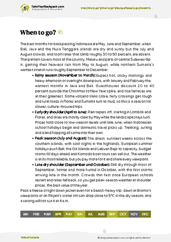
source: climatestotravel.comJANJanuary: below average for travelingFEBFebruary: below average for travelingMARMarch: below average for travelingAPRApril: fair for travelingMAYMay: highly recommended for travelingJUNJune: excellent for travelingJULJuly: excellent for travelingAUGAugust: excellent for travelingSEPSeptember: highly recommended for travelingOCTOctober: fair for travelingNOVNovember: below average for travelingDECDecember: below average for traveling
when-to-go

✈️ The backpacker research shortcutIndonesia Travel Guide

An offline-friendly backpacking guide with optimized travel routes, ranked highlights, transport advice, and the best areas to stay.
example page 0 from our offline Travel Guide for Indonesia
example page 1 from our offline Travel Guide for Indonesia
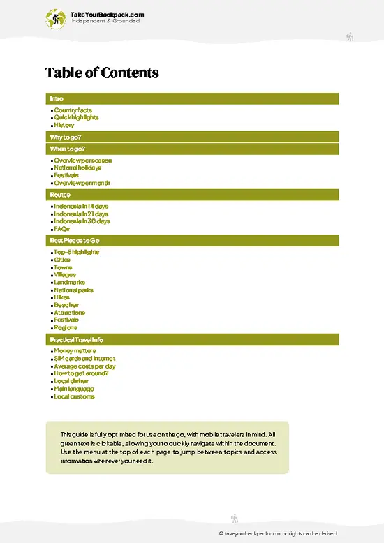
example page 2 from our offline Travel Guide for Indonesia
example page 3 from our offline Travel Guide for Indonesia
example page 4 from our offline Travel Guide for Indonesia
example page 5 from our offline Travel Guide for Indonesia
example page 6 from our offline Travel Guide for Indonesia
example page 7 from our offline Travel Guide for Indonesia
The digital guide (550 pages) contains:
155 highlights, ranked by travel appeal
Optimized 14, 21 & 30-day travel routes
Cities, national parks, landmarks, beaches
How to get around
Offline-friendly for travel without Wi-Fi
👉 Click to see all 30+ guide features

📅 Plan smarter in minutes, not weeks
Month by month travel advice
Festivals & national holidays
Budget expectations

🗺️ Go to the right places, skip the overrated ones
Honest pros & cons of destinations
Top hikes, parks & viewpoints
Lesser-known places most travelers miss
Clear “worth it vs skip it” guidance

🛏️ Travel smoothly without rookie mistakes
Best areas to stay
Transport systems explained simply
Common scams & safety advice
SIM cards, money & practical tips

🌍 Understand the country, not just visit it
Culture & traditions
52 Essential phrases & customs
Festivals worth planning around
Traveler-friendly historical context
Insights that make places more meaningful

📱 Built for real travel conditions
Fully downloadable PDF
Works completely offline
Optimized for phone use
Useful in remote areas & buses
Everything in one place
Save weeks of stressful planning
Get instant access to your full guide. 30‑day money-back guarantee.


By proceeding you agree to our terms.
Sent to your inbox immediately after payment • 100% Secure Checkout
Best Backpacking Travel Advisor 2025 tourism awardBest Backpacking
Travel Advisor
2025
What others say about Take Your Backpack Guides:
⭐⭐⭐⭐⭐
Fantastic, amazing amount of information!
⭐⭐⭐⭐⭐
My goodness this is amazing, it's what I've been looking for hats off too you!
⭐⭐⭐⭐⭐
I think this is absolutely BRILLIANT
⭐⭐⭐⭐
Very complete and informative. It's still missing places, but I gotta to commend you
⭐⭐⭐⭐⭐
This is truly amazing, thank you, can't wait to explore it with my kids!
⭐⭐⭐⭐⭐
Awesome resource, thank you!
⭐⭐⭐⭐⭐
This is amazing! Can't wait to explore the ones I haven't seen
⭐⭐⭐⭐
I love this! Well done, great idea.
⭐⭐⭐⭐⭐
Thanks for taking the time to make this gem!
⭐⭐⭐⭐⭐
This might be the best website I've ever seen.
⭐⭐⭐⭐⭐
Congratulations, and thank you so much for your work; it's incredibly valuable.
⭐⭐⭐⭐
In all seriousness I think you did a great job pointing out the important spots
⭐⭐⭐⭐⭐
10/10 very good
⭐⭐⭐⭐⭐
As someone who's only just starting to visit regularly this is awesome, thank you.
⭐⭐⭐⭐
Thank you very much! I'm going to visit my dad, it's going to be very useful!
⭐⭐⭐⭐⭐
This is really cool! We'll be travelling for the first time and this definitely come in handy.
⭐⭐⭐⭐⭐
You are now our minister of culture, congratulations 👨‍💼
⭐⭐⭐⭐⭐
Just wanted to tell you that this is a pearl! Going to follow your recommendations.
⭐⭐⭐⭐⭐
This is so cool. I'll definitely be using the resource for my travels soon.
⭐⭐⭐⭐⭐
This is very impressive! Good work.
⭐⭐⭐⭐⭐
This is an amazing and informative site. Very well done!

🛏️ Where to stay?How to pick the right area

If you enjoy meeting fellow travelers, consider choosing hostels with high ratings for atmosphere. On the other hand, if you prefer having your own space, a hotel might be a better option.

🥾 Hike detailsKey facts about the Gunung Semeru hike

Total Distance: The hike to the summit of Gunung Semeru is approximately 12 kilometers (7.5 miles) one way, making it about 24 kilometers (15 miles) round trip.

Estimated Duration: Expect to spend around 10 to 14 hours for the entire trek, depending on your pace and how often you stop to take in the views.

Difficulty Level: This trail is generally rated as difficult. It involves steep ascents, rocky paths, and some sections where you’ll need to scramble a bit.

Starting Point: The trek begins at Ranu Pani, which is accessible by public transport.
  • From Malang: Take a minibus or a bemo to Tumpang,
read more 👉
Total Distance: The hike to the summit of Gunung Semeru is approximately 12 kilometers (7.5 miles) one way, making it about 24 kilometers (15 miles) round trip.

Estimated Duration: Expect to spend around 10 to 14 hours for the entire trek, depending on your pace and how often you stop to take in the views.

Difficulty Level: This trail is generally rated as difficult. It involves steep ascents, rocky paths, and some sections where you’ll need to scramble a bit.

Starting Point: The trek begins at Ranu Pani, which is accessible by public transport.
  • From Malang: Take a minibus or a bemo to Tumpang, then switch to a 4WD vehicle or shared transport to Ranu Pani. The whole journey can take around 2-3 hours.
  • From Probolinggo: You can take a bus to Lumajang, then catch a ride to Ranu Pani, though this option may take longer and involve more transfers.

Major Landmarks Along the Route:
  • Ranu Pani: A beautiful lake that serves as a great starting point and a perfect spot to camp before heading up.
  • Ranu Kumbolo: A stunning lake about halfway up, ideal for resting and soaking in the scenery.
  • Kalimati: The last campsite before the summit, where many hikers rest before the final push.
  • Summit of Semeru: The highest peak in Java at 3,676 meters (12,060 feet), offering breathtaking panoramic views.

Type of Terrain and Scenery: The trail features a mix of dirt paths, rocky sections, and some steep inclines. You’ll traverse through lush forests, open grasslands, and volcanic landscapes. The views change dramatically as you ascend, from dense greenery to stark, rugged terrain near the summit.

Typical Vegetation and Wildlife:
  • Vegetation: Expect to see a variety of flora, including pine trees, edelweiss flowers, and various shrubs as you climb. The lower sections are more forested, while higher up, the vegetation becomes sparser.
  • Wildlife: Keep an eye out for birds, monkeys, and possibly even the elusive Javan leopard, though they’re rare. Most wildlife tends to be more active at lower elevations.

This trail is a fantastic adventure for those looking to experience Indonesia’s natural beauty, but be sure to prepare well, as it can be a challenging trek!
⚠️ Hiking info can sometimes be outdated or inaccurate. Before you hit the trail, check the latest conditions with locals. If you do spot anything that's off, I'd love to hear from you, so I can update it for fellow travelers.

🛡️ SafetyScams, Hazards, and Annoyances

Gunung Semeru is a stunning trek, but it demands respect. Weather can shift in an instant; sunny mornings can morph into rain-soaked afternoons. Dress in layers and pack a reliable rain jacket. The trail is steep and rocky, with sections that require careful footing. Navigation is straightforward, but don’t let your guard down—stay alert to the terrain.

Altitude can hit hard, especially if you’re not acclimatized. Take your time; slow and steady wins this race. River crossings are manageable but can swell after rain, so be prepared to get your feet wet.

Wildlife encounters are rare but possible. If you spot a monkey, keep your snacks close—these little thieves are quick! Respect their space and don’t feed them.

Most importantly, embrace the journey. The grind up is worth it when you reach … read more 👉
Gunung Semeru is a stunning trek, but it demands respect. Weather can shift in an instant; sunny mornings can morph into rain-soaked afternoons. Dress in layers and pack a reliable rain jacket. The trail is steep and rocky, with sections that require careful footing. Navigation is straightforward, but don’t let your guard down—stay alert to the terrain.

Altitude can hit hard, especially if you’re not acclimatized. Take your time; slow and steady wins this race. River crossings are manageable but can swell after rain, so be prepared to get your feet wet.

Wildlife encounters are rare but possible. If you spot a monkey, keep your snacks close—these little thieves are quick! Respect their space and don’t feed them.

Most importantly, embrace the journey. The grind up is worth it when you reach the summit and soak in that breathtaking view. Afterward, nothing tastes better than a cold drink at base camp.

Other Indonesian hikes near Gunung Semeru

Explore more nearby:

  • Mount Bromo—sea of sand, smoking caldera, Tengger culture| 19 km away
  • Ijen Crater—sulfur mine, turquoise lake, blue flames| 146 km away
  • Alas Purwo—coastal forest, wild banteng, remote savanna| 180 km away

💡 Not sure where to go next?
Create a personalized itinerary for Indonesia including Gunung Semeru and the places that fit your trip.

Generate my itinerary

👉 Discover all hikes

Or checkout all Indonesia has to offer (think cities, towns, villages, national parks, hikes, beaches, festivals)
Country photo of Indonesia

We 💚 feedbackIs it worth it?

Gunung Semeru is a beast of a hike, but the reward? Standing at the summit, watching the sunrise paint the sky in fiery hues—it’s a moment that’ll stick with you. Just know, the trail is relentless. Expect steep climbs and unpredictable weather. It’s not for the faint-hearted, but if you’re ready to sweat, the view is worth every drop. Embrace the challenge; it’s all part of the adventure.

✈️ When did I visit Indonesia?
As part of my 1.5 year travel around the world trip, I visited Indonesia twice (and it was worth it. First in September 2015 and a bit later again in January and February 2016.

✍️ Help improve this page!
The information on this page is based on my own backpacking experience in Indonesia, supplemented with up-to-date research and feedback from other travelers. Travel details can change, so if you notice anything outdated or incomplete, feel free to let me know.


🙋‍♂️ Give feedback

👋 Meet the founderWho’s Behind Take Your Backpack?

Johan, backpacker and founder of TakeYourBackpackHi, I’m Johan (Netherlands 🇳🇱), the creator of TakeYourBackpack. Over the past decade, I’ve backpacked through 80+ countries across six continents, gaining extensive experience with independent travel, long-term trips, and overland routes.

This site is built on a combination of firsthand travel experience and carefully curated insights from other backpackers. Many guides are based on places I’ve personally visited, while others bring together tips, observations, and practical advice shared by trusted travelers I’ve met along the way.

The goal is to provide realistic, experience-driven guidance — not generic itineraries — so you can explore destinations with better context, clearer expectations, and more confidence.

Get full Indonesia guide •
Instant download • 155 highlights • Full Offline guide